
Friedrich Wolfgang Beckey, known as Fred Beckey, was an American rock climber, mountaineer and book author, who in seven decades of climbing achieved hundreds of first ascents of some of the tallest peaks and most important routes throughout Alaska, the Canadian Rockies and the Pacific Northwest. Among the Fifty Classic Climbs of North America, seven were established by Beckey, often climbing with some of the best known climbers of each generation.

Mount Edith Cavell is a mountain in the Athabasca River and Astoria River valleys of Jasper National Park, and the most prominent peak entirely within Alberta.

Shiprock is a monadnock rising nearly 1,583 feet (482.5 m) above the high-desert plain of the Navajo Nation in San Juan County, New Mexico, United States. Its peak elevation is 7,177 feet (2,187.5 m) above sea level. It is about 10.75 miles (17.30 km) southwest of the town of Shiprock, which is named for the peak.
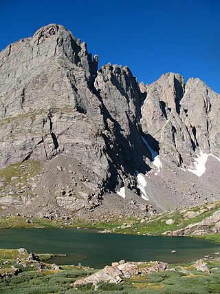
Crestone Needle is a high mountain summit of the Crestones in the Sangre de Cristo Range of the Rocky Mountains of North America. The 14,203-foot (4,329 m) fourteener is located 6.9 miles (11.1 km) east-southeast of the Town of Crestone in Saguache County, Colorado, United States. The Crestones are a cluster of high summits in the Sangre de Cristo Range, comprising Crestone Peak, Crestone Needle, Kit Carson Peak, Challenger Point, Humboldt Peak, and Columbia Point. They are usually accessed from common trailheads.
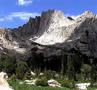
Middle Triple Peak is the second highest peak in the Kichatna Mountains, a subrange of the Alaska Range in Alaska, United States. It is a striking rock tower, with immense, sheer walls on the east and west sides.

Layton Kor was an American rock climber active in the 1960s, whose first ascents and drive for climbing are well known in the climbing world. His routes included many climbs in Eldorado Canyon, near Boulder, Colorado, The Diamond on Longs Peak, towers in the desert southwest, and Yosemite National Park, among other locations. Notable among his first ascents is the Kor-Ingalls Route on Castleton Tower and The Finger of Fate Route up the Fisher Towers' Titan; both routes are recognized in the historic climbing text Fifty Classic Climbs of North America.

Fifty Classic Climbs of North America is a climbing guidebook and history written by Steve Roper and Allen Steck. It is considered a classic piece of climbing literature, known to many climbers as simply "The Book", and has served as an inspiration for more recent climbing books, such as Mark Kroese's Fifty Favorite Climbs. Though much of the book's contents are now out of date, it is still recognized as a definitive text which goes beyond the traditional guidebook.

The Durrance Route is a climbing route on Devils Tower in Wyoming, United States. First pioneered by Jack Durrance and Harrison Butterworth in September 1938, it was the second free ascent of Devils Tower, following the first ascent led by Fritz Wiessner in 1937. The Wiessner Route lies a few hundred feet to the right of the Durrance Route and has a comparable difficulty. Today the Durrance Route is the most popular route on Devils Tower. It is considered a more interesting and enjoyable route than the Wiessner Route, due to more variable terrain and better belay stances. The route is recognized in the historic climbing text, Fifty Classic Climbs of North America, and other guide books.

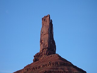
Castleton Tower is a 400-foot (120 m) Wingate Sandstone tower standing on a 1,000 foot Moenkopi-Chinle cone above the northeastern border of Castle Valley, Utah. The tower is world-renowned as a subject for photography and for its classic rock climbing routes, the most famous of which is the Kor-Ingalls Route featured in Fifty Classic Climbs of North America. It can be accessed by a trail that begins south of the tower at a primitive camp ground.
The Kor-Ingalls Route is a traditional rock climbing route located on Castleton Tower. Castleton Tower sits in Castle Valley North-East of Moab, Utah. The Route is recognized in the historic climbing text Fifty Classic Climbs of North America and considered a classic around the world.

Fisher Towers are a series of towers made of Cutler sandstone capped with Moenkopi sandstone and caked with a stucco of red mud located near Moab, Utah. The Towers are named for a miner who lived near them in the 1880s. The Towers are world-renowned as a subject for photography and for its classic rock climbing routes.

The Finger of Fate is an aid rock climbing route located in Moab, Utah, on the Titan, the tallest of the Fisher Towers. It was first climbed in 1962. The route saw its first clean ascent in 1996 by Stevie Haston and Laurence Gauoult. The route is recognized in the historic climbing text Fifty Classic Climbs of North America and considered a classic around the world.

The East Face of Mount Whitney is a technical alpine rock climbing route and is featured in Fifty Classic Climbs of North America. Mount Whitney is the highest peak in the contiguous United States.
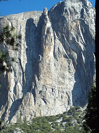
Lost Arrow Spire is a detached pillar in Yosemite National Park, in Yosemite Valley, California, located immediately adjacent to Upper Yosemite Falls. The structure includes the Lost Arrow Spire Chimney route which is recognized in the historic climbing text Fifty Classic Climbs of North America. The spire is the location for a dramatic Tyrolean traverse, which has since become an iconic slackline.
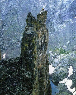
Petit Grepon is a semi-detached spire in Colorado's Rocky Mountain National Park. It is one of the "Cathedral Spires" which also includes: Sharkstooth, The Saber, and The Foil. The South Face route of Petit Grepon is described in the historic climbing text Fifty Classic Climbs of North America and considered a classic around the world.
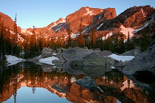
Hallett Peak is a mountain summit in the northern Front Range of the Rocky Mountains of North America. The 12,720-foot (3,877 m) peak is located in the Rocky Mountain National Park Wilderness, 10.1 miles (16.2 km) southwest by west of the Town of Estes Park, Colorado, United States, on the Continental Divide between Grand and Larimer counties.

The Middle Cathedral Rock is a prominent rock face on the south side of Yosemite Valley, California. El Capitan lies due north of Middle Cathedral. Middle Cathedral's East Buttress Route is recognized in the historic climbing text Fifty Classic Climbs of North America.

The North Face of Fairview Dome also known as the Regular Route of Fairview Dome is a technical rock climbing route in Tuolumne Meadows of Yosemite National Park. It is featured in Fifty Classic Climbs of North America.

Thomas "Tom" M. Frost was an American rock climber known for big wall climbing first ascents in Yosemite Valley. He was also a photographer and climbing equipment manufacturer. Frost was born in Hollywood, California, and died in Oakdale, California.
Wolfs Head is a mountain located in the southern Wind River Range in the U.S. state of Wyoming. Wolfs Head is on the northwest side of the Cirque of the Towers, a popular climbing area. The peak is just north of Overhanging Tower and connected to Pingora Peak by a narrow arête. The East Ridge route on the Wolf's Head is recognized in the historic climbing text Fifty Classic Climbs of North America and considered a classic climb. Wolfs Head is situated on the Continental Divide.


