| Titiwangsa Forest Complex | |
|---|---|
| Location | Titiwangsa Mountains, Peninsular Malaysia |
The Titiwangsa Forest Complex runs along the Titiwangsa Mountains and forms part of the Central Forest Spine of Peninsular Malaysia.


| Titiwangsa Forest Complex | |
|---|---|
| Location | Titiwangsa Mountains, Peninsular Malaysia |
The Titiwangsa Forest Complex runs along the Titiwangsa Mountains and forms part of the Central Forest Spine of Peninsular Malaysia.
The Titiwangsa Forest Complex comprises the following patches which are divided by roads running from East to West across the range:
Lebuhraya Timur–Barat (Malaysia Federal Route 4)
Lebuhraya Timur–Barat Kedua (Malaysia Federal Route 185)
Jalan Kuala Kubu Bharu–Raub (Malaysia Federal Route 55)
Kuala Lumpur–Karak Expressway (Malaysia Federal Route 2, 68, E8)


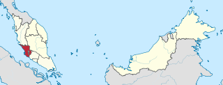
Selangor, also known by the Arabic honorific Darul Ehsan, or "Abode of Sincerity", is one of the 13 states of Malaysia. It is on the west coast of Peninsular Malaysia and is bordered by Perak to the north, Pahang to the east, Negeri Sembilan to the south, and the Strait of Malacca to the west. Selangor surrounds the federal territories of Kuala Lumpur and Putrajaya, both of which were previously part of it. Selangor has diverse tropical rainforests and an equatorial climate. The state's mountain ranges belong to the Titiwangsa Mountains, which is part of the Tenasserim Hills that covers southern Myanmar, southern Thailand and Peninsular Malaysia, with Mount Semangkok as the highest point in the state.

Negeri Sembilan, historically spelled as Negri Sembilan, is a state in Malaysia which lies on the western coast of Peninsular Malaysia. It borders Selangor on the north, Pahang in the east, and Malacca and Johor to the south.
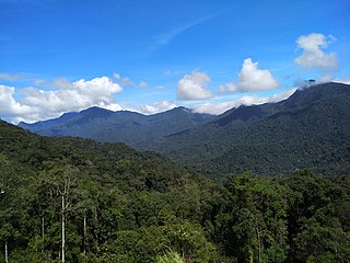
The Titiwangsa Mountains, also known as Banjaran Besar by locals, is the chain of mountains that forms the backbone of the Malay Peninsula. The northern section of the range is in southern Thailand, where it is known as the Sankalakhiri Range.

The Pahang River mainly flows through the state of Pahang, Malaysia. Its drainage basin covers its Pahang as well as the neighbouring state of Negeri Sembilan.
The East Coast Expressway is an interstate controlled-access highway running parallel to the northeastern coast of Peninsular Malaysia. The currently operational 433-kilometre (269-mile) segment of the expressway runs through Karak, Pahang and Kuala Nerus, Terengganu.
The Federal Route 2 is a major east–west oriented federal highway in Malaysia. The 276.9 kilometres (172 mi) road connects Port Klang in Selangor to Kuantan Port in Pahang. The Federal Route 2 became the backbone of the road system linking the east and west coasts of Peninsula Malaysia before being surpassed by the East Coast Expressway E8.
Federal Route 55 or Jalan Kuala Kubu Bharu–Teranum–Raub is a 62-km federal road connecting the states of Selangor and Pahang in Malaysia. It is the first federal road ever constructed in Pahang. The road connects Kuala Kubu Bharu, Selangor to Teranum near Raub in Pahang where it meets Federal Route 218. It is the main access route to Fraser's Hill.
Jalan Seremban-Kuala Pilah or Federal Route 51 is the main federal road in Negeri Sembilan, Malaysia, connecting Seremban to Kuala Pilah. It is a relatively busy road in Negeri Sembilan.
Federal Route 68, also known as Jalan Gombak or Jalan Karak Lama, is a federal road in Malaysia that links the city of Kuala Lumpur to Bentong, Pahang. Before Kuala Lumpur–Karak Expressway E8/FT2 was built, the road was used to be a part of Kuala Lumpur–Kuantan Road FT2; however, due to its sharp corners, narrow roadway and lack of safety features, a replacement highway known as the Kuala Lumpur–Karak Highway FT2 was built, causing the former Kuala Lumpur–Bentong section to be re-gazetted as the Federal Route 68.

Federal Route 9 or Karak–Tampin Highway is a federal road in Pahang and Negeri Sembilan, Malaysia. It connects Karak, Pahang in the north with Tampin, Negeri Sembilan in the south, running along the eastern edge of the Titiwangsa Mountains.
Second East–West Highway, also known as Simpang Pulai–Kuala Berang Highway, Federal Route 185 and Federal Route 36, is a highway in Peninsular Malaysia which connects Simpang Pulai in Perak to Kuala Jeneris in Terengganu. It overlaps with Federal Route 8 Federal Route 8 between Gua Musang and Sungai Relau. It is notorious for its many sharp corners which increase the risk of road accidents.
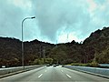
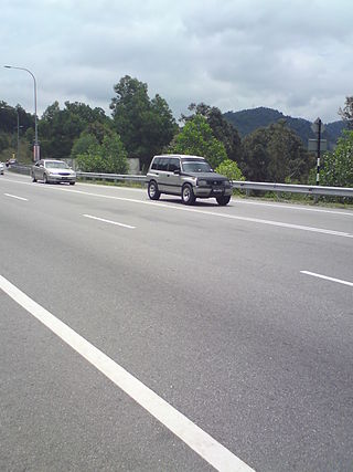
The Kuala Lumpur–Karak Expressway East Coast Expressway is a 60-kilometre (37 mi) interstate controlled-access highway in Peninsular Malaysia. It runs between the town of Gombak in Selangor to the southwest and Karak in Pahang to the northeast. The expressway was previously a single-carriageway trunk road forming part of federal route 2; this designation has been kept after the upgrade in 1997. It shares its designation with the East Coast Expressway proper that succeeds it.

Peninsular Malaysia, historically known as Malaya, also known as West Malaysia or the "Malaysian Peninsula", is the western part of Malaysia that comprises the southern part of the Malay Peninsula on Mainland Southeast Asia and the nearby islands. Its area totals approximately 132,490 km2 (51,150 sq mi), which is nearly 40% of the total area of the country; the other 60% is in East Malaysia on the island of Borneo.

Greater Kuala Lumpur is the geographical term that determines the boundaries of metropolitan Kuala Lumpur in Malaysia. Though similar to the term "Klang Valley", there remains a variation between the two. Ranked as the 30th-largest in Asia, it covers a total land size of 13,565.61 km2.

Kuala Pilah, or simply Pilah, is a town in Kuala Pilah District, Negeri Sembilan, Malaysia. It is 36 km from the state capital Seremban and 101 km from Kuala Lumpur.
Liga Malaysia was an amateur football league in Malaysia that operated from 1982 until 1988. The league was managed by the Football Association of Malaysia. The Malaysian League was established in 1982 after the introduction of a league trophy for the winner of the league stage qualification round for the Malaysia Cup, with the format first introduced in 1979 where the top eight teams qualified from the league to compete in the knockout stages of the Malaysia Cup.

Bentong District is a district located in western Pahang, Malaysia. Bentong covers an area of 1,831 km2 and includes the hill resorts of Genting Highlands and Bukit Tinggi. It is located 80 km northeast of Kuala Lumpur, just across the main range, Titiwangsa Mountains. Bentong Town is the seat of the district. The district of Bentong is also further divided into 3 mukims (sub-districts), they are Bentong, Sabai and Pelabgai. The original Main Street going into Bentong Town has been modified to a dual carriageway. It is bordered by Selangor on the west and Negeri Sembilan on the south.

The Minangkabau Malaysians are citizens of the Malaysia whose ancestral roots are from Minangkabau of central Sumatra. This includes people born in the Malaysia who are of Minangkabau origin as well as Minangkabau who have migrated to Malaysia. Today, Minangkabau comprise about 989,000 people in Malaysia, and Malaysian law considers most of them to be Malays. They are majority in urban areas, which has traditionally had the highest education and a strong entrepreneurial spirit. The history of the Minangkabau migration to Malay peninsula has been recorded to have lasted a very long time. When the means of transportation were still using the ships by down the rivers and crossing the strait, many Minang people migrated to various regions such as Negeri Sembilan, Malacca, Penang, Kedah, Perak, and Pahang. Some scholars noted that the arrival of the Minangkabau to the Malay Peninsula occurred in the 12th century. This ethnic group moved in to peninsula at the height of the Sultanate of Malacca, and maintains the Adat Perpatih of matrilineal kinships system in Negeri Sembilan and north Malacca.
Mount Besar Hantu is a mountain in Kenaboi, Jelebu District, Negeri Sembilan, Malaysia, located near the border with Pahang. It is the tallest peak in Negeri Sembilan as well in southern Peninsular Malaysia, at the height of 1,462 m (4,797 ft).

Mount Telapak Buruk is a mountain situated on the boundary between Jelebu and Seremban Districts in the Malaysian state of Negeri Sembilan. At an altitude of 1,193 metres above sea level, it is the third tallest mountain in Negeri Sembilan and the tallest mountain fully within the state.