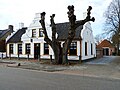
Tolbert, Netherlands

Last updated
Tolbert
Town
Tolbert - smederij.jpg
Former smithy in Tolbert
2010-NL-P01-Groningen-positiekaart-gemnamen.jpg
Red pog.svg
Tolbert
Location in province of Groningen in the Netherlands
Netherlands location map.svg
Red pog.svg
Tolbert
Tolbert (Netherlands)
Coordinates: 53°10′13″N6°21′45″E / 53.1703°N 6.3624°E / 53.1703; 6.3624
CountryFlag of the Netherlands.svg Netherlands
ProvinceFlag of Groningen.svg Groningen
Municipality Westerkwartier vlag.svg Westerkwartier
Area
[1]
  Total
12.74 km2 (4.92 sq mi)
Elevation
[2]
4 m (13 ft)
Population
 (2021) [1]
  Total
4,475
  Density350/km2 (910/sq mi)
Time zone UTC+1 (CET)
  Summer (DST) UTC+2 (CEST)
Postal code
9356
Dialing code 0594

Tolbert is a town in the Dutch province of Groningen. It is part of the municipality of Westerkwartier and forms a single urban area with Leek.

Contents

History

Tolbert is located in the Vredewold  [ nl ] region. The area was settled during the 10th and 11th century. [3] It was first mentioned in 1479 as Oldebert. The name is a contraction of het (the definite article) ol(de) (old) and bert (borough, village), and literally means "the old village". [4] The church is from the 17th century, but contains 13th century parts. [5] The parish dates from the 14th century. In 1794, Tolbert bought a seat in the States of Groningen from Aduard, [6] and in 1795 was the seat of a municipality with Midwolde, Lettelbert and Oostwold. In 1795, it was home to 476 people. [7] By 1817, it was part of the municipality of Leek. [8]

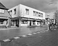
Tolbert was mainly an agricultural community, however the industrialisation of nearby Leek attracted people to the village. [3] In 1907, there was a malaria outbreak in Tolbert. [9] After World War II, Tolbert and Leek became a single urban area, however it remained a separate entity. In 2019, it became part of the municipality of Westerkwartier. [3]

Sports

In 1950, a street circuit for motorcycle racing was set-up in the village. In 1956, it was considered too dangerous and was no longer permitted. In 1970, permission was granted outside the build-up area. [3] In 1984, Jack Middelburg was killed during a race. [10] In 2008, the races ended, because the organisation could not finance the required safety investments. [11]

References

  1. 1 2 "Kerncijfers wijken en buurten 2021". Central Bureau of Statistics. Retrieved 7 March 2022.
  2. "Postcodetool for 9356AA". Actueel Hoogtebestand Nederland (in Dutch). Het Waterschapshuis. Retrieved 7 March 2022.
  3. 1 2 3 4 "Tolbert". Plaatsengids (in Dutch). Retrieved 7 March 2022.
  4. "Tolbert". Etymologiebank (in Dutch). Retrieved 7 March 2022.
  5. Redmer Alma (1998). Leek (in Dutch). Zwolle: Waanders Uitgevers. p. 153. ISBN   90 400 9258 3 . Retrieved 7 March 2022.
  6. P.J. Blok and S. Muller (1923). Geschiedkundige atlas van Nederland part II (in Dutch). The Hague: Nijhoff. p. 24. Retrieved 7 March 2022.
  7. Verdeling van de provincie van Stad en Lande (in Dutch). Groningen: Jan Oomkens. 1796. p. 36. Retrieved 7 March 2022.
  8. "Benoemingen". Groninger courant (in Dutch). 3 January 1817. Retrieved 7 March 2022. Probably reorganised during the occupation by Napoleon
  9. Heinrich Joseph Maria Schade (1909). Malaria in Noord-Nederland (Thesis) (in Dutch). Groningen: De Waal. p. 4. Retrieved 7 March 2022.
  10. "Middelburg bezwijkt aan verwondingen" (in Dutch). 4 April 1984. Retrieved 7 March 2022.
  11. Jaap van Brummelen (15 April 2008). "Nooit meer CC races op circuit Tolbert". Dagblad van het Noorden (in Dutch). Retrieved 7 March 2022.

Commons-logo.svg Media related to Tolbert at Wikimedia Commons