Uden is a town and former municipality in the province of North Brabant, in the Netherlands. Since 2022 it has been part of the new municipality of Maashorst.

Zoetermeer is a city in the Western Netherlands, in the province of South Holland. The municipality covers an area of 37.05 km2 (14.31 sq mi) of which 2.60 km2 (1.00 sq mi) is water. A small village until the late 1960s, it had 6,392 inhabitants in 1950. By 2023 this had grown to 126.998, making it the fourth largest population centre in the province of South Holland, after Rotterdam, The Hague and Leiden. While now a city in its own right, Zoetermeer started out as a suburb of The Hague and is still a part of the Greater The Hague urban area.
Zuid Haffel is a polder and hamlet in the northwest of the Netherlands. It is located on the island of Texel, North Holland. Texel is also the municipality of the place.
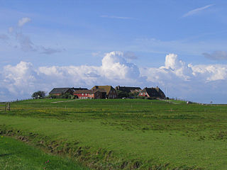
A terp, also known as a wierde, woerd, warf, warft, werf, werve, wurt or værft, is an artificial dwelling mound found on the North European Plain that has been created to provide safe ground during storm surges, high tides and sea or river flooding. The various terms used reflect the regional dialects of the North European region.

Achterbos is a hamlet in the Dutch province of Utrecht. It is located in the municipality of De Ronde Venen, directly north of Vinkeveen.
Meer [mɪːr] is a hamlet in the Dutch province of Overijssel. It is located in the municipality of Twenterand, about 2 km west of the town of Den Ham.
Driehuizen is a hamlet in the Dutch province of North Holland. It is located on the island of Texel, about 2 km southwest of the town of Den Burg. The name related to three fames were present at the site during the 16th century.

Heikant is a hamlet in the Dutch province of North Brabant. It is located in the municipality of Alphen-Chaam, about 2 km northeast of Chaam.

Brand is a hamlet in the municipality of Beekdaelen in the province of Limburg, the Netherlands. It is one of the so-called Bovengehuchten, or Upper Hamlets, of Beekdaelen. Brand is located south of the stream Platsbeek.

It Heechsân is a hamlet in Tytsjerksteradiel in the province of Friesland, the Netherlands.

Grijzegrubben is a hamlet in the municipality of Beekdaelen in the province of Limburg, the Netherlands.

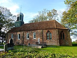
Stitswerd is a village in the municipality of Het Hogeland, Groningen, the Netherlands. It had a population of around 45 in January 2017. Stitswerd is located on a wierde near the estuary of the former river Fivel.

Hichtum is a small village in Súdwest-Fryslân municipality in the province of Friesland, the Netherlands. It had a population of around 80 in January 2017.

Groot Wetsinge and Klein Wetsinge are two villages in the municipality of Het Hogeland in the Dutch province of Groningen. The villages are less than half a kilometre apart and are often referred to together as Wetsinge. The closest village, at a distance of less than a kilometre to Wetsinge is Sauwerd.

Oostum is a wierde on the territory of Garnwerd in the municipality of Westerkwartier in the Dutch province of Groningen. The hamlet lies on the road of the city of Groningen to Garnwerd and is part of the Pieterpad.

Den Ham is a linear village in the municipality of Westerkwartier in the Netherlands province Groningen. The village lies on the road from Aduard to Saaksum.
Nijnsel is a village in the province of North Brabant, located in the Meierij of 's-Hertogenbosch. Nijnsel is a parish of the municipality of Meierijstad.

Wehe-Den Hoorn is a village in the Dutch province of Groningen. It is part of the municipality of Het Hogeland. It is a 1966 merger of the villages of Wehe and Den Hoorn.

Genhout is a village in the Dutch province of Limburg. It is located in the municipality of Beek, and consists of two former settlements: the village Groot Genhout and the hamlet Klein Genhout. Since 2005, the two settlements are no longer distinguished. It is located about 13 kilometres (8.1 mi) north-east of Maastricht.

Feerwerd is a village in the municipality of Westerkwartier in the province of Groningen in the Netherlands. As of 2021, Feerwerd had a population of 520.