Leusden is a municipality and a town in the Netherlands, in the province of Utrecht. It is located about 3 kilometres southeast of Amersfoort.
Waalre is an affluent municipality and town in the province of North Brabant in the southern Netherlands, immediately south of the city of Eindhoven.

Maldegem, earlier spelled Maldeghem, is a municipality located in the Belgian province of East Flanders. The municipality comprises the villages of Maldegem, Adegem and Middelburg. Kleit and Donk have always been separate hamlets of Maldegem. On 1 January 2018, Maldegem had a total population of 23,689. The total area is 94.64 square kilometres (36.54 sq mi) which gives a population density of 250 inhabitants per km2.

Heist-op-den-Berg is a municipality located in the Belgian province of Antwerp. The municipality comprises Heist-op-den-Berg proper, the villages of Booischot, Hallaar, Itegem, Schriek and Wiekevorst.
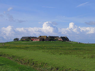
A terp, also known as a wierde, woerd, warf, warft, werf, werve, wurt or værft, is an artificial dwelling mound found on the North European Plain that has been created to provide safe ground during storm surges, high tides and sea or river flooding. The various terms used reflect the regional dialects of the North European region.

Ezinge is a village in the Dutch province of Groningen. It is located in the municipality of Westerkwartier, about 15 km northwest of the city of Groningen. Ezinge is the oldest, constantly inhabited village in The Netherlands and is in archeological context referred to as "the Pompeii of the North".

Roosteren is a village in the Dutch province of Limburg. It is located in the municipality of Echt-Susteren.

Maasdam is a village in the Dutch province of South Holland. It is located about 14 km south of the city of Rotterdam, in the municipality of Hoeksche Waard, on the rural Hoeksche Waard island. From the 14th Century until around 1800, Maasdam was also the name of the local administrative area, the fief and later the "ambacht".

Hoenderloo is a Dutch village located south west of the city of Apeldoorn. Most of the village is part of the municipality of Apeldoorn, but a small part belongs to the municipality of Ede, among which the hamlet Hoog Baarlo.

Dorkwerd is a small village in Groningen, the Netherlands. It is located in the municipality of Groningen, about 4 km northwest of the city center. Recent construction of new residential areas have brought the city to less than 500 meters from the village of Dorkwerd, and the postal authorities have placed it under Groningen.
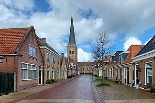
Tzum is a village in Waadhoeke municipality in the province of Friesland, the Netherlands. It had a population of around 1,110 in 2023. Tzum is known for its 72 metre tall church tower.

Broeksterwâld is a village in the Dantumadiel municipality of Friesland, in the Netherlands. In 2017, it had a population of around 1,100.

Hichtum is a small village in Súdwest-Fryslân municipality in the province of Friesland, the Netherlands. It had a population of around 80 in January 2017.

Oostum is a wierde on the territory of Garnwerd in the municipality of Westerkwartier in the Dutch province of Groningen. The hamlet lies on the road of the city of Groningen to Garnwerd and is part of the Pieterpad.

Laaxum is a hamlet in the municipality of Súdwest-Fryslân in the province of Friesland, the Netherlands.
Doodstil is a hamlet in the Dutch province of Groningen. It is a part of the municipality of Het Hogeland. The hamlet is known for its name which seemingly translates to "dead silent". Doodstil is located along the Boterdiep. In 2005, it won the election for beautiful place name of the Netherlands.

Lutten is a village in the Dutch province of Overijssel. It is located in the municipality Hardenberg, about 13 kilometres (8.1 mi) south-west of Coevorden.

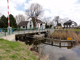
Kommerzijl, until the end of the 17th century called Opslachterzijl, is a linear village in the municipality of Westerkwartier in the province of Groningen in the Netherlands, located on the Kommerzijlsterdiep, which continues after the village as Kommerzijlsterriet and flows into the Reitdiep. To the west of the village lies the Ruigewaard and to the east the Humsterland. As of 2021, Kommerzijl had a population of 505.

Lauwerzijl is a village in the municipality of Westerkwartier in the province of Groningen in the Netherlands. As of 2021, it had a population of 195. Until 1990 the village belonged to the former municipality of Oldehove, then until 2019 to the former municipality of Zuidhorn.

Feerwerd is a village in the municipality of Westerkwartier in the province of Groningen in the Netherlands. As of 2021, Feerwerd had a population of 520.