
Appingedam is a city and former municipality in the northeastern Netherlands. Although there is no certainty as to the exact age of Appingedam, historical research demonstrates that the place in which the city would eventually be built had been inhabited for over a millennium. Specifically, the area in which the earliest traces of human settlements have been reported is the Wierde, a quarter located in the northern part of the city centre. Today, a narrow, winding street by the same name runs along the waterfront as a living testimony to the times gone by. The characteristic landmarks of the old Wierde are still recognisable today: the historical East-West Canal, called “Diep,” dug to the south of the Wierde, diked on both sides, still defines the unique layout of the downtown Appingedam.

Delfzijl is a city and former municipality with a population of 25,651 in the province of Groningen in the northeast of the Netherlands. Delfzijl was a sluice between the Delf and the Ems, which became fortified settlement in the 16th century. The fortifications were removed in the late 19th century. Delfzijl is the fifth largest seaport in the Netherlands, and the largest port in the North East of the country.

Hvar is a town and port on the island of Hvar, part of Split-Dalmatia County, Croatia. The municipality has a population of 4,251 (2011) while the town itself is inhabited by 3,771 people, making it the largest settlement on the island of Hvar. It is situated on a bay in the south coast of the island, opposite from the other nearby towns of Stari Grad and Jelsa.
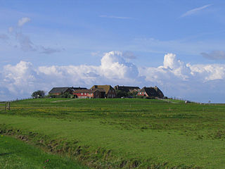
A terp, also known as a wierde, woerd, warf, warft, werf, werve, wurt or værft, is an artificial dwelling mound found on the North European Plain that has been created to provide safe ground during storm surges, high tides and sea or river flooding. The various terms used reflect the regional dialects of the North European region. In English sources, terp appears to be by far the most common term used.

Spišská Nová Ves is a town in the Košice Region of Slovakia. The town is located southeast of the High Tatras in the Spiš region, and lies on both banks of the Hornád River. It is the biggest town of the Spišská Nová Ves District.

Termunten is a village in the Dutch province of Groningen. It is a part of the municipality of Eemsdelta, and lies about 33 km east of Groningen.

Spijk is a village in the Dutch province of Groningen. It is a part of the municipality of Eemsdelta, and lies about 26 kilometres (16 mi) northeast of Groningen. Spijk is a radial terp village from 600-700 BC where the original structure is still clearly visible.

Barge is a comune (municipality) in the Province of Cuneo in the Italian region Piedmont, located about 50 kilometres (31 mi) southwest of Turin and about 45 kilometres (28 mi) northwest of Cuneo. The population numbered 7,589 as of 30 November 2019.

Stedum is a village in the Dutch province of Groningen. It is located in the municipality of Eemsdelta, about 15 km (9 mi) northeast of the city of Groningen.

St Andrew's Church is in the village of Tarvin, Cheshire, England. The church is recorded in the National Heritage List for England as a designated Grade I listed building. It is an active Anglican parish church in the diocese of Chester, the archdeaconry of Chester and the deanery of Chester. Its benefice is united with that of St Peter, Duddon.

Burdaard is a village in Noardeast-Fryslân in the province of Friesland, the Netherlands. It had a population of around 1,173 in January 2017. Before 2019, the village was part of the Ferwerderadiel municipality.

Stitswerd is a village in the municipality of Het Hogeland, Groningen, the Netherlands. It had a population of around 45 in January 2017. Stitswerd is located on a wierde near the estuary of the former river Fivel.

The Protestant church of Jistrum or Saint Peter's church is a medieval religious building in Jistrum, Friesland, Netherlands. It is a well preserved and complete 13th century Romanesque church built of red brick, located in the center of the village on Schoolstraat 2. The church is listed as a Rijksmonument, number 35645.
St Andrew's Church is a redundant Anglican church in the village of Buckland, Hertfordshire, England. It is recorded in the National Heritage List for England as a designated Grade II* listed building, and is under the care of the Churches Conservation Trust. The church stands at the highest point in the village to the east of Ermine Street, now the A10 road, between Royston and Buntingford.

Groot Wetsinge and Klein Wetsinge are two villages in the municipality of Het Hogeland in the Dutch province of Groningen. The villages are less than half a kilometre apart and are often referred to together as Wetsinge. The closest village, at a distance of less than a kilometre to Wetsinge is Sauwerd.

Obergum is part of the town Winsum that lies north of the Winsumerdiep. Originally it was a separate village. Winsum and Obergum have been connected since 1808 by the bridge De Boog.

Bellingeweer is part of the town of Winsum, in Groningen, Netherlands. Originally, it was an independent village built on a wierde. Bellingeweer had its own medieval church, which was demolished in 1824. However, the cemetery is still there.
St Andrew's Church is in the centre of the town of Penrith, Cumbria, England. It is an active Anglican parish church in the deanery of Penrith, the archdeaconry of Carlisle, and the diocese of Carlisle. The parishes of Penrith ; St John, Newton Reigny and St John the Evangelist, Plumpton Wall are united in a single benefice. The church is recorded in the National Heritage List for England as a designated Grade I listed building. At one time St Andrew's had a chapel of ease or mission church in Brougham Street in the Penrith suburb of Castletown called St Saviours and another, All Hallows at the hamlet of Bowscar just to the north of the town.

Wirdum is a village in the province of Groningen in the Netherlands. It is situated close to the Damsterdiep - a channel connecting the city of Groningen to Delfzijl - on two artificial dwelling hills, known locally as 'Wierden'. As of 2021, Wirdum had a population of 365.

The Church of St Mary the Virgin is the parish church for the village of Gamlingay in Cambridgeshire and is dedicated to St Mary the Virgin. Gamlingay is part of the ecclesiastical parish of Gamlingay with Hatley St George and East Hatley. The church is mainly 13th-century with extensive rebuilding in the 14th and 15th centuries. It has been a Grade I listed building since 1967 and comes under the St Neots Deanery in the Diocese of Ely. Nikolaus Pevsner in 1954 described the church as "... the most impressive church in this part of the county."


