Tomahawk Creek Fossicking Area, about 25 kilometres (16mi) west of Rubyvale, north-west of Emerald, is the most remote part of the Central Queensland Gemfields. It is about 2340 hectares in area, excised from a Grazing Homestead Perpetual Lease. The first huts were built in the 1960s on mining claims or under Miner's Right but in 1986 under the Mining (Fossicking) Act 1985 the area was designated a fossicking area and the huts made illegal and their residents squatters.[1]
Fossicking areas are areas where the government has negotiated access for fossickers in advance and no commercial mining is allowed. On designated fossicking lands the government has negotiated the land owners' permission in advance but some commercial mining under the appropriate legislation may occur. There are 11 designated fossicking areas in Queensland, five of them in Central Queensland, where camping with a permit for a maximum period of three months is allowed. No camping is permitted on the fossicking areas in south-east and north Queensland and there are no known huts in these areas. On the fossicking lands in western and south-west Queensland, out from Winton and Quilpie, camping with a permit is allowed for periods up to three months. There are also "general permission areas" where special conditions may apply, including Swipers Gully fossicking area near Stanthorpe, where camping is not permitted. .[1]
Houses and huts in the several townships on The Gemfields, but not at Tomahawk Creek, are now on regular titles and provided with town facilities. Tomahawk Creek is the largest fossicking area in the Gemfields.[1]
The first sapphires were found on The Central Queensland Gemfields in 1870 and attracted hand miners. Archibald John Richardson, Government Surveyor and his partner Frank Fisher, erected a treatment plant but profit eluded them. In the 1890s interest from the nobility of the Russian Empire and from German buyers stimulated the market for sapphires and a period of prosperity ensued, but these markets were lost with the onset of World War I and the Russian Revolution. Government assistance to the market kept miners on the field, with limited recovery in the 1940s. Through the years gemstone miners have lived in tents, and built huts of tin and poles, recycled materials and caravans. Small townships grew at Anakie, Sapphire, Rubyvale and The Willows.[1]
In the 1960s the price of gems increased and more tourists and gem collectors worked the fields. In 1965 machine mining began, with the first use of a bulldozer on the Gemfields. Thai buyers began visiting the fields in 1971 and output increased as heavy machinery mining became dominant, in competition and conflict with hand miners for whom some richer areas were reserved. In the late 1970s activity slowed but a core of machinery miners and hand miners remained. The Gemfields become a popular holiday destination for campers and caravanners during the cooler months.[1]
Fossicking at Tomahawk Creek was active in the late 1960s, when the earliest extant huts were built, on occupation under Mining Claims, Leases and Permits to Occupy. Most occupants stayed during winter and holiday periods; there were 13 non-permanent huts and six permanent huts in January 2007. Most of the huts began as caravans to which annexes and lean-tos were added, with walls and roofs of galvanised iron and "billy boulders" (large irregular-shaped stones of hard siliceous material) and other light materials, on frames of poles. Toilets and showers usually were built some metres distant from the hut.[1]
Designated as a fossicking area, and remote from the townships, Tomahawk Creek has not been machine mined but has been explored and mined by hand miners and tourists. The last Mining Claim expired about 1991, when two occupants applied for Permits to Occupy. There is no legal tenure of the other huts.[1]
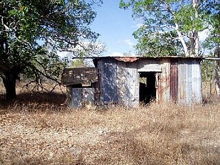
The hut known as "Tomahawk Heights" is on lot 9. It is a structure basically of galvanised iron, built after 1969 on a former camp site. There are four occasional occupants.[1]
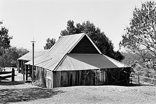
The most substantial hut in the area was built before 1984 on lot 17 by Hans and Eva Hendrickson who used a section as a shop. Known as "The Lodge", it is now occupied as a holiday place.[1]
"Camp David" hut, 2011
An A-frame hut known as "Camp David" was built at Mackay, transported to Tomahawk Creek and re-erected in Easter 1981, on Crystal Hill on lot 8. The front wall is made of coloured glass.[1]
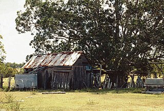
A hut of "billy boulders" and bottles, with three caravans, occupies lot 4. Its former permanent occupant (in April 2008) was relocating to a township.[1]
The regular occupants of these huts function as a community, meeting regularly and sharing services such as shopping trips and medical visits to the towns. They have a strong sense of ownership of the place and its huts, and residents care for huts when their "owners" are absent.[1]
Description
Tomahawk Creek is an area of about 2340 hectares of undulating bushland, reached at 17 kilometres (11mi) on an unsealed road, the Reklaw Park track, which leaves the Clermont Road 27 kilometres (17mi) from Rubyvale. Tomahawk Creek forms the north-western boundary. Mount Hoy is a prominent basalt peak in the south-western area. When the sign-posted entrance is reached a number of tracks run through the area, but the main one runs roughly parallel to Hut Creek where most huts are located.[1]
There were 21 huts in the area in 2006, five of which are now abandoned, ranging from five to 50 years old. Most were built around caravans with canvas annexes and roofs and walls of galvanised iron, supported by poles of bush timber, tied with wire, and recycled materials. Some are partly built of "billy boulders", especially the lower walls and outdoor barbecues. Open areas provide ventilation and cooling, with some innovative solutions to the summer heat. Three of the huts within the nominated boundary area are within about 250 metres (820ft) of each other.[1]
"The Lodge" hut, 2011
A stone hut known as "The Lodge", on lot 17, is the most substantial building in the area. It is 12-sided, a dodecahedron. The walls are made of "billy boulders", above which are horizontal logs between windows of various types using recycled materials. Around the base are air vents made from barrels with caps which can be opened to the exterior. Further ventilation is provided through the roof with slats of galvanised iron which can be opened from the inside, around the water tank that sits on the top of the roof, supported by a central pole. The roof is of galvanised iron. The hut has an electricity generator and a solar panel which charges 24 and 12 volt batteries. Inside is a wooden stove, its fireplace made from a fly wheel, and a conventional wood burning fuel stove. Similar to other huts in the area, any internal divisions are made of insubstantial materials, of hessian, scrap timber and iron.[1]
An A-frame building, known as "Camp David " on Crystal Hill, on lot 8, was built off-site and re-erected in Easter 1984. It measures approximately 9 metres (30ft) in length, 6 metres (20ft) in width and is 6 metres (20ft) high at its apex. A Trimdeck roof is supported by steel struts. It has a mezzanine sleeping area and a staircase. The floor is laid with brick pavers. Power is provided by a generator. The front wall, facing east, is made of pieces of coloured glass held in place by aluminium strips.[1]
A hut built largely of "billy boulders" and bottles occupies lot 4. Three caravans are on the site and incorporated as annexes to the hut.[1]
A hut known as "Tomahawk Heights" occupies lot 9. Building began after 1969 where the occupant had previously camped. The walls are largely of "billy boulders" but it contains the remnants of a previous building. Power is provided by a solar panel and batteries. It has a stone fireplace and barbecue.[1]
Heritage listing
Tomahawk Creek Huts was listed on the Queensland Heritage Register on 16 October 2008 having satisfied the following criteria.[1]
The place is important in demonstrating the evolution or pattern of Queensland's history.
The huts at Tomahawk Creek are important as part of the evolution of Queensland's history and particularly of the Central Region Gemfields. They illustrate a way of life associated with fossicking with minimal technology and building with recycled materials.[1]
The huts date from the 1960s with additions made in the 1980s.[1]
The place demonstrates rare, uncommon or endangered aspects of Queensland's cultural heritage.
Tomahawk Creek illustrates a way of life that has become endangered as land use that once was common has been regulated, and the solutions evident in the huts for living in difficult hot, dry climates have become rare.[1]
Camping is confined under the Fossicking Act and Regulations to fossicking areas in Central Queensland and to three fossicking areas in remote western and south-west Queensland, for periods up to three months.[1]
State government abolition of the Miner's Right on fossicking areas has resulted in a decrease in the occurrence of huts similar to those at Tomahawk Creek, and they are now rare and possibly the only survivors of an endangered tradition.[1]
Related Research Articles
A Nissen hut is a prefabricated steel structure for military use, especially as barracks, made from a half-cylindrical skin of corrugated steel. Designed during the First World War by the American-born, Canadian-British engineer and inventor Major Peter Norman Nissen, it was used also extensively during the Second World War and adapted to the similar Quonset hut in the United States.
Rubyvale is a rural town in the Central Highlands Region, Queensland, Australia. In the 2016 census, Rubyvale had a population of 640 people. It is one of three towns within the locality of The Gemfields.
Breddan Aerodrome is a heritage-listed abandoned aerodrome at Gregory Developmental Road, Breddan, Charters Towers Region, Queensland, Australia. It is located 15 kilometres (9.3 mi) north of Charters Towers. It was built from 1942 to 1943 by Allied Works Council and Queensland Main Roads Commission. The airfield was constructed for the USAAF 38th Bomb Group in August 1942 as a satellite field for Charters Towers Airport, and later used by the Royal Australian Air Force (RAAF) during World War II as a maintenance base. Consisting of two runways, the airfield was abandoned after 1948. Today, the remains of the airfield consist of some deteriorating runways, taxiways and hardstands, mostly being reclaimed by grassland and shrub. No buildings have survived. It is also known as Breddan Airfield and Breddan WWII Aircraft Maintenance, Repair and Salvage Depot. It was added to the Queensland Heritage Register on 16 April 2010.
Booby Island Light is an active heritage-listed lighthouse located on Booby Island in the Shire of Torres, near the tip of Cape York Peninsula, west of Prince of Wales Island, within the Endeavour Strait, Queensland, Australia. It marks the western entrance to the navigation channel through the Torres Strait. It was the last of the major lights to be constructed along the Queensland coast.
Double Island Point Light is an active lighthouse located at the summit of Double Island Point, a coastal headland within the Cooloola section of the Great Sandy National Park. It is located at the southern end of Wide Bay, 70 kilometres (43 mi) north of Noosa Heads, Queensland, Australia.
Commissariat Store is a heritage-listed storehouse at 115-127 William Street, Brisbane City, City of Brisbane, Queensland, Australia. It is bordered by William Street, Queen's Wharf Road and the Brisbane River, and is the birthplace of Queensland. It was designed by William John Dumaresq and built from 1828 to 1913 by convict labour under the direction of Captain Logan as a permanent Commissariat Store for the Moreton Bay penal settlement. It is also known as Government Stores, State Stores Building, and Colonial Store. It was added to the Queensland Heritage Register on 21 October 1992.
Acland No. 2 Colliery is a heritage-listed former mine at 2 Francis Street, Acland, Toowoomba Region, Queensland, Australia. It was added to the Queensland Heritage Register on 29 June 2007.
Warriston is a heritage-listed duplex at 6-8 Musgrave Road, Red Hill, City of Brisbane, Queensland, Australia. It was built c. 1886. It is also known as Berley Flats. It was added to the Queensland Heritage Register on 21 October 1992.
Slab Hut Farm is a heritage-listed farm at 847 Mt Nebo Road, Enoggera Reservoir, City of Brisbane, Queensland, Australia. It was built from 1890s to 1890s. It was added to the Queensland Heritage Register on 21 October 1992.
Penrhyn is a heritage-listed detached house at 103 Limestone Street, Ipswich, City of Ipswich, Queensland, Australia. It was designed and built by John Farrelly c. 1879. It was added to the Queensland Heritage Register on 21 October 1992.
The Selector's Hut is a heritage-listed hut at 20 Upper Camp Mountain Road, Camp Mountain, Moreton Bay Region, Queensland, Australia. It is also known as Marks' Hut. It was built c. 1870 by George Atthow. It was added to the Queensland Heritage Register on 3 December 2007.
Allan Slab Hut is a heritage-listed slab hut at Warrah Road, Duckinwilla, Fraser Coast Region, Queensland, Australia. It was built c. 1900. It is also known as Price Property. It was added to the Queensland Heritage Register on 28 April 2000.
Parson's Inn is a heritage-listed former hotel at Raglan Station Road, Raglan, Gladstone Region, Queensland, Australia. It was built from c. 1885 to 1950s. It was added to the Queensland Heritage Register on 31 July 2006.
Strathmore Homestead is a heritage-listed homestead at Strathmore Station on Strathmore Road, Springlands, Whitsunday Region, Queensland, Australia. It was built from the 1860s onward. It is also known as Strathmore Station. It was added to the Queensland Heritage Register on 13 November 2008.
Explosives Magazine and Detonator Store is a heritage-listed former gunpowder magazine at Magazine Street, Stratford, Cairns, Cairns Region, Queensland, Australia. It was built in 1901 by JC Thomson. It was added to the Queensland Heritage Register on 21 October 1992.
Wenlock Goldfield is a heritage-listed mine in Archer River, Shire of Cook, Queensland, Australia. It was built from 1892 to 1950s. It is also known as Batavia Goldfield and Lower Camp (Wenlock). It was added to the Queensland Heritage Register on 3 March 2006.
Ebagoola Township and Battery is a heritage-listed mining camp at Yarraden, Shire of Cook, Queensland, Australia. It was built from 1900 to 1913. It is also known as Ada Stewart Battery and Ebagoolah Township. It was added to the Queensland Heritage Register on 15 May 2006.
Kingsborough Battery is a heritage-listed mining building off the former East Street, Kingsborough, Thornborough, Shire of Mareeba, Queensland, Australia. It was built from c. 1896 to 1990s. It was added to the Queensland Heritage Register on 21 October 1992.
Antbed House is a heritage-listed detached house at South Street, Georgetown, Shire of Etheridge, Queensland, Australia. It was built c. 1890. It was added to the Queensland Heritage Register on 26 November 1999.
Tent House is a heritage-listed house at Fourth Street, Parkside, City of Mount Isa, Queensland, Australia. It was built c. 1930. It was added to the Queensland Heritage Register on 21 October 1992.
This page is based on this Wikipedia article Text is available under the CC BY-SA 4.0 license; additional terms may apply. Images, videos and audio are available under their respective licenses.