
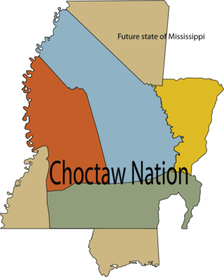
The Choctaw are a Native American people originally based in the Southeastern Woodlands, in what is now Mississippi and Alabama. The Choctaw language is a Western Muskogean language. Today, Choctaw people are enrolled in four federally recognized tribes: the Choctaw Nation of Oklahoma, Mississippi Band of Choctaw Indians, Jena Band of Choctaw Indians in Louisiana, and the Yowani Choctaws enrolled under the confederacy of the Caddo Nation. Choctaw descendants are also members of state-recognized tribes.

Mobile County is a county located in the southwestern corner of the U.S. state of Alabama. It is the third-most populous county in the state after Jefferson and Madison counties. As of the 2020 census, its population was 414,809. Its county seat is Mobile, which was founded as a deepwater port on the Mobile River. The only such port in Alabama, it has long been integral to the economy for providing access to inland waterways as well as the Gulf of Mexico.

Washington County is a county located in the southwestern part of the U.S. state of Alabama. As of the 2020 census, the population was 15,388. The county seat is Chatom. The county was named in honor of George Washington, the first President of the United States. In September 2018 The United States Office of Management and Budget (OMB) added Washington County to the Mobile, Alabama Metropolitan Statistical Area but was removed in effective July 2023.

The Chickasaw are an Indigenous people of the Southeastern Woodlands, United States. Their traditional territory was in northern Mississippi, northwestern and northern Alabama, western Tennessee and southwestern Kentucky. Their language is classified as a member of the Muskogean language family. In the present day, they are organized as the federally recognized Chickasaw Nation.
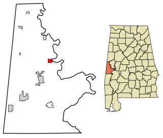
Epes is a town in Sumter County, Alabama, United States. Initially called Epes Station, it was incorporated as Epes in 1899. At the 2010 census the population was 192, down from 206 in 2000.

West Florida was a region on the northern coast of the Gulf of Mexico that underwent several boundary and sovereignty changes during its history. As its name suggests, it was formed out of the western part of former Spanish Florida, along with lands taken from French Louisiana; Pensacola became West Florida's capital. The colony included about two thirds of what is now the Florida Panhandle, as well as parts of the modern U.S. states of Louisiana, Mississippi, and Alabama.

Pinckney's Treaty, also known as the Treaty of San Lorenzo or the Treaty of Madrid, was signed on October 27, 1795, by the United States and Spain.

The Territory of Mississippi was an organized incorporated territory of the United States that was created under an organic act passed by both upper and lower chambers of the Congress of the United States, meeting at the United States Capitol on Capitol Hill, in the federal national capital city of Washington, D.C.. It was approved and signed into law by second President John Adams 1735-1826, served 1797-1801), on April 7, 1798.

The Tombigbee River is a tributary of the Mobile River, approximately 200 mi (325 km) long, in the U.S. states of Mississippi and Alabama. Together with the Alabama, it merges to form the short Mobile River before the latter empties into Mobile Bay on the Gulf of Mexico. The Tombigbee watershed encompasses much of the rural coastal plain of western Alabama and northeastern Mississippi, flowing generally southward. The river provides one of the principal routes of commercial navigation in the southern United States, as it is navigable along much of its length through locks and connected in its upper reaches to the Tennessee River via the Tennessee-Tombigbee Waterway.
The "Old Southwest" is an informal name for the southwestern frontier territories of the United States from the American Revolutionary War c. 1780, through the early 1800s, at which point the US had acquired the Louisiana Territory, pushing the southwestern frontier toward what is today known as the Southwest.

The Natchez District was one of two areas established in the Kingdom of Great Britain's West Florida colony during the 1770s – the other being the Tombigbee District. The first Anglo settlers in the district came primarily from other parts of British America. The district was recognized to be the area east of the Mississippi River from Bayou Sara in the south and Bayou Pierre in the north.

George Strother Gaines was a federal Indian agent in the Mississippi Territory. He began as the US Indian agent to the Choctaw, explored the country west of the Mississippi River, and supervised the removal of the Choctaw to Indian Territory in the 1830s. He worked as a banker, and served as a state senator and railroad lobbyist, becoming even more influential in the early history of the region.

Fort Stoddert, also known as Fort Stoddard, was a stockade fort in the U.S. Mississippi Territory, in what is today Alabama. It was located on a bluff of the Mobile River, near modern Mount Vernon, close to the confluence of the Tombigbee and Alabama Rivers. This location was just north of what was then the international boundary line between the new United States and Spanish-held West Florida. As a border fort, Fort Stoddert served as the southwestern terminus of the Federal Road which ran through Creek lands to Fort Wilkinson in Georgia. The fort, built in 1799, was named for Benjamin Stoddert, the secretary to the Continental Board of War during the American Revolution and Secretary of the Navy during the Quasi War. Fort Stoddert was built by the United States to keep the peace by preventing its own settlers in the Tombigbee District from attacking the Spanish in the Mobile District. It also served as a port of entry and was the site of a Court of Admiralty. While under the command of Captain Edmund P. Gaines, Aaron Burr was held as a prisoner at the fort after his arrest at McIntosh in 1807 for treason against the United States. In July 1813, General Ferdinand Claiborne brought the Mississippi Militia to Fort Stoddert as part of the Creek War. The 3rd Infantry Regiment was commanded by General Thomas Flournoy to Fort Stoddert following the Fort Mims massacre. The site declined rapidly in importance after the capture of Mobile by the United States in 1813 and the establishment of the Mount Vernon Arsenal in 1828.

Mushulatubbee was the chief of the Choctaw Okla Tannap, one of the three major Choctaw divisions during the early 19th century. When the Principal Chief Greenwood LeFlore stayed in Mississippi at the time of removal, Mushulatubbee was elected as principal chief, leading the tribe to Indian Territory.
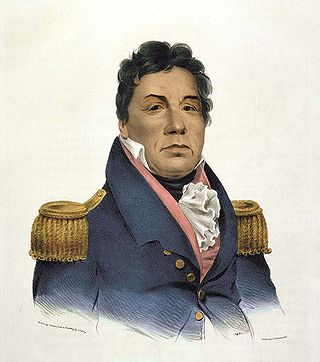
Pushmataha was one of the three regional chiefs of the major divisions of the Choctaw in the 19th century. Many historians considered him the "greatest of all Choctaw chiefs". Pushmataha was highly regarded among Native Americans, Europeans, and white Americans, for his skill and cunning in both war and diplomacy.
The Chickasaw Wars were fought in the first half of the 18th century between the Chickasaw allied with the British against the French and their allies the Choctaws, Quapaw, and Illinois Confederation. The Province of Louisiana extended from Illinois to New Orleans, and the French fought to secure their communications along the Mississippi River. The Chickasaw, dwelling in northern Mississippi and western Tennessee, lay across the French path. Much to the eventual advantage of the British and the later United States, the Chickasaw successfully held their ground. The wars came to an end only with the French cession of New France to the British in 1763 according to terms of the Treaty of Paris.

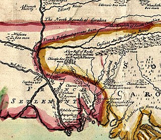
Fort Tombecbe, also spelled Tombecbee and Tombeché, was a stockade fort located on the Tombigbee River near the border of French Louisiana, in what is now Sumter County, Alabama. It was constructed under the leadership of Jean-Baptiste Le Moyne, Sieur de Bienville in 1736–1737 as trading post about 270 miles (430 km) upriver from Mobile, on an 80-foot (24 m) limestone bluff. Fort Tombecbe was built in Choctaw lands and would play a major role in colonial France's efforts to stop British intrusions into the area. Bienville claimed that the new fort was to protect the Choctaw from the Chickasaw. In May of 1736, Bienville, along with a force of 600 soldiers combined with a force of 600 Choctaw warriors, set out from Fort Tombecbe and attacked the Chickasaw near present-day Tupelo, Mississippi at the Battle of Ackia. Tombecbe was a major French outpost and trade depot among the Choctaw, the largest Native American group in the colony.
The Treaty of Mount Dexter was signed between the United States and the Choctaws. The treaty was signed November 16, 1805. The 4,142,720-acre (16,765.0 km2) area ceded was from the Natchez District to the Tombigbee Alabama River watershed, mostly in present-day Mississippi.
The Choctaw Corner is a former Native American boundary location near the modern border between Clarke and Marengo counties in Alabama, United States. It was established as the northernmost terminus for a mutually agreed upon boundary line between the Choctaw and Creek peoples during the Mississippi Territory period. This boundary line, now known as the “Old Indian Treaty Boundary,” starts at the Alabama River cut-off in southernmost Clarke County and follows a northward path through the county along the drainage divide between the Tombigbee and Alabama rivers to the Choctaw Corner, then turns ninety degrees to the west and follows the modern county-line between Clarke and Marengo to the Tombigbee River.
Simon Favre was an interpreter of the Muskogean languages, particularly Choctaw and Chickasaw, for the French, British, Spanish and Americans in the part of West Florida that became part of the states of Mississippi and Alabama. The son of another prominent interpreter, Favre spent the late 18th century in the vicinity of Mobile and the Tombigbee River, which changed hands from French to British, and then Spanish control. He became well versed in the language and culture of the Choctaws, and was involved with several treaties between the Europeans and natives. As a young man he had a Choctaw mistress with whom he had six known children, then at the age of 41 he was legally married in Mobile to a woman of European descent. Within a few years of his marriage, he moved with his new family from the Tombigbee area to a plantation on the Pearl River.
