McIntosh, Alabama

Last updated

McIntosh, Alabama
Andrews Chapel, McIntosh, Alabama LCCN2010640222.tif
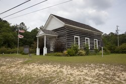
Andrews Chapel in McIntosh
Washington County Alabama Incorporated and Unincorporated areas McIntosh Highlighted 0145472.svg
Location of McIntosh in Washington County, Alabama.
Coordinates: 31°15′58″N88°1′53″W / 31.26611°N 88.03139°W / 31.26611; -88.03139
Country United States
State Alabama
County Washington
Area
[1]
  Total1.00 sq mi (2.58 km2)
  Land1.00 sq mi (2.58 km2)
  Water0.00 sq mi (0.00 km2)
Elevation
49 ft (15 m)
Population
 (2020)
  Total206
  Density206.83/sq mi (79.85/km2)
Time zone UTC-6 (Central Time (CT))
  Summer (DST) UTC-5 (CDT)
ZIP code
36553
Area code 251
FIPS code 01-45472
GNIS feature ID0152280
Website mcintoshal.com

McIntosh, (originally known as McIntosh Bluff [2] ), is a town located in Washington County, Alabama, United States along U.S. Route 43. It is 12+12 miles (20.1 km) south of Wagarville and 44 miles (71 km) north of Mobile. The population as of the 2020 U.S. Census was 206, down from 238 in 2010.

Contents

McIntosh is one of the most Native American towns in Alabama, with over half of the town's inhabitants reporting to be of Native descent in the 2020 census

The town and county have a high proportion of residents who are members of the MOWA Band of Choctaw Indians, a state-recognized tribe of people of the Muskogean-speaking language family. It has one site, Andrews Chapel, listed on the National Register of Historic Places. [3]

History

McIntosh was named for Captain John McIntosh, a British Army officer. [2] McIntosh had a river landing at McIntosh Bluff on the Tombigbee River. [4] The town was incorporated on April 7, 1970. [5] McIntosh is near the site of Aaron Burr's arrest in 1807 while the area was part of the Mississippi Territory. He was captured by U.S. Army Lt. Edmund P. Gaines in the town of Wakefield, a few miles to the north, and then confined to Fort Stoddert. A historic marker has been placed to document this event. [6]

Geography

McIntosh is located at 31°15'58" North, 88°1'53" West (31.265979, -88.031473). [7] According to the U.S. Census Bureau, the town has a total area of 1.0 square mile (2.6 km2), all land.

Demographics

Historical population
CensusPop.Note
1970 297
1980 3197.4%
1990 250−21.6%
2000 244−2.4%
2010 238−2.5%
2020 206−13.4%
U.S. Decennial Census [8]
2013 Estimate [9]

As of the census of 2000, [10] there were 244 people, 94 households and 62 families in the town. The population density was 243.9 inhabitants per square mile (94.2/km2). There were 98 housing units at an average density of 98.0 per square mile (37.8/km2). The racial makeup of the town was 55.23% Native American, 43.03% Black or African American, 1.33% White and 0.41% from two or more races. 0,41% of the population were Hispanic or Latino of any race.

There were 94 households, out of which 36.2% had children under the age of 18 living with them, 47.9% were married couples living together, 18.1% had a female householder with no husband present, and 33.0% were non-families. 30.9% of all households were made up of individuals, and 11.7% had someone living alone who was 65 years of age or older. The average household size was 2.60 and the average family size was 3.27.

In the town, the population was spread out, with 29.5% under the age of 18, 6.6% from 18 to 24, 24.6% from 25 to 44, 25.0% from 45 to 64, and 14.3% who were 65 years of age or older. The median age was 35 years. For every 100 females, there were 83.5 males. For every 100 females age 18 and over, there were 72.0 males.

The median income for a household in the town was $28,214, and the median income for a family was $39,167. Males had a median income of $31,429 versus $22,750 for females. The per capita income for the town was $14,023. 13.5% of the population and 10.0% of families were below the poverty line. Out of the total population, 22.2% of those under the age of 18 and 9.1% of those 65 and older were living below the poverty line.

Notable people


Related Research Articles

<span class="mw-page-title-main">Chambers County, Alabama</span> County in Alabama, United States

Chambers County is a county located in the east central portion of the U.S. state of Alabama. As of the 2020 census the population was 34,772. Its county seat is LaFayette. Its largest city is Valley. Its name is in honor of Henry H. Chambers, who served as a United States Senator from Alabama.

<span class="mw-page-title-main">Lamar County, Alabama</span> County in Alabama, United States

Lamar County is a county in the U.S. state of Alabama. As of the 2020 census, the population was 13,972. Its county seat is Vernon and it is a dry county. It is named in honor of Lucius Quintus Cincinnatus Lamar, a former Confederate officer and former member of both houses of the United States Congress from Mississippi.

<span class="mw-page-title-main">Randolph County, Alabama</span> County in Alabama, United States

Randolph County is a county on the central eastern border of the U.S. state of Alabama. As of the 2020 census, the population was 21,967. Its county seat is Wedowee. Its name is in honor of John Randolph, a member of the United States Senate from Virginia. Randolph County was a prohibition or dry county until 2012, when the citizens of Randolph County voted to repeal prohibition.

<span class="mw-page-title-main">Midway, Alabama</span> Town in Alabama, United States

Midway is a town located in eastern Bullock County, Alabama, United States. At the 2020 census, the population was 421.

<span class="mw-page-title-main">Toxey, Alabama</span> Town in Alabama, United States

Toxey is a town in Choctaw County, Alabama, United States. At the 2020 census, the population was 145.

<span class="mw-page-title-main">Babbie, Alabama</span> Town in Alabama, United States

Babbie is a town in Covington County, Alabama, United States. At the 2020 census, the population was 625. It incorporated in 1957.

<span class="mw-page-title-main">Boligee, Alabama</span> Town in Alabama, United States

Boligee is a town in Greene County, Alabama, United States. Per the 2020 census, the population was 301. Although Boligee appeared on the 1880 U.S. Census, according to the 1930 U.S. Census it did not incorporate until 1926, though another source cited 1927.

<span class="mw-page-title-main">Forkland, Alabama</span> Town in Alabama, United States

Forkland is a town in Greene County, Alabama, United States. At the 2020 census, the population was 445. It was incorporated around 1974.

<span class="mw-page-title-main">Stevenson, Alabama</span> City in Alabama, United States

Stevenson is a city in Jackson County, Alabama, United States, and is included in the Chattanooga-Cleveland-Dalton, TN-GA-AL Combined Statistical Area. Sources listed either 1866 or 1867 as the year of incorporation, but that seems to conflict with the dates given for the town being granted a charter. It did not first appear on the U.S. Census until 1880, where it was the second largest town in Jackson County behind Scottsboro. Since 1900, it has been the third largest town behind either Scottsboro and Bridgeport or vice versa. At the 2020 census, the population of the city was 1,955, down from 2,046 in 2010.

<span class="mw-page-title-main">Homewood, Alabama</span> City in Alabama, United States

Homewood is a city in southeastern Jefferson County, Alabama, United States. It is a suburb of Birmingham, located on the other side of Red Mountain due south of the city center. The population was 26,414 at the 2020 census.

<span class="mw-page-title-main">Sulligent, Alabama</span> City in Alabama, United States

Sulligent is a city in Lamar County, Alabama, United States. As of the 2010 census, the population of the city was 1,927, down from its record high of 2,151 in 2000. From 1910-1950 and again in 2000, it was the largest community in Lamar County before losing the distinction both times to the county seat of Vernon. The name is derived from railroad personnel.

<span class="mw-page-title-main">Mount Vernon, Alabama</span> Town in Alabama, United States

Mount Vernon is a town in Mobile County, Alabama, United States. It is part of the Mobile metropolitan area. It incorporated in 1959. At the 2020 census the population was 1,354.

<span class="mw-page-title-main">McMullen, Alabama</span> Town in Alabama, United States

McMullen is a town in Pickens County, Alabama, United States. It incorporated around 1976. A series of natural disasters has caused the population to dwindle. As of 2010, it was the smallest incorporated town in the state of Alabama. It was overtaken by Oak Hill in 2020. The population was 32 at the 2020 United States census, up from 10 in 2010.

<span class="mw-page-title-main">Pickensville, Alabama</span> Town in Alabama, United States

Pickensville is a rural town in Pickens County, Alabama, United States. At the 2010 census the population was 608, down from 662 in 2000. It was initially incorporated in 1839 and briefly served before that as the first county seat of Pickens County. Carrollton was designated as the seat in the early 1830s.

<span class="mw-page-title-main">Camden, Alabama</span> City in and county seat of Wilcox County, Alabama

Camden is a city in and the county seat of Wilcox County, Alabama, United States. The population was 2,020 at the 2010 census, down from 2,257 in 2000, at which time it was a town.

<span class="mw-page-title-main">Whitesburg, Georgia</span> Town in Georgia, United States

Whitesburg is a town in Carroll County, Georgia, United States. The population was 588 at the 2010 census.

<span class="mw-page-title-main">McIntosh, Minnesota</span> City in Minnesota, United States

McIntosh is a city in Polk County, Minnesota, United States. It is part of the Grand Forks, ND-MN Metropolitan Statistical Area. The population was 606 at the 2020 census.

<span class="mw-page-title-main">Fulton, Mississippi</span> City in Mississippi, United States

Fulton is a city in and the county seat of Itawamba County, Mississippi, United States. The population was 4,542 at the 2020 census.

<span class="mw-page-title-main">Surry, Virginia</span> Town in Virginia, United States

Surry is an incorporated town in Surry County, Virginia, United States. The population was 244 at the 2010 census. It is the county seat of Surry County. Its name is derived from the historic county of Surrey in England.

<span class="mw-page-title-main">Troup, Texas</span> City in Texas, United States

Troup is a city in Smith and Cherokee Counties in the U.S. state of Texas. Its population was 2,006 at the 2020 census. Troup lies in two counties in East Texas.

References

  1. "2020 U.S. Gazetteer Files". United States Census Bureau. Retrieved October 29, 2021.
  2. 1 2 Kaetz, James P. "McIntosh". Encyclopedia of Alabama. Retrieved September 21, 2023.
  3. "National Register Information System". National Register of Historic Places . National Park Service. March 13, 2009.
  4. "National Register of Historic Places Multiple Property Documentation Form". Department of the Interior. Retrieved September 19, 2023.
  5. "Town of McIntosh, Alabama". mcintoshal.com.
  6. "Alabama Historical Marker Program-Washington County". Archived from the original on February 22, 2013. Retrieved December 30, 2012.
  7. "US Gazetteer files: 2010, 2000, and 1990". United States Census Bureau. February 12, 2011. Retrieved April 23, 2011.
  8. "U.S. Decennial Census". Census.gov. Retrieved June 6, 2013.
  9. "Annual Estimates of the Resident Population: April 1, 2010 to July 1, 2013" . Retrieved June 3, 2014.
  10. "U.S. Census website". United States Census Bureau . Retrieved January 31, 2008.
  11. Saba, Natalie. "George Troup". New Georgia Encyclopedia. Retrieved September 21, 2023.

31°15′58″N88°01′53″W / 31.265979°N 88.031473°W / 31.265979; -88.031473