Toolesboro, Iowa

Last updated

Toolesboro, Iowa
Toolesboro mounds.jpg
USA Iowa location map.svg
Red pog.svg
Toolesboro
Usa edcp location map.svg
Red pog.svg
Toolesboro
Coordinates: 41°08′31″N91°03′44″W / 41.14194°N 91.06222°W
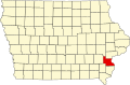
 / 41.14194; -91.06222
Country United States
State Iowa
County Louisa
Township Jefferson
Elevation
[1]
682 ft (208 m)
Time zone UTC-6 (Central (CST))
  Summer (DST) UTC-5 (CDT)
Area code 319
GNIS feature ID462278 [1]

Toolesboro is an unincorporated community in southeastern Louisa County, Iowa, United States.

The community is on Iowa Route X99 approximately seven miles southeast of Wapello and the Iowa River passes just to the east. [2]

History

Toolsboro is shown on the 1903 Louisa County, Iowa, map Louisa County Iowa 1903.png
Toolsboro is shown on the 1903 Louisa County, Iowa, map

The Toolesboro Mound Group, a National Historic Landmark, lies north of the community. [2]

Toolesboro was platted circa 1837 by William L. Toole. [3]

References

  1. 1 2 "Toolesboro". Geographic Names Information System . United States Geological Survey, United States Department of the Interior.
  2. 1 2 Iowa Atlas & Gazetteer, DeLorme, 7th Edition, 2021 pp. 56-7 ISBN   1946494003
  3. Springer, Arthur (1912). History of Louisa County, Iowa, from Its Earliest Settlement to 1912, Volume 1. S. J. Clarke Publishing Company. p. 291.