Platner's map of Rome for The Topography and Monuments of Ancient Rome (1911).
The topography of ancient Rome is the description of the built environment of the city of ancient Rome. It is a multidisciplinary field of study that draws on archaeology, epigraphy, cartography and philology. The word 'topography' here has its older sense of a description of a place,[1] now often considered to be local history,[2] rather than its usual modern meaning, the study of landforms.
The classic English-language work of scholarship is A Topographical Dictionary of Ancient Rome (1929), written by Samuel Ball Platner, completed and published after his death by Thomas Ashby. New finds and interpretations have rendered many of Platner and Ashby's conclusions unreliable, but when used with other sources the work still offers insights and complementary information.
In 1992, Lawrence Richardson published A New Topographical Dictionary of Ancient Rome, which builds on Platner and Ashby.[3] The six-volume, multilingual Lexicon Topographicum Urbis Romae (1993‑2000) is the major modern work in the field.
Among the early topographers of ancient Rome were the 15th-century humanists Poggio Bracciolini and Flavio Biondo. Poggio's De varietate fortunae ("On the Vagaries of Fortune") was a nostalgic and moralizing evocation of a lost Rome of triumphs, spectacles, and grand monuments, but it also contained detailed descriptions of temples, baths, arches, amphitheaters and other landmarks as artifacts subject to intellectual inquiry, in contrast to medieval mirabilia literature.[5] Poggio researched ancient texts such as Frontinus's work On the Water Supply of the City of Rome and examined inscriptions, compiling a volume of epigraphy from ancient monuments: "Through such diligence, Poggio pioneered the way to reconstruct in historically accurate terms the topographical reality of the ancient city."[6]
Biondo, like Poggio an Apostolic Secretary, produced a series of volumes surveying the topography of the ancient city as well as Roman Italy: Roma instaurata (1440–46), Italia illustrata (1448–53), and Roma triumphans (1456–60). In these works, Biondo took an antiquarian or archaeological approach, as distinguished from his historical writing in the Decades which influenced Gibbon.[7]
He organized his material by topic, and not only described and identified gates, obelisks, baths, circuses, and other monuments, but explained their function and purpose. Among his literary and documentary sources were Livy's history of Rome, the letters of Pliny, Varro's De lingua latina, Festus, the regionary catalogues, and the newly discovered manuscripts of Tacitus and Frontinus.[8]
Although Renaissance researchers did not engage in archaeological digs, the archaeological and topographical perspective was fundamental to humanism, and they were alert to finds of antiquities. Biondo, for instance, was able to locate the atrium of the Theater of Pompey after a Roman lawyer who was having his wine cellar enlarged found a massive block of dressed stone inscribed with cubit-high letters reading Genius theatri Pompeiani.[9]
Biondo's methodology and use of textual sources influenced the archaeological, antiquarian, and topographical study of ancient Rome among his fellow humanists for the next 80 years. Among these were Pomponius Leto, who edited the Notitia regionum Urbis based in part on his experience as a tour guide; Bernardo Rucellai, with his compilation De Urbe Roma; and Andrea Fulvio, who published his massive Antiquitates Urbis in the spring of 1527, just before the sack.[10] The successor to Biondo's work was the seven-volume Antiquae Romae topographia of Bartolomeo Marliani, first published in May 1534,[11] but riddled with typographical errors. Bartolomeo credited the collaboration of various scholars, singling out Annibale Caro. The work was republished in a corrected, augmented second edition in 1544, as Urbis Romae topographia and rededicated, this time to Francis I of France. It was this second edition that was often reprinted, complete and in epitomes, and translated into the modern languages of Europe. But the first edition was the basis for an edition published the same year at Lyon, that was thoroughly revised and augmented by François Rabelais and dedicated to Jean du Bellay, with whom Rabelais had been staying in Rome in March through April 1534, just before Marliani's Topographia appeared; it would appear that Rabelais had contact with Marliani.[12]
↑ This is the assessment of Bill Thayer, a private scholar whose LacusCurtius site has been an online resource for ancient Rome since 1997. For a perspective on Richardson's book for the general reader, see Thayer's review.
↑ Overview based on J.G.A. Pocock, Barbarism and Religion: The First Decline and Fall (Cambridge University Press, 2003, 2005), p. 181ff., and Charles L. Stinger, The Renaissance in Rome (Indiana University Press, 1985, 1998), p. 61ff.
↑ Harry B. Evans, Aqueduct Hunting in the Seventeenth Century: Raffaello Fabretti's De aquis et aquaeductibus veteris Romae (University of Michigan Press, 2002), p. 13.
d'Ambra, Eve, 2009. "Topography of Rome", Oxford Bibliographiesonline
Aicher, Peter J. 2004. Rome Alive: A Source-Guide to the Ancient City. 2 vols. Wauconda, IL: Bolchazy-Carducci.
Ammerman, Albert. 1990. "On the Origins of the Roman Forum." American Journal of Archaeology 94:627–645.
Ball, Larry F. 2003. The Domus Aurea and the Roman Architectural Revolution. Cambridge, UK and New York: Cambridge Univ. Press.
Boatwright, Mary T. 1987. Hadrian and the City of Rome. Princeton: Princeton Univ. Press.
Claridge, Amanda. 1998. Rome: An Oxford Archaeological Guide to Rome. Oxford: Oxford Univ. Press.
Haselberger, Lothar and John Humphrey, eds. 2006. Imaging Ancient Rome: Documentation, Visualization, Imagination. Proceedings of the Third Williams Symposium on Classical Architecture, May 20–23, 2004, supp. 61. Portsmouth, RI: Journal of Roman Archaeology.
Kantor-Kazovsky, Lola. 2006. Piranesi as Interpreter of Roman Architecture and the Origins of his Intellectual World. Florence: L. S. Olschki.
Purcell, Nicholas. 1987. "Tomb and Suburb." In Römische gräberstrassen: Selbstdarstellungen, status, standard. Edited by Henner von Hesberg and Paul Zanker, 25–41. Munich: Verlag der Bayerischen Akademie der Wissenschaften
Richardson, Lawrence, Jr. 1992. A New Topographical Dictionary of Ancient Rome. Baltimore: Johns Hopkins Univ. Press.
Taylor, Rabun M. 2000. Public Needs and Private Pleasures: Water Distribution, the Tiber River, and the Urban Development of Ancient Rome. Rome: L’Erma di Bretschneider.
Rodolfo Amedeo Lanciani was an Italian archaeologist, a pioneering student of ancient Roman topography. Among his many excavations was that of the House of the Vestals in the Roman Forum.
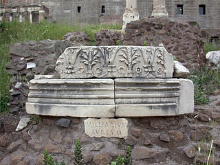
The Milliarium Aureum, also known by the translation Golden Milestone, was a monument, probably of marble or gilded bronze, erected by the Emperor Augustus near the Temple of Saturn in the central Forum of Ancient Rome. All roads were considered to begin at this monument and all distances in the Roman Empire were measured relative to it. On it perhaps were listed all the major cities in the empire and distances to them, though the monument's precise location and inscription remain matters of debate among historians.
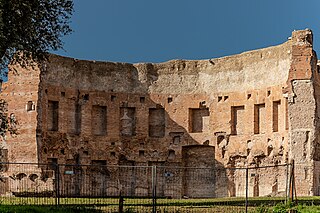
The Baths of Trajan were a massive thermae, a bathing and leisure complex, built in ancient Rome and dedicated under Trajan during the kalendae of July 109, shortly after the Aqua Traiana was dedicated.
A Topographical Dictionary of Ancient Rome is a reference work written by Samuel Ball Platner (1863–1921). The first edition was published in 1904; the second edition was published in 1911 . The book was completed by Thomas Ashby after Platner's death and published in 1929 by Oxford University Press. Referred to as 'Platner and Ashby', the volume describes the ancient monuments and buildings in the city of Rome, although by and large only if they belong to the classical period. It covers both remains that are still extant and buildings of which not a trace remained, and collates source documents for each. This volume was, for fifty or sixty years, the standard reference in the field of Roman topography, having superseded Rodolfo Lanciani's Forma Urbis Romae (1893‑1901). Platner and Ashby has since itself been superseded by a reworking, L. Richardson, Jr.'s A New Topographical Dictionary of Ancient Rome, but mostly by the new standard, a completely new work, Margareta Steinby's Lexicon Topographicum Urbis Romae.
Mirabilia Urbis Romae is a much-copied medieval Latin text that served generations of pilgrims and tourists as a guide to the city of Rome. The original, which was written by a canon of St Peter's, dates from the 1140s. The text survives in numerous manuscripts.
The Saepta Julia was a building in the Campus Martius of Rome, where citizens gathered to cast votes. The building was conceived by Julius Caesar and dedicated by Marcus Vipsanius Agrippa in 26 BCE. The building replaced an older structure, called the Ovile, built as a place for the comitia tributa to gather to cast votes. The Saepta Julia can be seen on the Forma Urbis Romae, a map of the city of Rome as it existed in the early 3rd century CE. Part of the original wall of the Saepta Julia can still be seen right next to the Pantheon.
The Temple of Antoninus and Faustina is an ancient Roman temple in Rome, which was later converted into a Roman Catholic church, the Chiesa di San Lorenzo in Miranda or simply "San Lorenzo in Miranda". It is located in the Forum Romanum, on the Via Sacra, opposite the Regia.
Thomas Ashby, was a British archaeologist and director of the British School at Rome.
Porta Pinciana is a gate of the Aurelian Walls in Rome.
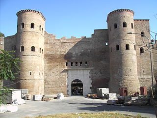
The Porta Asinaria is a gate in the Aurelian Walls of Rome. Dominated by two protruding tower blocks and associated guard rooms, it was built between 271 and 275 AD, at the same time as the Wall itself. It was not rebuilt or fortified in the time of Honorius and not restored by Theoderic as most of the other gates.
The Aqua Marcia is one of the longest of the eleven aqueducts that supplied the city of Rome. The aqueduct was built between 144–140 BC, during the Roman Republic. The still-functioning Acqua Felice from 1586 runs on long stretches along the route of the Aqua Marcia.
Porta Metronia is a gate in the third-century Aurelian Walls of Rome, Italy. The gate is located in the southern section of the wall between Porta San Giovanni to the east and Porta Latina to the south.
The Pons Neronianus or Bridge of Nero was an ancient bridge in Rome built during the reign of the emperors Caligula or Nero to connect the western part of the Campus Martius with the Ager Vaticanus, where the Imperial Family owned land along the Via Cornelia.
Francesco Albertini was a canon of the Basilica of San Lorenzo in Florence and a chaplain of Cardinal Fazio Santoro in Rome. In 1510 he wrote three books: The Opusculum de mirabilibus novae & veteris urbis Romae, the Septem mirabilia orbis et urbis Romae et Florentinae and the Memoriale di molte picture e statue sono nella inclyta cipta di Florentia.
The Lexicon Topographicum Urbis Romae (1993–2000) is a six-volume, multilingual reference work considered to be the major, modern work covering the topography of ancient Rome. The editor is Eva Margareta Steinby, and the publisher is Edizioni Quasar of Rome. It is considered the successor to Platner and Ashby's A Topographical Dictionary of Ancient Rome.
Porta Ardeatina was one of the gates of the Aurelian Walls in Rome (Italy).
The Temple of Jupiter Tonans was a small temple in Rome, dedicated by Augustus Caesar in 22 BCE to Jupiter, the chief god of ancient Rome. It was probably situated at the entrance to the Area Capitolina, the sanctuary of Jupiter on the Capitoline Hill, near the much older and larger Temple of Jupiter Optimus Maximus. The temple was considered among Augustus's most impressive archaeological projects, and played an important role in the Secular Games, a religious and artistic festival that he revived in 17 BCE. It was also noted by Roman authors for the artworks, particularly statues, displayed in and around it.
The Temple of the Flavian clan was a Roman temple on the Quirinal Hill, dedicated by Domitian at the end of the 1st century to other members of the Flavian dynasty. It was sited at the ad Malum Punicum, on a site near the present-day junction of Via XX Settembre and Via delle Quattro Fontane. This site was near the residences of Vespasian and Vespasian's brother Titus Flavius Sabinus.
The Arch of Pietas was an ancient Roman triumphal arch to the north of the Pantheon on the Campus Martius in Rome.
Giovanni Bartolomeo Marliano was an Italian antiquarian and topographer, most notable for his study of the topography of ancient Rome, particularly his seven-volume Antiquae Romae topographia, a complete treatment of the city's ancient topography. First published in 1534 and republished nine times, it remained the standard treatise on the city's topography until the 18th century. He lost a debate with Pirro Ligorio on the site of the Roman Forum, but was later proved right in that matter.
This page is based on this Wikipedia article Text is available under the CC BY-SA 4.0 license; additional terms may apply. Images, videos and audio are available under their respective licenses.