
The Appian Way is one of the earliest and strategically most important Roman roads of the ancient republic. It connected Rome to Brindisi, in southeast Italy. Its importance is indicated by its common name, recorded by Statius, of Appia longarum... regina viarum . The road is named after Appius Claudius Caecus, the Roman censor who began and completed the first section as a military road to the south in 312 BC during the Samnite Wars.
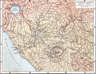
The Aniene, formerly known as the Teverone, is a 99-kilometer (62 mi) river in Lazio, Italy. It originates in the Apennines at Trevi nel Lazio and flows westward past Subiaco, Vicovaro, and Tivoli to join the Tiber in northern Rome. It formed the principal valley east of ancient Rome and became an important water source as the city's population expanded. The falls at Tivoli were noted for their beauty. Historic bridges across the river include the Ponte Nomentano, Ponte Mammolo, Ponte Salario, and Ponte di San Francesco, all of which were originally fortified with towers.

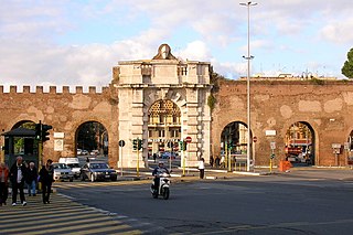
The Aurelian Walls are a line of city walls built between 271 AD and 275 AD in Rome, Italy, during the reign of the Roman Emperor Aurelian. They superseded the earlier Servian Wall built during the 4th century BC.

Aqua Anio Novus was an ancient Roman aqueduct supplying the city of Rome. Like the Aqua Claudia, it was begun by emperor Caligula in 38 AD and completed in 52 AD by Claudius, who dedicated them both on August 1.

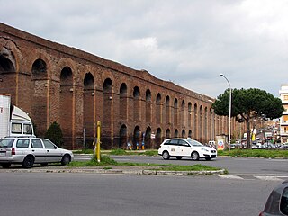
Aqua Claudia was an ancient Roman aqueduct that, like the Aqua Anio Novus, was begun by Emperor Caligula in 38 AD and finished by Emperor Claudius in 52 AD.

The Arch of Drusus is an ancient arch in Rome, Italy, close to the First Mile of the Appian Way and next to the Porta San Sebastiano. Long misidentified, it is most likely the remains of the Arch of Trajan.

The Aqua Julia is a Roman aqueduct built in 33 BC by Agrippa under Augustus to supply the city of Rome. It was repaired and expanded by Augustus from 11–4 BC.

The Acqua Felice is one of the aqueducts of Rome, completed in 1586 by Pope Sixtus V, whose birth name, which he never fully abandoned, was Felice Peretti. The first new aqueduct of early modern Rome, its source is at the springs at Pantano Borghese, off Via Casilina. Its length is fifteen miles (24 km), running underground for eight miles (13 km) from its source, first in the channel of Aqua Alexandrina, then alternating on the arches of the Aqua Claudia and the Aqua Marcia for seven miles (11 km) to its terminus at the Fontana dell'Acqua Felice on the Quirinal Hill, standing to one side of the Strada Pia, so as to form a piazza in this still new part of Rome. The engineer was Giovanni Fontana, brother of Sixtus' engineer-architect Domenico Fontana, who recorded that the very day the new pope entered the Lateran, he decided that he would bring water once again to the hills of Rome, which had remained waterless and sparsely inhabited, largely by monasteries, since the original ancient aqueducts had been destroyed in the sixth century. From the source, which Sixtus purchased, there was only a very small fall, and the work required an underground conduit as well as an aqueduct carried on arches.

The Aqua Tepula is an ancient Roman aqueduct completed in 125 BC by censors Gnaeus Servilius Caepio, who had served as consul in 141 BC, and Lucius Cassius Longinus Ravilla.

The Caffarella Park is a large park in Rome, Italy, protected from development. It is part of the Parco Regionale Appia Antica. The park is contained in the Caffarella Valley and is bordered on its northern side by the Via Latina and on its southern by the Appian Way. It stretches from the main Rome-Pisa railroad tracks near the Aurelian Wall at its western edge to the Via dell'Almone to the east. It contains several sites of archaeological interest, as well as a working farm, and has considerable ecological value, with 78 species of birds and fauna. The Catacombs of Rome and Colli Albani are nearby.

The Parco degli Acquedotti is a public park to the southeast of Rome, Italy. It is part of the Appian Way Regional Park and is of approximately 240 ha.
The Aqua Alexandrina was a Roman aqueduct located in the city of Rome. The 22.4 km long aqueduct carried water from Pantano Borghese to the Baths of Alexander on the Campus Martius. It remained in use from the 3rd to the 8th century AD.

The Aqua Marcia is one of the longest of the eleven aqueducts that supplied the city of Rome. The aqueduct was built between 144–140 BC, during the Roman Republic. The still-functioning Acqua Felice from 1586 runs on long stretches along the route of the Aqua Marcia.
The Appian Way Regional Park is the second-largest urban park of Europe, after Losiny Ostrov National Park in Moscow. It is a protected area of around 4580 hectares, established by the Italian region of Latium. It falls primarily within the territory of Rome but parts also extend into the neighbouring towns of Ciampino and Marino.

The Aqua Anio Vetus was an ancient Roman aqueduct, and the second oldest after the Aqua Appia.

Aqueduct near Rome is an 1832 oil painting by the English-born American artist Thomas Cole. It measures 44.5 in × 67.3 in and is the largest painting that Cole completed during his first visit to Italy in 1831–32.

Municipio Roma VII is the seventh administrative subdivision of the Municipality of Rome (Italy).
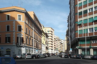
Tuscolano is the 8th quartiere of Rome (Italy), identified by the initials Q. VIII. The name derives from the ancient road Via Tuscolana. It belongs to the Municipio V and Municipio VII.
Appio-Latino is the 9th quartiere of Rome (Italy), identified by the initials Q. IX. The name derives from the ancient roads Via Appia and Via Latina. It belongs to the Municipio VII and Municipio VIII.

