Torrenova (Rome)

Last updated
Torrenova
Zona of Rome
Eindpunt Giardinetti.jpg
The terminus of the Rome-Giardinetti railway.
Roma Zona XVI - Torrenova.png
Position of the zona within the city
CountryFlag of Italy.svg  Italy
Region Lazio
Province Rome
Comune Rome
Area
  Total2.8339 sq mi (7.3397 km2)
Population
 (2016) [1]
  Total29,563
  Density10,432.0/sq mi (4,027.82/km2)
Time zone UTC+1 (CET)
  Summer (DST) UTC+2 (CEST)

Torrenova is the 16th zona of Rome, identified by the initials Z. XVI. It belongs partly to the Municipio VI and partly to the Municipio VII.

Contents

Geography

The territory of Torrenova includes the urban zone 10GRomanina and the western part of the urban zones 8CGiardinetti-Tor Vergata and 10IBarcaccia.

Boundaries

Torrenova borders to the north with Zona Torre Angela (Z. XIII), from which is separated by the stretch of Via Casilina between the GRA and Via di Tor Vergata.

To the east, the zone borders with Zona Torre Gaia (Z. XVII), whose boundary is marked by the whole Via di Tor Vergata.

Southward, the zone borders with Zona Casal Morena (Z. XIX), from which is separated by the stretch of Via Tuscolana between Via di Tor Vergata and the GRA.

Westward, Torrenova borders with Zona Torre Maura (Z. XV), whose border is outlined by the stretch of the GRA between Via Tuscolana and Via Casilina.

Historical subdivisions

The territory of the zone also includes the frazioni of Giardinetti and Ponte Linari, as well as the portion of Tor Vergata located west of Via di Tor Vergata.

Odonymy

Street naming in Torrenova mainly focuses on Italian artists, sculptors and engravers (in the frazione of Giardinetti and in the area of Romanina), notable universities (in the vicinities of the University of Roma Tor Vergata) and jurists (in the area of Romanina). Odonyms dedicated to famous industrialists can be found in the area of Tor Vergata. Odonyms of the zone can be categorized as follows:

Places of interest

Civil buildings

The enlargement has been planned in 1605 by Giovanni Fontana.

Religious buildings

Archaeological sites

Bridge over the Fosso del Giardinetto The church of S. Maria antiqua (1902) (14780670725).jpg
Bridge over the Fosso del Giardinetto

Parks

Education

Museums

Museum of photographic image and visual arts, located within the Maths, Physics and Natural Science of the University of Rome Tor Vergata.

See also

Related Research Articles

<span class="mw-page-title-main">Prima Porta</span> Zona of Rome in Lazio, Italy

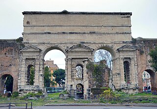
Prima Porta is the 58th zona of Rome, identified by the initials Z. LVIII. The name Prima Porta came from an arch of the aqueduct that brought water to the Villa of Livia, which formed over Via Flaminia a sort of gateway which travellers saw as the first indication of having reached Rome (Piperno).

<span class="mw-page-title-main">Ostia Antica (district)</span> District in Rome

Ostia Antica is the 35th zona of Rome, Italy, four kilometers away from the coast. It is identified by the initials Z. XXXV and it is distinct from Ostia. Ostia Antica belongs to Municipio X.

<span class="mw-page-title-main">Labaro</span> Zona of Rome in Lazio, Italy

Labaro is the 57th zona of Rome, identified by the initials Z. LVII. It is located 11 kilometres north of the city center, along the Via Flaminia, just outside the Grande Raccordo Anulare.

<span class="mw-page-title-main">Cesano (RM)</span> Zona of Rome in Lazio, Italy

Cesano is the 52nd zona of Rome, Italy, identified by the initials Z. LII. It takes its name from the small medieval village of Cesano di Roma, on the Via Cassia, which is located within the Municipio XV, 27 km from Rome proper.

<span class="mw-page-title-main">Settecamini</span> Zona of Rome in Lazio, Italy

Settecamini is the 6th zona of Rome, identified by the initials Z. VI.. Settecamini is also the name of the urban zone 5L, within the Municipio V of Rome.

<span class="mw-page-title-main">Ponte Galeria</span> Zona of Rome in Lazio, Italy

Ponte Galeria is the 41st zona of Rome, Italy, identified by the initials Z. XLI. Geographically it was part of Agro Romano. The zone belongs to the Municipio XI.

<span class="mw-page-title-main">Line C (Rome Metro)</span> Rapid transit line in Rome, Italy

Line C is a Rome Metro line which runs from Monte Compatri-Pantano in the eastern suburbs of Rome, in Italy, to San Giovanni near the city centre, where it meets Line A. It is the third metro line to be built in the city and the first to be fully automated.

<span class="mw-page-title-main">Aqua Alexandrina</span> Roman aqueduct, a landmark of Rome, Italy

The Aqua Alexandrina was a Roman aqueduct located in the city of Rome. The 22.4 km long aqueduct carried water from Pantano Borghese to the Baths of Alexander on the Campus Martius. It remained in use from the 3rd to the 8th century AD.

<span class="mw-page-title-main">Rome–Giardinetti railway</span>

The Roma–Giardinetti railway is a narrow gauge on-street railway which connects Laziali with Giardinetti to the east just past the Grande Raccordo Anulare, Rome's orbital motorway. It is run by ATAC, the company responsible for public transportation in the city, which also operates the Rome Metro.

<span class="mw-page-title-main">Val Melaina</span> Zona of Rome in Lazio, Italy

Val Melaina is the 1st zona of Rome, identified by the initials Z. I, lying north of the city centre and covering an area of 6.2447 km².

<span class="mw-page-title-main">La Storta</span> Zona of Rome in Lazio, Italy

La Storta is the 51st zona of the Italian capital city, Rome. It is identified by the initials Z. LI and falls within the boundaries of Municipio XV.

<span class="mw-page-title-main">Parco di Centocelle (Rome Metro)</span> Rome metro station

Parco di Centocelle is an underground station of Line C of the Rome Metro. It is located near the intersection between the Via Casilina and Via Palmiro Togliatti. It is the last station of Line C following the route of the former Rome–Giardinetti railway. Parco di Centocelle serves as an important interchange between the public transportation corridors of Via Casilina and Via Togliatti.

<span class="mw-page-title-main">Giardinetti (Rome Metro)</span> Rome metro station

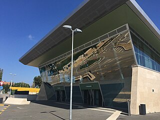
Giardinetti is an underground station of Line C of the Rome Metro. It is located along the Via Casilina, at the intersection with Via degli Orafi and Via della Fattoria di Torrenova, in the Roman district of Giardinetti, near the Grande Raccordo Anulare. Construction of the station started in 2007 and it was opened on 9 November 2014. The homonymous terminus of the Rome–Giardinetti railway line was relocated within 500 metres from the Metro station.

<span class="mw-page-title-main">Torrenova (Rome Metro)</span> Rome metro station

Torrenova is a surface station of Line C of the Rome Metro. It is located in Via Casilina, serving the Roman districts of Torre Angela, Tor Vergata and Giardinetti. It's the only above-ground stop of Line C which retained the original architecture of the historic train station on the Rome–Pantano railway line. The old train station was temporarily closed down in 2008 for restoration and modernisation works; it re-opened on 9 November 2014 as part of the new Metro line.

<span class="mw-page-title-main">Termini-Laziali (Rome–Giardinetti railway)</span> Italian train station

Roma Laziali is a railway station in Rome located next to the southern façade of Termini station. It is the western terminus of the Rome-Giardinetti railway.

<span class="mw-page-title-main">Tor Cervara</span> Zona of Rome in Lazio, Italy

Tor Cervara is the 7th zona of the Italian capital Rome, identified by the initials Z. VII. It belongs to the Municipio IV and has 13,975 inhabitants (2016). It is located in the east of the city, within the Grande Raccordo Anulare, and has an area of 5.9000 km2.

<span class="mw-page-title-main">Municipio VII</span> Municipio of Rome in Lazio, Italy

Municipio Roma VII is the seventh administrative subdivision of the Municipality of Rome (Italy).

<span class="mw-page-title-main">Castel Giubileo</span> Zone of Rome in Lazio, Italy

Castel Giubileo is the second Zone of Rome in the Ager Romanus, identified as Z. II.

<span class="mw-page-title-main">Prenestino-Labicano</span> Quartiere of Rome in Lazio, Italy

Prenestino-Labicano is the 7th quartiere of Rome (Italy), identified by the initials Q. VII. The name derives from the ancient roads Via Prenestina and Via Labicana, today the initial stretch of Via Casilina. It belongs to the Municipio V and Municipio VII.

<span class="mw-page-title-main">Tuscolano</span> Quartiere of Rome in Lazio, Italy

Tuscolano is the 8th quartiere of Rome (Italy), identified by the initials Q. VIII. The name derives from the ancient road Via Tuscolana. It belongs to the Municipio V and Municipio VII.

References

  1. Roma Capitale – Roma Statistica. Population inscribed in the resident register at 31 December 2016 by toponymy subdivision.
  2. See Marina De Franceschini, chapt. 73. Villa di Tor Vergata, loc. Carcaricola, pp. 205-207.
  3. "Scoperto nuovo complesso archeologico a Roma". ADNKronos.

Bibliography

Coordinates: 41°50′55″N12°36′36″E / 41.848721°N 12.609901°E / 41.848721; 12.609901