It was established by the Municipal Assembly, with Resolution nr. 11 of 11 March 2013, following the unification of Municipio Roma IX (formerly Circoscrizione IX) and Municipio Roma X (formerly Circoscrizione X). It is the most populous Municipio in the city, the only one with more than 300,000 inhabitants.
Geography
The territory of the Municipio extends in the south-eastern quadrant of the city, from Porta San Giovanni to the border of the Municipality of Rome, along the road axes of Via Appia Nuova and Via Tuscolana.
The territory of the Municipio was inhabited since prehistoric times, as shown by the excavations of the four necropolises of Osteria del Curato-Via Cinquefrondi, Lucrezia Romana, Romanina and Ponte delle Sette Miglia, with rock-out chamber tombs from the Copper Age, related to the so-called Rinaldone culture.[1][2]
In Roman times, the territory of the Municipio was crossed by the Via Latina and the Via Asinaria. As in the rest of the Ager Romanus – also thanks to several aqueducts that crossed it – there were numerous villae, that is, farming estates of medium extension whose production was at the service of the city.
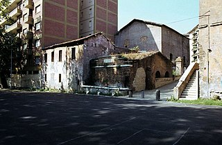
In the Middle Ages the villae were converted into Domuscultae and fortifications and later into farmhouses and towers (such as Tor Fiscale, Torre del Quadraro and Torre di Mezzavia), in close relationship with the settlements towards the Roman Castles. The ancient Roman roads were replaced first by Via Tuscolana and then, in 1574, by Via Appia Nuova, opened by Gregory XIII. In place of the broken aqueducts, in 1122 Callixtus II dug the artificial canal of Acqua Mariana, while in 1587 Sixtus V built the Felice aqueduct, which crosses Via Tuscolana near Porta Furba.
Until the beginning of the 20th century the territory boasted many vineyards and villas – most of which were destroyed due to the subsequent building expansion or, in a few surviving cases, whose area was greatly reduced (the present Villa Lais, Villa Fiorelli and Villa Lazzaroni) – as well as production plants and mills exploiting the water power of Acqua Mariana.[3]
Townhouse near Villa Fiorelli (1995).
The urbanization of the territory began with the master plan of 1909, which declared the areas within the railway to be suitable for small-size buildings and villas, including those that survived around Villa Fiorelli[4]. A tramway line connecting with the Roman castles was also inaugurated in 1903, the Sound stages of Cines film company in 1905 and the Motovelodromo Appio (later demolished) in 1910.
Both the size of the buildings and the population density, however, increased with the 1925 variant and the new 1931 master plan, resulting in an intensive urban fabric in the QuartieriAppio-Latino and Tuscolano, with tall buildings and very few green areas[5]. Meanwhile, in breach of the master plan, various unauthorized settlements arose – such as the Quadraro – as well as "hamlets" made of shacks built against the arches (on Via del Mandrione, at the Caffarella and at the Felice aqueduct, restored and demolished only in the late 1970s).[6]
The year 1937 saw the inauguration of the Cinecittà studios (together with the Istituto Luce and the Centro Sperimentale di Cinematografia), where all the greatest directors and actors of Italian cinema shot movies and which became the "Hollywood on the Tiber" in the years of the Dolce Vita, with many famous American productions (the so-called "colossals").
During the Nazi occupation of Rome in World War II, the inhabitants actively participated in the Resistance, to the point that on 17 April 1944 the German army, as a reprisal, carried out a mop-up in the Quadraro, deporting between 700 and 950 men to Germany. On 17 April 2004 the then Municipio X was awarded the Gold Medal for Civil Valor.[7][8]
After the war, the building expansion continued with the intensive palaces of the QuartieriDon Bosco and Appio Claudio, eventually endangering the Caffarella valley; an exception were the "INA-Casa" buildings between Viale Spartaco and Via Selinunte (on-line, tower and one-family houses with an original urban design, built by the best architects of the "Neorealistic" movement, such as Adalberto Libera). Moving towards the boundaries of the Municipality, there is a prevalence of both extensive buildings, which have been at least partly built illegally (Quarto Miglio, Statuario, Tor Fiscale, Capannelle, Osteria del Curato, Morena, Gregna, Romanina, Vermicino, Passolombardo), as well as modern districts with greater endowments of public green (Cinecittà Est, Torre di Mezzavia, Nuova Romanina, Nuova Tor Vergata).
The new Roman master plan includes the planning of the urban centrality of Anagnina-Romanina.[9]
The urban division of the territory includes the five urban zones of the former Municipio IX and the eleven ones of the former Municipio X. Its population is distributed as follows:[22]
Road mobility in radial direction is ensured by Via Appia Nuova, Via Tuscolana Via Anagnina, as well as the Rome-Naples motorway, which intersect the Grande Raccordo Anulare.
Lazio suburban rail. Line 1: Roma Tuscolana, Line 3: Roma Tuscolana, Line 4: Capannelle, Line 5: Roma Tuscolana, Line 6: Capannelle
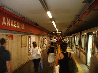
Almost half of the Line A of the Metro runs inside the Municipio, including the large interchange junction of Anagnina, with the terminus of Cotral suburban bus services along Via Tuscolana, Via Casilina, Via Anagnina, Via Appia and Via Nettunense.
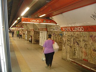
At the Ponte Lungo station it is possible to exchange at the Tuscolana station the FL1, FL3 and FL5 regional railway lines; the other station in the area is that of Capannelle on the FL4 and FL6 lines.
Carver Cinecittà: in the season 2019–2020 plays in the men's Serie C championship.[26]
Cinecittà BK Polaris: in the season 2019–2020 plays in the men's Serie C championship.[26]
Related Research Articles
The Appian Way is one of the earliest and strategically most important Roman roads of the ancient republic. It connected Rome to Brindisi, in southeast Italy. Its importance is indicated by its common name, recorded by Statius, of Appia longarum... regina viarum.
The Aurelian Walls are a line of city walls built between 271 AD and 275 AD in Rome, Italy, during the reign of the Roman Emperor Aurelian. They superseded the earlier Servian Wall built during the 4th century BC.
The city of Rome, Italy is divided into first-level administrative subdivisions.
Esquilino is the 15th rione of Rome, identified by the initials R. XV, and is Located within the Municipio I. It is named after the Esquiline Hill, one of the Seven Hills of Rome.
Torrenova is the 16th zona of Rome, identified by the initials Z. XVI. It belongs partly to the Municipio VI and partly to the Municipio VII.
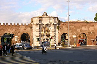
Porta San Giovanni is a gate in the Aurelian Wall of Rome, Italy, named after the nearby Archbasilica of Saint John Lateran.
Via Asinaria was an ancient Roman road that started from Porta Asinaria in the Aurelian walls (Rome). It was somehow connected with the Via Latina, as it is reported that Belisarius, during its advance on Rome, left the Via Latina to enter the city from Porta Asinaria; the latter was considered one of the main accesses for those coming from the south, as in ancient times the 17th-century Porta San Giovanni didn't exist.
Anagnina is a station of Line A of the Rome Metro. It is located at the junction between Via Tuscolana and Via Anagnina, close to the depot of Osteria del Curato. The station rises at 53 metres (174 ft) above sea level.
Furio Camillo is an underground station on Linea A of the Rome Metro. The station was inaugurated in 1980 and is located under Via Appia Nuova, at the junction of Via Cesare Baronio and Viale Furio Camillo, in an area where roads are named after personalities from the earliest history of Rome and characters from the Aeneid.
ATAC S.p.A. is an Italian publicly owned company running most of the local public transportation services, paid parking and incentive parking lots in Rome. More specifically, the company handles, on behalf of Roma Capitale Authority, the entire tramway, trolleybus network and metro lines, as well as most of the bus lines in the city. It also operates, on behalf of the Administrative Region of Lazio, three railways: Roma-Civita Castellana-Viterbo, Roma-Giardinetti and Roma-Lido. ATAC S.p.A., with its 2,200-kilometer-wide public transport network, its over 8,500 busses and 70,000 parking stalls, is currently one of the biggest public transportation companies in Europe and the largest in Italy.
The Villa dei Sette Bassi is an archaeological site located in Rome, Italy.
The Appian Way Regional Park is the second-largest urban park of Europe, after Losiny Ostrov National Park in Moscow. It is a protected area of around 4580 hectares, established by the Italian region of Latium. It falls primarily within the territory of Rome but parts also extend into the neighbouring towns of Ciampino and Marino.
Ponte Lungo is a station on the Rome Metro. It is on Line A and is located in Appio Latino, between Re di Roma and Furio Camillo stations.
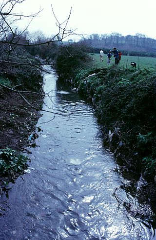
The Almone is a small river of the Ager Romanus, a few miles south of the city of Rome. Today the river is polluted and is channelled to a sewage treatment plant and no longer reaches its natural confluence with the Tiber.
The following outline is provided as an overview of and topical guide to Rome:
Tuscolano is the 8th quartiere of Rome (Italy), identified by the initials Q. VIII. The name derives from the ancient road Via Tuscolana. It belongs to the Municipio V and Municipio VII.
Appio-Latino is the 9th quartiere of Rome (Italy), identified by the initials Q. IX. The name derives from the ancient roads Via Appia and Via Latina. It belongs to the Municipio VII and Municipio VIII.
Via dei Cessati Spiriti is a street in Rome (Italy), established as a result of an adjustment of the route of Via Appia Nuova, which took place in the 1940s.
Ardeatino is the 20th quartiere of Rome (Italy), identified by the initials Q. XX. It belongs to the Municipio I and VIII.
↑ Anna Paola Anzidei; Giovanni Carboni (2020). Roma prima del mito. Abitati e necropoli dal neolitico alla prima età dei metalli nel territorio di Roma (VI-III millennio a.C.). Archaeopress. pp.435–658.
This page is based on this Wikipedia article Text is available under the CC BY-SA 4.0 license; additional terms may apply. Images, videos and audio are available under their respective licenses.