Administrative subdivisions of Rome

Last updated

Municipi of Rome
Roma municipi locator map with numbers.svg
The fifteen Rome municipi
CategoryLocal government districts
Location Rome
Created
  • 19 January 2001
Number15 (as of 2013)
Populations130,000–300,000
Areas20–180 km2
Government
  • President and
    Municipal Council(s)

The city of Rome, Italy, is divided into first-level administrative subdivisions.

Contents

There are 15 municipi (SG: municipio) in the city; each municipio is governed by a president and a council who are elected directly by its residents every five years. The municipi collectively comprise the comune of Rome, which is itself one of the constituent parts of the wider Metropolitan City of Rome Capital.

History

On 31 March 1966, for administrative purposes and to increase decentralization, the territory of the comune of Rome was divided into 12 administrative areas, called circoscrizioni (singular: circoscrizione). On 11 February 1972 those areas were increased to 20.

On 6 March 1992, after the referendum that ratified the separation of the then Circoscrizione XIV from Rome and the birth of the new independent comune of Fiumicino, the number of administrative areas of Rome decreased to 19.

On 19 January 2001, circoscrizioni which were renamed municipi and the direct election of a President to head each municipio was established. [1]

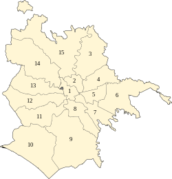
On 11 March 2013, Rome City Council decided to merge some of the municipi, reducing their number to 15 and giving them a new numeration. [2]

Municipi

MunicipioPopulation
31 December 2015
Area
in km2
Density
per km2
Map
Municipio I – Historical Center186,80219.919,382 Roma municipi locator map with numbers.svg
Municipio IIParioli/Nomentano167,73619.608,567
Municipio III – Monte Sacro204,51497.822,091
Municipio IV – Tiburtina177,08449.153,603
Municipio V – Prenestino/Centocelle246,47127.009,137
Municipio VI – Roma Delle Torri256,261113.402,261
Municipio VII – Appio-Latino/Tuscolano/Cinecittà 307,60746.806,580
Municipio VIII – Appia Antica131,08247.292,772
Municipio IXEUR 180,511183.17985
Municipio XOstia/Acilia230,544150.641,530
Municipio XI – Arvalia/Portuense154,87170.902,185
Municipio XII – Monte Verde140,99673.121,928
Municipio XIII – Aurelia133,81368.701,949
Municipio XIVMonte Mario 190,513131.301,451
Municipio XV – Cassia/Flaminia158,561186.70849

Presidents of the municipi

For the current legislature (2021–2026), presidents of Rome's municipi are:

N.PresidentPartyMayoral
majority
ILorenza Bonaccorsi PD Yes check.svg
IIFrancesca Del Bello PD Yes check.svg
IIIPaolo Emilio Marchionne PD Yes check.svg
IVMassimiliano Uberti PD Yes check.svg
VMauro Caliste PD Yes check.svg
VINicola Franco Fdl
VIIFrancesco Laddaga PD Yes check.svg
VIIIAmedeo Ciaccheri SI Yes check.svg
IXTitti Di Salvo PD Yes check.svg
XMario Falconi PD Yes check.svg
XIGianluca Lanzi PD Yes check.svg
XIIElia Tomassetti PD Yes check.svg
XIIISabrina Giuseppetti PD Yes check.svg
XIVMarco Della Porta PD Yes check.svg
XVDaniele Torquati PD Yes check.svg

Urban subdivision of Rome

The comune of Rome is also composed of 155 urban zones (zone urbanistiche), conceived as a subdivision of the municipi, which were established in 1977 for statistical and city planning purposes on the basis of urban homogeneity criteria. Boundaries were drafted taking account of the discontinuities in Rome's urban pattern The urban zones are identified by an alphanumeric code that consists of a letter and of the number of the municipio where the zone was located: indeed, the municipi were reduced from 20 to 15 in 2013, but the alphanumeric codes were not revised.

Historical subdivisions of Rome

Map of the subdivisions of Rome:
.mw-parser-output .legend{page-break-inside:avoid;break-inside:avoid-column}.mw-parser-output .legend-color{display:inline-block;min-width:1.25em;height:1.25em;line-height:1.25;margin:1px 0;text-align:center;border:1px solid black;background-color:transparent;color:black}.mw-parser-output .legend-text{}
rioni ("districts")
quartieri ("neighborhoods")
suburbi ("suburbs")
zone dell'agro romano ("areas of Agro romano") Rome subdivisions by color.svg
Map of the subdivisions of Rome:
  rioni ("districts")
  quartieri ("neighborhoods")
  suburbi ("suburbs")
  zone dell'agro romano ("areas of Agro romano")

Rome is also divided into 116 non-administrative units, called comprensori toponomastici (toponymic districts), which are organized into four groups:

List of historic Rioni in Rome's centre

The rioni originate from the Regiones of ancient Rome, which evolved in the Middle Ages into the medieval rioni. [3] In the Renaissance, under Pope Sixtus V, they reached again the number of fourteen, and their boundaries were finally defined under Pope Benedict XIV in 1743.

A new subdivision of the city under Napoleon was ephemeral, and there were no sensible changes in the organisation of the city until 1870 when Rome became the capital of Italy. The needs of the new capital led to an explosion both in the urbanisation and in the population within and outside the Aurelian Walls. In 1874 a fifteenth rione, Esquilino, was created on the newly urbanised zone of Monti. At the beginning of the 20th century other rioni where created (the last one was Prati – the only one outside the Walls of Pope Urban VIII – in 1921). Afterward, for the new administrative subdivisions of the city the name "quartiere" was used. Today all the rioni are part of the first Municipio, which therefore coincides completely with the historical city (Centro Storico).[ citation needed ]

A map of Rome's historic center with its rioni Rioni of Rome locator map with Roman numbers.svg
A map of Rome's historic center with its rioni
RioneNamePopulation
(2016)
R. I Monti 13,028
R. II Trevi 2,327
R. III Colonna 2,111
R. IV Campo Marzio 5,860
R. V Ponte 3,596
R. VI Parione 2,572
R. VII Regola 3,328
R. VIII Sant'Eustachio 1,962
R. IX Pigna 10,737
R. X Campitelli 552
R. XI Sant'Angelo 1,084
R. XII Ripa 2,520
R. XIII Trastevere 19,229
R. XIV Borgo 2,954
R. XV Esquilino 24,167
R. XVI Ludovisi 1,612
R. XVII Sallustiano 2,225
R. XVIII Castro Pretorio 5,341
R. XIX Celio 2,519
R. XX Testaccio 8,088
R. XXI San Saba 3,531
R. XXII Prati 15,270
RioniTotal186,802

List of Rome's quartieri

Quarters of Rome Quartieri di Roma locator map with Roman numbers.svg
Quarters of Rome

List of Rome's suburbi

There are currently 6 suburbi with a discontinuous numbering, since some of the original suburbs were established as quartieri in 1961, following to the urban development of the city.

Related Research Articles

<span class="mw-page-title-main">Trastevere</span> Rione of Rome in Lazio, Italy

Trastevere is the 13th rione of Rome: it is identified by the initials R. XIII and it is located within Municipio I. Its name comes from Latin trans Tiberim, literally 'beyond the Tiber'.

<span class="mw-page-title-main">Rioni of Rome</span> Traditional administrative division of the city of Rome

A rione of Rome is a traditional administrative division of the city of Rome. Rione is an Italian term used since the 14th century to name a district of a town. The term was born in Rome, originating from the administrative divisions of the city. The word comes from the Latin word regio ; during the Middle Ages the Latin word became rejones, from which rione comes. Currently, all the rioni are located in Municipio I of Rome.

<span class="mw-page-title-main">Prati</span> Rione of Rome in Lazio, Italy

Prati is the 22nd rione of Rome, identified by the initials R. XXII. It belongs to the Municipio I since 2013, while previously, along with Borgo and quartieri Trionfale and Della Vittoria, it was part of the Municipio XVII.

<span class="mw-page-title-main">Municipio XIX</span> Place in Rome, Italy

The Municipio XIX was an administrative subdivision of the city of Rome. Following the administrative reform of 11 March 2013, it was suppressed and merged into the new, and coextensive, Municipio XIV. Its territory is situated to the north-west part of the municipality of Rome.

<span class="mw-page-title-main">Municipio I</span> Municipio of Rome in Lazio, Italy

Municipio I is an administrative subdivision of the municipality of Rome, encompassing the centre of the city.

<span class="mw-page-title-main">Portuense</span> Quartiere of Rome in Lazio, Italy

<span class="mw-page-title-main">Pietralata (Rome)</span> Quartiere of Rome in Lazio, Italy

Pietralata is the 21st quartiere of Rome, identified by the initials Q. XXI, and belongs to the Municipio IV. Its name comes from the Latin Prata Lata meaning large fields, which is possibly a reference to the large amount of nature and vegetation present.

<span class="mw-page-title-main">Municipio III</span> Municipio of Rome in Lazio, Italy

Municipio Roma III is the third administrative subdivision of Rome (Italy).

<span class="mw-page-title-main">Outline of Rome</span> Overview of and topical guide to Rome

The following outline is provided as an overview of and topical guide to Rome:

<span class="mw-page-title-main">Quarters of Rome</span>

The Quarters of Rome are the areas in and around the Italian city of Rome which became urbanised after the foundation of the last city-centre rione, Prati.

<span class="mw-page-title-main">Municipio VII</span> Municipio of Rome in Lazio, Italy

Municipio Roma VII is the seventh administrative subdivision of the Municipality of Rome (Italy).

<span class="mw-page-title-main">Municipio IX</span> Municipio of Rome in Lazio, Italy

Municipio Roma IX is the ninth administrative subdivision of Rome (Italy).

<span class="mw-page-title-main">Zones of Rome</span> Subdivisions of the Rome metropolitan area

The zones of Rome are toponymic subdivisions within the area of the Ager Romanus, belonging to the Municipalities of Rome and Fiumicino, Italy.

<span class="mw-page-title-main">Suburbs of Rome</span>

The Suburbi di Roma are the third level of toponomastic subdivision of the Municipality of Rome (Italy).

<span class="mw-page-title-main">Prenestino-Labicano</span> Quartiere of Rome in Lazio, Italy

Prenestino-Labicano is the 7th quartiere of Rome (Italy), identified by the initials Q. VII. The name derives from the ancient roads Via Prenestina and Via Labicana, today the initial stretch of Via Casilina. It belongs to the Municipio V and Municipio VII.

<span class="mw-page-title-main">Tuscolano</span> Quartiere of Rome in Lazio, Italy

Tuscolano is the 8th quartiere of Rome (Italy), identified by the initials Q. VIII. The name derives from the ancient road Via Tuscolana. It belongs to the Municipio V and Municipio VII.

<span class="mw-page-title-main">Gianicolense</span> Quartiere of Rome in Lazio, Italy

Gianicolense is the 12th quartiere of Rome (Italy), identified by the initials Q. XII. It belongs to the Municipio XI and Municipio XII. It takes its name from the Janiculum hill, which lies in the nearby rione Trastevere and whose western extremities correspond to the area of Monteverde.

<span class="mw-page-title-main">Aurelio (Rome)</span> Quartiere of Rome in Lazio, Italy

Aurelio is the 13th quartiere of Rome (Italy), identified by the initials Q. XIII. It belongs to the Municipio XIII and Municipio XIV.

<span class="mw-page-title-main">Trionfale</span> Quartiere of Rome in Lazio, Italy

Trionfale is the 14th quartiere of Rome (Italy), identified by the initials Q. XIV. The toponym also indicates the urban zone 19E of Municipio XIV.

<span class="mw-page-title-main">Ardeatino</span> District in Rome, Italy

Ardeatino is the 20th quartiere of Rome, identified by the initials "Q. XX". It belongs to the Municipio I and VIII.

References

  1. "Strutture territoriali" (in Italian). Comune di Roma. Retrieved 20 December 2013.
  2. "Roma, sì all'accorpamento dei municipi: il Consiglio li riduce da 19 a 15". Il Messaggero. 11 March 2013. Archived from the original on 16 March 2013. Retrieved 13 March 2013.
  3. "The "Rioni" of Rome". Romeartlover.it. Retrieved 3 February 2010.

Commons-logo.svg Media related to Subdivisions of Rome at Wikimedia Commons