La Storta | |
---|---|
Zona of Rome | |
Country | Italy |
Region | Lazio |
Province | Rome |
Comune | Rome |
Area | |
• Total | 18.0198 sq mi (46.6710 km2) |
Population (2016) [1] | |
• Total | 21,283 |
• Density | 1,181.1/sq mi (456.02/km2) |
Time zone | UTC+1 (CET) |
• Summer (DST) | UTC+2 (CEST) |
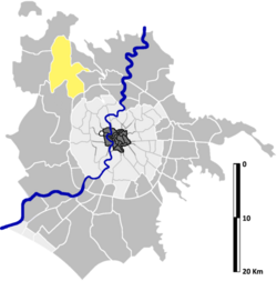
La Storta is the 51st zona of the Italian capital city, Rome. It is identified by the initials Z. LI and falls within the boundaries of Municipio XV. [note 1]
The name La Storta ("the curve"; literally 'twisted' or 'bent') refers to a series of curves that the Via Cassia makes through the settlement. [3]
During the Middle Ages the locality was positioned along the Via Francigena, and was specifically mentioned as being a stop on the itinerary of Sigeric the Serious during his journey to Rome to accept the pallium as archbishop of Canterbury. [4] The surviving account of his journey refers to La Storta as [Submansio] Joannis VIIII, the first stop outside of the city of Rome. [note 2] The stop was also referred to as San Giovanni in Nono (Latin : Sanctus Ioannes in Nono), since the way station was constructed next to a church dedicated to Saint John, and positioned at the nine-mile marker from the start of the Via Cassia. [5]
In November 1537, Ignatius of Loyola was traveling the Via Cassia towards Rome, accompanied by Peter Faber and Diego Laynez. The group paused at a small church in La Storta to pray. [6] It was there that Ignatius is reported to have received a vision of God the Father and Christ holding the cross. Ignatius would later report that the Father had "given him ... to be henceforward consecrated wholly to His service," and Christ spoke the words Ego tibi Romae propitius ero ("I will be favorable to you in Rome"). [6] [7] The meaning of the sentence was not immediately clear to Ignatius, who thought it could mean that the three might be martyred at Rome. [6] Pope Paul III instead gave him a very friendly reception. [6]
The location of the apparition is memorialized today with a small chapel dedicated to Saint Ignatius in the Piazza della Visione ("Square of the Vision"). [8] The site of the vision was a place of pilgrimage from the early days of the Society of Jesus, but the current form of the chapel was achieved only in the year 1700, when it was restored and decorated by the Superior General Thyrsus González de Santalla. [8] The community celebrates the vision with its own feast day, the Feast of the Vision of Saint Ignatius. [9] (The feast day is not, however, an ancient tradition, having been celebrated for the first time in 2011.) The feast is celebrated on the second Sunday of November, and is marked by processions, bands, and a reenactment of the vision. [9]
On June 4, 1944, the Nazis, who were fleeing from Rome after its liberation, carried out the massacre of fourteen prisoners in the community. Twelve of the fourteen were Italians, including the trade unionist Bruno Buozzi; the other two were a Polish Jew and the Englishman John Armstrong. [2] The German soldiers were moving out in a column of vehicles during the night of June 3 to June 4, attempting to escape the Allied advance on the city, and executed the prisoners on the grounds of the Grazioli estate in the country, a forested area 14 km (8.7 mi) down the Via Cassia from La Storta. [2] It is not known who issued the order. [2]
La Storta is the seat of the bishop of the Suburbicarian Diocese of Porto-Santa Rufina, [10] the territory of which stretches from the GRA to the Tyrrhenian Sea. [11]
The Cathedral of the Sacred Hearts of Jesus and Mary (Italian : Cattedrale dei Sacri Cuori di Gesù e Maria) is located in La Storta. The construction of the present-day cathedral building was abandoned in 1926, having been a project of a German Jesuit, Father Leopoldo Fonck, who intended the church to be dedicated to Saint Margaret Mary Alacoque. [12] Construction was suspended, however, and the building was not completed until Cardinal Tisserant took a personal interest and raised funds from sources including the United States. [12] The new cathedral was dedicated on March 25, 1950, hosted a diocesan synod in August 1957, and was visited by Pope Pius XII on October 27 of the same year. [12] In 1990, construction of a diocesan curia building was completed nearby. [12]
The territory of La Storta includes the urban zone 20HLa Storta and part of the urban zone 19GCastelluccia.
It also includes the locality of Pian Saccoccia (piano di zona B49): here is located an unauthorized settlement for which the municipality approved a restoration plan.
The zone borders, to the north, with Zona Cesano (Z. LII), from which is separated by the Rio Galeria and by Via di Baccanello, up to Via Cassia.
Eastward, it borders with Zona Isola Farnese (Z. LV), whose border is marked by the stretch of Via Cassia between Via di Baccanello and Via Isola Farnese, by Via Isola Farnese itself, by the countryside up to Via Prato della Corte and by Via Prato della Corte up to the Cremera, the by the stream itself To the east, La Storta also borders with Zona La Giustiniana (Z. LIV), whose border is outlined by the Cremera, by Via Anna Foà, by the countryside up to Via Giacomo Andreassi, then by Via Cassia and Via Trionfale, up to the GRA.
To the south, the zone borders with Zona Ottavia (Z. L), from which is separated by the stretch of the GRA between Via Trionfale and Via Cogliate. Southward, La Storta also borders with Zona Casalotti (Z. XLVIII), whose border is outlined by the countryside between Via Cogliate and Via della Storta, by a stretch of Via della Storta itself, then by the countryside up to the Rio Galeria and by the stream itself.
Westward, La Storta borders with Zona Santa Maria di Galeria (Z. XLIX), from which is separated by the Rio Galeria, up to Via Braccianese.
For the most part, odonyms of La Storta refers to Italian playwrights and theatre directors. In the southern part of the zone, some streets are named after cardinals, saints and religious benefactors. Streets in the locality of Pian Saccoccia are mainly named after prominent publishers. Odonyms of the zone can be categorized as follows:
The settlement is home to St. George's British International School, founded in 1958. [13]
Prati is the 22nd rione of Rome, Italy, identified by the initials R. XXII. It belongs to the Municipio I since 2013, while previously, along with Borgo and quartieri Trionfale and Della Vittoria, it was part of the Municipio XVII.
Campo Marzio is the 4th rione of Rome, Italy, identified by the initials R. IV. It belongs to the Municipio I and covers a smaller section of the area of the ancient Campus Martius. The logo of this rione is a silver crescent on a blue background.
Prima Porta is the 58th zona of Rome, identified by the initials Z. LVIII. The name Prima Porta came from an arch of the aqueduct that brought water to the Villa of Livia, which formed over Via Flaminia a sort of gateway which travellers saw as the first indication of having reached Rome (Piperno).
Ostia Antica is the 35th zona of Rome, Italy, four kilometers away from the coast. It is identified by the initials Z. XXXV and it is distinct from Ostia. Ostia Antica belongs to Municipio X.
Torrenova is the 16th zona of Rome, identified by the initials Z. XVI. It belongs partly to the Municipio VI and partly to the Municipio VII.
Labaro is the 57th zona of Rome, identified by the initials Z. LVII. It is located 11 kilometres north of the city center, along the Via Flaminia, just outside the Grande Raccordo Anulare.
The Diocese of Porto–Santa Rufina is a Latin suburbicarian diocese of the Diocese of Rome and a diocese of the Catholic Church in Italy. It was formed from the union of two dioceses. The diocese of Santa Rufina was also formerly known as Silva Candida.
Cesano is the 52nd zona of Rome, Italy, identified by the initials Z. LII. It takes its name from the small medieval village of Cesano di Roma, on the Via Cassia, which is located within the Municipio XV, 27 km from Rome proper.
Settecamini is the 6th zona of Rome, identified by the initials Z. VI.. Settecamini is also the name of the urban zone 5L, within the Municipio V of Rome.
Ponte Galeria is the 41st zona of Rome, Italy, identified by the initials Z. XLI. Geographically it was part of Agro Romano. The zone belongs to the Municipio XI.
Balduina is an urban area that belongs to the Municipio XIX of the comune of Rome, Italy, and to the fourteenth borough of the city,. Situated at 139 metres above sea level on the southern side of Monte Mario, Balduina is the highest part of Rome. The population is 42,000.
Val Melaina is the 1st zona of Rome, identified by the initials Z. I, lying north of the city centre and covering an area of 6.2447 km².
Giuliano-Dalmata is the 31st quartiere of Rome, identified by the initials Q. XXXI. Its name refers to the Julian, Istrian and Dalmatian refugees that settled there in the postwar period.
Pietralata is the 21st quartiere of Rome, identified by the initials Q. XXI, and belongs to the Municipio IV. Its name comes from the Latin Prata Lata meaning large fields, which is possibly a reference to the large amount of nature and vegetation present.
Massimina is the urban zone 16E of Municipio XII of Rome. In a separate subdivision scheme, it belongs to zone "O" 20 A-B. Massimina is included in zone XLV Castel di Guido.
Tor Cervara is the 7th zona of the Italian capital Rome, identified by the initials Z. VII. It belongs to the Municipio IV and has 13,975 inhabitants (2016). It is located in the east of the city, within the Grande Raccordo Anulare, and has an area of 5.9000 km2.
Polline Martignano is the 59th zona of the Italian capital Rome, abbreviated as Z. LIX. It belongs to the Municipio XV and has 40 inhabitants (2016). It is located as an exclave in the northwest of the city and it is surrounded by the municipalities of Anguillara Sabazia, Campagnano di Roma and Trevignano Romano.
Castel Giubileo is the second Zone of Rome in the Ager Romanus, identified as Z. II.
Tuscolano is the 8th quartiere of Rome (Italy), identified by the initials Q. VIII. The name derives from the ancient road Via Tuscolana. It belongs to the Municipio V and Municipio VII.
Appio-Latino is the 9th quartiere of Rome (Italy), identified by the initials Q. IX. The name derives from the ancient roads Via Appia and Via Latina. It belongs to the Municipio VII and Municipio VIII.