The history of the current Castel Giubileo dates back directly to the ancient city of Fidenae which, based on archaeological evidence, was built around the 11th century BC in an extremely important strategic position between Via Salaria and Via Nomentana. From here, it dominated the commercial routes between Etruria, Sabina and southern Italy, as well as the navigable stretch of the Tiber, where the commercial traffic took place. The settlement, surrounded by walls, extended its control also to the area of Monte Sacro and was flourishing – above all in consideration of the fertility of the soil (due to the proximity to the river and the presence of volcanic debris or Tuffs) – even before the foundation of Rome.
In 1280 the area belonged to the monastery of St. Cyriacus. Later, the castle (castrum) was purchased by Pope Boniface VIII, maybe with the proceeds from the 1300 Jubilee; hence the origin of the name Castel Giubileo is commonly assumed. Actually the name derives from that of the Giubilei family from the rione Trevi, to which a certain Buzio di Giubileo belonged still in 1371.[2]
Due to the strategic importance of its location, the condottiero Paolo Orsini attacked and occupied it in 1406. Stories of looting and depredations continued in the following periods, thus decreeding the complete abandonment of the Castle until the end of the 19th century, when it began to be used for agricultural purposes.
The present urban settlement was built after World War II by immigrants coming from many Italian regions, including the first Venetian farmhands, called by Mussolini for the reclamation of the Ager Romanus.
The Castel Giubileo train wreck
A photo of the trains after the collision.
On 12 August 1900, at. 11:51pm, the area was the scene of a serious train wreck, which occurred along the Florence-Rome railway. A failure to report a train, which had stopped due to a breakdown, caused a rear-end collision with twenty victims and a hundred injured. The disaster had great resonance at the time, as the crashed train was transporting the foreign delegations who had just attended the funeral of King Umberto I and the subsequent coronation of Victor Emmanuel III.
Among the victims was the Baron Giuseppe Baratelli, Senator of the Kingdom, to whom Alfredo Oriani dedicated his book Ombre di occaso.[3] Among the other passengers involved in the wreck there was the Duke of Oporto, the Turkish delegation and the representative of the King of Belgium, who suffered the fracture of both legs.[4]
Geography
The zone is located in the northern area of the city, close to and inside the Grande Raccordo Anulare. The territory of Castel Giubileo includes the urban zones4DFidene, 4ESerpentara and part of the urban zone 4LAeroporto dell'Urbe.
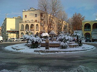
The historical village of Castel Giubileo, wedged between the Via Salaria and the river Tiber, is made up of three small, distinct cores, one of which is located on the low hill where the homonymous castle rises. The two cores at the foot of the hill converge in a larger one in the north, structured according to a sequence of parallel streets between two main roads (Via Grottazzolina and Via Montappone) which can be regarded as the main axes of the settlement. At the western end of this area there are small artisan businesses and some hotels. The commercial area (very modest in size) extends along the axis in the south. Another housing complex is located close to the bank of the Tiber: here there is a primary school and a nursery.
The shopping center Galleria Porta di Roma, surrounded by Via Casale Redicicoli, on the border with Casal Boccone, was inaugurated in 2007.
Boundaries
Castel Giubileo borders northward with ZonaMarcigliana (Z.III), whose boundary is marked by a stretch of the Grande Raccordo Anulare, between Ponte di Castel Giubileo and Via di Settebagni.
Eastward, the zone borders with ZonaCasal Boccone (Z. IV), from which is separated by Via di Settebagni (near the Grande Raccordo Anulare), Viale Franco Arcalli, Piazza Giulietta Masina, Via Elsa de' Giorgi, Via Giuseppe De Santis and Via delle Vigne Nuove up to the Viadotto Antonio Segni.
To the west, Castel Giubileo borders with ZonaGrottarossa (Z. LVI), from which is separated by the Tiber, up to the Ponte di Castel Giubileo (Grande Raccordo Anulare).
In addition to the odonyms of the area of Fidene (municipalities of Tuscany), Colle Salario (municipalities of Marche), streets and squares are mainly dedicated to actors and directors (particularly in the area of Serpentara) and to opera singers. In the frazione of Villa Spada, there is a group of streets named after religious personalities. Odonyms of the zone can be categorized as follows:
Between 1906 and 1932 the locality was also served by a stop of the Rome-Civita Castellana tramway, managed by Società Romana per le Ferrovie del Nord (SRFN).
Trastevere is the 13th rione of Rome: it is identified by the initials R. XIII and it is located within Municipio I. Its name comes from Latin trans Tiberim, literally 'beyond the Tiber'.
Regola is the 7th rione of Rome, Italy, identified by the initials R. VII, and belongs to the Municipio I. The name comes from Arenula, which was the name of the soft sand that the river Tiber left after the floods, and that built strands on the left bank.
Parioli is the 2nd quartiere of Rome, identified by the initials Q. II.
Prima Porta is the 58th zona of Rome, identified by the initials Z. LVIII. The name Prima Porta came from an arch of the aqueduct that brought water to the Villa of Livia, which formed over Via Flaminia a sort of gateway which travellers saw as the first indication of having reached Rome (Piperno).
Torrenova is the 16th zona of Rome, identified by the initials Z. XVI. It belongs partly to the Municipio VI and partly to the Municipio VII.
Labaro is the 57th zona of Rome, identified by the initials Z. LVII. It is located 11 kilometres north of the city center, along the Via Flaminia, just outside the Grande Raccordo Anulare.
Primavalle is the 27th quartiere of Rome, identified by the initials Q. XXVII. It is part of the Municipio XIV.
Settecamini is the 6th zona of Rome, identified by the initials Z. VI.. Settecamini is also the name of the urban zone 5L, within the Municipio V of Rome.
Ponte Galeria is the 41st zona of Rome, Italy, identified by the initials Z. XLI. Geographically it was part of Agro Romano. The zone belongs to the Municipio XI.
Via Cristoforo Colombo is a street in Rome (Italy) that links the historic centre to Ostia. Along most of its route, the street has three lanes for each direction of movement. With its 27 kilometres (17 mi) length it is the longest Italian road among those included within the borders of a single municipality and, in several stretches, the largest in Italy.
Colle Salario is a frazione of the Municipality of Rome (Italy), located in the zone Z. II Castel Giubileo, within the territory of the urban zone 4E Serpentara of the Municipio Roma III.
Val Melaina is the 1st zona of Rome, identified by the initials Z. I, lying north of the city centre and covering an area of 6.2447 km ².
Giuliano-Dalmata is the 31st quartiere of Rome, identified by the initials Q. XXXI. Its name refers to the Julian, Istrian and Dalmatian refugees that settled there in the postwar period.
Massimina is the urban zone 16E of Municipio XII of Rome. In a separate subdivision scheme, it belongs to zone "O" 20 A-B. Massimina is included in zone XLV Castel di Guido.
Municipio Roma III is the third administrative subdivision of Rome (Italy).
Tor Cervara is the 7th zona of the Italian capital Rome, identified by the initials Z. VII. It belongs to the Municipio IV and has 13,975 inhabitants (2016). It is located in the east of the city, within the Grande Raccordo Anulare, and has an area of 5.9000 km2.
Tiburtino is the 6th quartiere of Rome (Italy), identified by the initials Q. VI. The name derives from the ancient road Via Tiburtina. It belongs to the Municipio II, Municipio IV and Municipio V.
Prenestino-Labicano is the 7th quartiere of Rome (Italy), identified by the initials Q. VII. The name derives from the ancient roads Via Prenestina and Via Labicana, today the initial stretch of Via Casilina. It belongs to the Municipio V and Municipio VII.
Tuscolano is the 8th quartiere of Rome (Italy), identified by the initials Q. VIII. The name derives from the ancient road Via Tuscolana. It belongs to the Municipio V and Municipio VII.
Gianicolense[dʒanikoˈlɛnse] is the 12th quartiere of Rome (Italy), identified by the initials Q. XII. It belongs to the Municipio XI and Municipio XII. It takes its name from the Janiculum hill, which lies in the nearby rione Trastevere and whose western extremities correspond to the area of Monteverde.
This page is based on this Wikipedia article Text is available under the CC BY-SA 4.0 license; additional terms may apply. Images, videos and audio are available under their respective licenses.