The Laboratory for Atmospheric and Space Physics (LASP) is a research organization at the University of Colorado Boulder. LASP is a research institute with over one hundred research scientists ranging in fields from solar influences, to Earth's and other planetary atmospherics processes, space weather, space plasma and dusty plasma physics. LASP has advanced technical capabilities specializing in designing, building, and operating spacecraft and spacecraft instruments.

The Nimbus satellites were second-generation U.S. robotic spacecraft launched between 1964 and 1978 used for meteorological research and development. The spacecraft were designed to serve as stabilized, Earth-oriented platforms for the testing of advanced systems to sense and collect atmospheric science data. Seven Nimbus spacecraft have been launched into near-polar, Sun-synchronous orbits beginning with Nimbus 1 on August 28, 1964. On board the Nimbus satellites are various instrumentation for imaging, sounding, and other studies in different spectral regions. The Nimbus satellites were launched aboard Thor-Agena rockets and Delta rockets.

Mars 96 was a failed Mars mission launched in 1996 to investigate Mars by the Russian Space Forces and not directly related to the Soviet Mars probe program of the same name. After failure of the second fourth-stage burn, the probe assembly re-entered the Earth's atmosphere, breaking up over a 320 km (200 mi) long portion of the Pacific Ocean, Chile, and Bolivia. The Mars 96 spacecraft was based on the Phobos probes launched to Mars in 1988. They were of a new design at the time and both ultimately failed. For the Mars 96 mission the designers believed they had corrected the flaws of the Phobos probes, but the value of their improvements was never demonstrated due to the destruction of the probe during the launch phase.
The Earth Observing System (EOS) is a program of NASA comprising a series of artificial satellite missions and scientific instruments in Earth orbit designed for long-term global observations of the land surface, biosphere, atmosphere, and oceans. Since the early 1970s, NASA has been developing its Earth Observing System, launching a series of Landsat satellites in the decade. Some of the first included passive microwave imaging in 1972 through the Nimbus 5 satellite. Following the launch of various satellite missions, the conception of the program began in the late 1980s and expanded rapidly through the 1990s. Since the inception of the program, it has continued to develop, including; land, sea, radiation and atmosphere. Collected in a system known as EOSDIS, NASA uses this data in order to study the progression and changes in the biosphere of Earth. The main focus of this data collection surrounds climatic science. The program is the centrepiece of NASA's Earth Science Enterprise.
SCISAT-1 is a Canadian satellite designed to make observations of the Earth's atmosphere. Its main instruments are an optical Fourier transform infrared spectrometer, the ACE-FTS Instrument, and an ultraviolet spectrophotometer, MAESTRO. These devices record spectra of the Sun, as sunlight passes through the Earth's atmosphere, making analyses of the chemical elements of the atmosphere possible.

The Meteor spacecraft are weather observation satellites launched by the Soviet Union and Russia. The Meteor satellite series was initially developed during the 1960s. The Meteor satellites were designed to monitor atmospheric and sea-surface temperatures, humidity, radiation, sea ice conditions, snow-cover, and clouds. Between 1964 and 1969, a total of eleven Soviet Union Meteor satellites were launched.

The NASA QuikSCAT was an Earth observation satellite carrying the SeaWinds scatterometer. Its primary mission was to measure the surface wind speed and direction over the ice-free global oceans via its effect on water waves. Observations from QuikSCAT had a wide array of applications, and contributed to climatological studies, weather forecasting, meteorology, oceanographic research, marine safety, commercial fishing, tracking large icebergs, and studies of land and sea ice, among others. This SeaWinds scatterometer is referred to as the QuikSCAT scatterometer to distinguish it from the nearly identical SeaWinds scatterometer flown on the ADEOS-2 satellite.
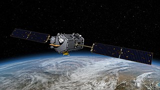
The Orbiting Carbon Observatory (OCO) was a failed NASA satellite mission intended to provide global space-based observations of atmospheric carbon dioxide. The original spacecraft was lost in a launch failure on 24 February 2009, when the payload fairing of the Taurus rocket which was carrying it failed to separate during ascent. The added mass of the fairing prevented the satellite from reaching orbit. It subsequently re-entered the atmosphere and crashed into the Indian Ocean near Antarctica. The replacement satellite, Orbiting Carbon Observatory-2, was launched 2 July 2014 aboard a Delta II rocket. The Orbiting Carbon Observatory-3, a stand-alone payload built from the spare OCO-2 flight instrument, was installed on the International Space Station's Kibō Exposed Facility in May 2019.

The Earth Radiation Budget Satellite (ERBS) was a NASA scientific research satellite. The satellite was one of three satellites in NASA's research program, named Earth Radiation Budget Experiment (ERBE), to investigate the Earth's radiation budget. The satellite also carried an instrument that studied stratospheric aerosol and gases.

Over the last two centuries many environmental chemical observations have been made from a variety of ground-based, airborne, and orbital platforms and deposited in databases. Many of these databases are publicly available. All of the instruments mentioned in this article give online public access to their data. These observations are critical in developing our understanding of the Earth's atmosphere and issues such as climate change, ozone depletion and air quality. Some of the external links provide repositories of many of these datasets in one place. For example, the Cambridge Atmospheric Chemical Database, is a large database in a uniform ASCII format. Each observation is augmented with the meteorological conditions such as the temperature, potential temperature, geopotential height, and equivalent PV latitude.

The ozone monitoring instrument (OMI) is a nadir-viewing visual and ultraviolet spectrometer aboard the NASA Aura spacecraft. Aura flies in formation about 15 minutes behind Aqua, both of which orbit the Earth in a polar Sun-synchronous pattern. Aura was launched on July 15, 2004, and OMI has collected data since August 9, 2004. OMI can distinguish between aerosol types, such as smoke, dust, and sulfates, and can measure cloud pressure and coverage, which provide data to derive tropospheric ozone. OMI follows in the heritage of TOMS, SBUV, GOME, SCIAMACHY, and GOMOS. OMI measurements cover a spectral region of 264–504 nm (nanometers) with a spectral resolution between 0.42 nm and 0.63 nm and a nominal ground footprint of 13 × 24 km2 at nadir. The Aura satellite orbits at an altitude of 705 km in a sun-synchronous polar orbit with an exact 16-day repeat cycle and with a local equator crossing time of 13. 45 on the ascending node. The orbital inclination is 98.1 degrees, providing latitudinal coverage from 82° N to 82° S. It is a wide-field-imaging spectrometer with a 114° across-track viewing angle range that provides a 2600 km wide swath, enabling measurements with a daily global coverage. OMI is continuing the TOMS record for total ozone and other atmospheric parameters related to ozone chemistry and climate.

The Solar Mesosphere Explorer was a 1980s NASA spacecraft to investigate the processes that create and destroy ozone in Earth's upper of the atmosphere of Earth. The mesosphere is a layer of the atmosphere extending from the top of the stratosphere to an altitude of about 80 km (50 mi). The spacecraft carried five instruments to measure ozone, water vapor, and incoming solar radiation.

The Solar Backscatter Ultraviolet Radiometer, or SBUV/2, is a series of operational remote sensors on NOAA weather satellites in Sun-synchronous orbits which have been providing global measurements of stratospheric total ozone, as well as ozone profiles, since March 1985. The SBUV/2 instruments were developed from the SBUV experiment flown on the Nimbus-7 spacecraft which improved on the design of the original BUV instrument on Nimbus-4. These are nadir viewing radiometric instruments operating at mid to near UV wavelengths. SBUV/2 data sets overlap with data from SBUV and TOMS instruments on the Nimbus-7 spacecraft. These extensive data sets measure the density and vertical distribution of ozone in the Earth's atmosphere from six to 30 miles.

ADEOS I was an Earth observation satellite launched by NASDA in 1996. The mission's Japanese name, Midori means "green". The mission ended in July 1997 after the satellite sustained structural damage to the solar panel. Its successor, ADEOS II, was launched in 2002. Like the first mission, it ended after less than a year, also following solar panel malfunctions.

The Joint Polar Satellite System (JPSS) is the latest generation of U.S. polar-orbiting, non-geosynchronous, environmental satellites. JPSS will provide the global environmental data used in numerical weather prediction models for forecasts, and scientific data used for climate monitoring. JPSS will aid in fulfilling the mission of the U.S. National Oceanic and Atmospheric Administration (NOAA), an agency of the Department of Commerce. Data and imagery obtained from the JPSS will increase timeliness and accuracy of public warnings and forecasts of climate and weather events, thus reducing the potential loss of human life and property and advancing the national economy. The JPSS is developed by the National Aeronautics and Space Administration (NASA) for the National Oceanic and Atmospheric Administration (NOAA), who is responsible for operation of JPSS. Three to five satellites are planned for the JPSS constellation of satellites. JPSS satellites will be flown, and the scientific data from JPSS will be processed, by the JPSS – Common Ground System (JPSS-CGS).

The Suomi National Polar-orbiting Partnership, previously known as the National Polar-orbiting Operational Environmental Satellite System Preparatory Project (NPP) and NPP-Bridge, is a weather satellite operated by the United States National Oceanic and Atmospheric Administration (NOAA). It was launched in 2011 and is currently in operation.
Nimbus 7 was a meteorological satellite. It was the seventh and last in a series of the Nimbus program.

NOAA-21, designated JPSS-2 prior to launch, is the second of the United States National Oceanic and Atmospheric Administration (NOAA)'s latest generation of U.S. polar-orbiting, non-geosynchronous, environmental satellites called the Joint Polar Satellite System. NOAA-21 was launched on 10 November 2022 and joined NOAA-20 and Suomi NPP in the same orbit. Circling the Earth from pole-to-pole, it will cross the equator about 14 times daily, providing full global coverage twice a day. It was launched with LOFTID.
NOAA-20, designated JPSS-1 prior to launch, is the first of the United States National Oceanic and Atmospheric Administration's latest generation of U.S. polar-orbiting, non-geosynchronous, environmental satellites called the Joint Polar Satellite System. NOAA-20 was launched on 18 November 2017 and joined the Suomi National Polar-orbiting Partnership satellite in the same orbit. NOAA-20 operates about 50 minutes behind Suomi NPP, allowing important overlap in observational coverage. Circling the Earth from pole-to-pole, it crosses the equator about 14 times daily, providing full global coverage twice a day. This gives meteorologists information on "atmospheric temperature and moisture, clouds, sea-surface temperature, ocean color, sea ice cover, volcanic ash, and fire detection" so as to enhance weather forecasting including hurricane tracking, post-hurricane recovery by detailing storm damage and mapping of power outages.
Nimbus 4 was a meteorological satellite. It was the fourth in a series of the Nimbus program.