ADEOS I

Last updated

ADEOS I
H-ii adeos.gif
Launch of ADEOS I aboard an H-II launch vehicle
NamesAdvanced Earth Observing Satellite
Midori
Mission type Earth observation
Environmental monitoring
Operator NASDA
COSPAR ID 1996-046A OOjs UI icon edit-ltr-progressive.svg
SATCAT no. 24277
Mission duration3 years (planned)
10 months and 13 days (achieved)
Spacecraft properties
Manufacturer Mitsubishi Electric Corporation
Launch mass3,560 kg (7,850 lb)
Payload mass1,300 kg (2,900 lb)
Dimensions4 × 4 × 5 m (13 × 13 × 16 ft)
Solar paddle: 3 × 13 m (9.8 × 42.7 ft)
Power4.5 kW
Start of mission
Launch date17 August 1996, 01:53 UTC [1]
Rocket H-II F4
Launch site Tanegashima Space Center, Yoshinobu 1
Contractor Mitsubishi Heavy Industries
Entered service1 January 1997
End of mission
Last contact30 June 1997, 07:21 UTC
Orbital parameters
Reference system Geocentric orbit [2]
Regime Sun-synchronous orbit
Perigee altitude 794 km (493 mi)
Apogee altitude 815 km (506 mi)
Inclination 98.60°
Period 101.00 minutes
ADEOS II  
 

ADEOS I (Advanced Earth Observing Satellite 1) was an Earth observation satellite launched by NASDA in 1996. The mission's Japanese name, Midori means "green". The mission ended in July 1997 after the satellite sustained structural damage to the solar panel. Its successor, ADEOS II, was launched in 2002. Like the first mission, it ended after less than a year, also following solar panel malfunctions.

Contents

Mission

ADEOS I satellite ADEOS I satellite.png
ADEOS I satellite

ADEOS was designed to observe Earth's environmental changes, focusing on global warming, depletion of the ozone layer, and deforestation.

Instruments

On board the satellite are eight instruments developed by NASDA, NASA, and CNES. The Ocean Color and Temperature Scanner (OCTS) is a whisk broom radiometer developed by NASDA. The Advanced Visible and Near Infrared Radiometer (AVNIR), an optoelectronic scanning radiometer with CCD detectors, was also produced by NASDA. The NASA Scatterometer (NSCAT), developed with the Jet Propulsion Laboratory (JPL), used fan-beam Doppler signals to measure wind speeds over bodies of water. The Total Ozone Mapping Spectrometer (TOMS) was built by CNES to study changes to Earth's ozone layer. The Polarization and Directionality of the Earth's Reflectance (POLDER) device was also developed by CNES, and was also launched on ADEOS II. The Improved Limb Atmospheric Spectrometer (ILAS) was developed by NASDA and the Environment Agency of Japan, and used grating spectrometers to measure the properties of trace gases using solar occultation. The Retroreflector in Space (RIS) and Interferometric Monitor for Greenhouse Gases (IMG) were both developed by Japan, and studied atmospheric trace gases and greenhouse gases respectively. [3]

Advanced Visible and Near-Infrared Radiometer (AVNIR)

The AVNIR was a multispectral radiometer for observing the Earth in the visible and near-IR wavelengths at high spatial resolution. The AVNIR employs a Schmidt optical system and an electronic scanning CCD silicon array. The AVNIR consisted of three visible channels (0.40-0.50, 0.52-0.62, 0.62-0.72 microns) and one near-IR channel (0.82-0.92 micron). In addition, the AVNIR also had a panchromatic channel at 0.52-0.72 micron. The AVNIR was able to tilt 40° on either side of the ground track producing a 5.7° field of view and an 60 km (37 mi) swath width. The ground resolution was 16 m (52 ft) for the multispectral bands and 8 m (26 ft) for the panchromatic band. [4]

Improved Limb Atmospheric Spectrometer (ILAS)

The ILAS instrument was provided by the Environment Agency of Japan for ADEOS mission. The ILAS was designed to measure the variability of the concentration of ozone and other trace constituents (such as Nitric acid (HNO3) and H2O) in the stratosphere and to monitor ozone layer dynamics. The ILAS system consisted of two observation packages: One was a 12 cm (4.7 in) telescope containing 44 pyroelectric detectors linearly arrayed for observations in the infrared region of the spectrum (6.0-6.8, 7.3-11.8 microns). The other was a 3 cm (1.2 in) telescope consisting of a photodiode array for observations in the visible region (0.753-0.784 microns). Sunrise and sunset observations was made at 2 km (1.2 mi) resolution over the 10–60 km (6.2–37.3 mi) vertical range. [5]

Interferometric Monitor for Greenhouse Gases (IMG)

The IMG instrument was provided by the Ministry of International Trade and Industry (MITI) of Japan for ADEOS. The IMG is designed to monitor the horizontal distribution of greenhouse effect gases (carbon dioxide, methane, nitrous oxide, etc.) and the vertical distribution of temperature and water vapor. The IMG used an interferometric spectrometer which scanned the spectrum from the middle infrared to thermal infrared (0.3 to 15 microns). A mechanical cryogenic coolant system will be used to regulate the temperature of the quantum detectors. An image motion compensation mirror will be used to compensate for the satellite orbital motion. Measurements was made in 20 km (12 mi) swaths at 8 km (5.0 mi) resolution. [6]

NASA Scatterometer (NSCAT)

The NSCAT, an active microwave satellite scatterometer, was developed by NASA/JPL as part of the NASA's Earth Probe Mission To Planet Earth (MTPE) program and flown on the Japanese ADEOS. The NSCAT instrument is intended to be a follow-on to the Seasat scatterometer (SASS) flown in 1978. The NSCAT was designed to measure the ocean surface wind velocity and provided data on air-sea interactions, calculations for large-scale fluxes between atmosphere and ocean, air-sea coupling and interannual variability of the Earth's climate. The NSCAT was a 13.995 GHz (Ku-band) active microwave radar that transmitted continuous pulses to the ocean surface and received backscattered radiation from the Earth. The radar cross section of the surface was used to derive the backscattered radiation as a function of both wind speed and direction and to determine the wind vector. The NSCAT consisted of three major subsystems: the Radio Frequency Subsystem (RFS), the antenna subsystem, and the Digital Data Subsystem (DSS). Transmitted pulses at 13.995 GHz are generated by the RFS to each antenna beam. A low-noise amplifier of 3 dB was used to amplify the return echo. The antenna subsystem consisted of 6 identical, dual-polarization fan beam antennas, approximately 3 m (9.8 ft) long. The six antennas were calibrated to 0.25 dB prior to launch. The NSCAT was the first spaceborne scatterometer to employ on-board digital processing of the Doppler-shifted signal. The NSCAT measured two swaths, each 600 km (370 mi) wide at nadir and radar cross sections in three azimuth angles for a wind speed accuracy of 2 meter/sec and direction accuracy of 20° and a spatial resolution of 25 km (16 mi). NSCAT data was processed to science products directly from telemetry by the NSCAT Data Processing and Instrument Operations (DP&IO). [7]

Ocean Color and Temperature Scanner (OCTS)

The OCTS was one of the core instruments developed by NASDA for ADEOS. The OCTS is a multispectral radiometer designed to obtain measurements of global ocean color, sea surface temperature, distribution of phytoplankton and oceanic primary productivity, sediment, and suspended material. The OCTS scanned the Earth in the direction perpendicular to the satellite track with a rotating mirror. The OCTS employs a quantum detector and a large radiant cryogenic cooler for the infrared detectors. The rotating mirror was able to tilt 40° forward or backward along the ground track to minimize the effects of Sun glitter from the ocean surface. The OCTS consisted of three infrared channels (8.0-9.0, 10.5-11.5, 11.5-12.5 microns), one middle-IR channel (3.55-3.85 microns), two near-IR channels (0.745-0.785, 0.845-0.885 microns), and six visible channels (0.402-0.422, 0.433-0.453, 0.480-0.50, 0.51-0.53, 0.555-0.575, and 0.655-0.675 microns). The OCTS will provide data in a swath 1,400 km (870 mi) wide with a ground resolution of 700 m (2,300 ft). OCTS realtime data was transmitted on 465.0 MHz at 20 kbs to local users (e.g. fishing industry). [8]

Polarization and Directionality of the Earth's Reflectance (POLDER)

The POLDER instrument is provided by the Laboratoire d'Études et de Recherches en Télédétection Spatiale (LERTS)/Centre National d'Études Spatiales (CNES) of France for ADEOS. The objective of POLDER was to observe the Earth's radiation budget under different view angles and polarizations to study the optical and physical properties of clouds and the interactions of solar radiation with the Earth atmosphere system. POLDER was equipped with a wide angle objective taking two dimensional images at various wavelengths in the visible and near-infrared at different polarizations. The instrument will use a CCD matrix to take images at nadir at different view angles as the image moved along the orbit track. A rotating filter wheel and polarizers will produce measurements in eight spectral bands at three different polarization directions (0.435, 0.670, and 0.880 microns at 3 polarization directions and 0.49, 0.52, 0.565, 0.765, and 0.95 microns at no polarization). The POLDER produced images in a swath width of 1,440 × 1,920 km (890 × 1,190 mi) at a ground resolution of 6 × 7 km (3.7 × 4.3 mi). [9]

Retroreflector in Space (RIS)

The RIS experiment is provided by the Environment Agency (EA) of Japan on ADEOS. The RIS is a 50 cm (20 in) diameter passive corner cube laser retroreflector designed to provide data to infer the distribution of ozone and other trace gases in the atmosphere. A ground-based laser beam is reflected by the RIS to the ground station and the constituent gases derived from the spectral response. A differential type laser radar system was used to eliminate the attenuating effects of the atmosphere. [10]

Total Ozone Mapping Spectrometer (TOMS)

The TOMS instrument, developed by NASA/GSFC as part of the Mission to Planet Earth (MTPE), was flown on ADEOS. The TOMS instrument continued the long-term measurement of global total-column ozone begun with the TOMS instrument on Nimbus 7 launched in 1978 and the TOMS-2 instrument on the Russian Meteor 3-5 spacecraft launched in 1991. The TOMS instrument was designed to measure total column atmospheric ozone, but also measured global distributions of sulfur dioxide and aerosols due to volcanic eruptions. Ozone concentrations were determined by observing the Earth's albedo at the top of the atmosphere in the ultraviolet (UV) portion of the spectrum using a UV polychromator and photomultiplier (PMT). The TOMS was a single Ebert-Fastie spectrometer with a fixed grating and an array of exit slits. The TOMS step-scanned across the orbital track 51° from the nadir in 3° steps with an FOV of approximately 0.052 rad. At each scan position, the Earth radiance was monitored at six wavelengths (0.304, 0.3125, 0.325, 0.3175, 0.3326, and 0.360 microns) to infer the total ozone amount. The TOMS completed a cross scan in eight seconds, with one second for retrace, to record 37 scenes per scan. At each scene, a chopper sequentially sampled all six wavelengths four times. The TOMS used a PMT and a separate mercury-argon lamp for wavelength calibration and a depolarizer. [11]

Flight

Failure

On 28 August 1996, the satellite adjusted its attitude to control its orbit. As a result of this maneuver, the solar panel received sunlight from the rear. This caused the solar paddle mast to expand and the panel blanket to contract, placing tension on a soldered joint on the paddle, which eventually broke. The final communication from the satellite was received at 07:21 UTC on 30 June 1997, 9 months after launch. [3]

Related Research Articles

The Earth Observing System (EOS) is a program of NASA comprising a series of artificial satellite missions and scientific instruments in Earth orbit designed for long-term global observations of the land surface, biosphere, atmosphere, and oceans. Since the early 1970s, NASA has been developing its Earth Observing System, launching a series of Landsat satellites in the decade. Some of the first included passive microwave imaging in 1972 through the Nimbus 5 satellite. Following the launch of various satellite missions, the conception of the program began in the late 1980s and expanded rapidly through the 1990s. Since the inception of the program, it has continued to develop, including; land, sea, radiation and atmosphere. Collected in a system known as EOSDIS, NASA uses this data in order to study the progression and changes in the biosphere of Earth. The main focus of this data collection surrounds climatic science. The program is the centrepiece of NASA's Earth Science Enterprise.

<span class="mw-page-title-main">Upper Atmosphere Research Satellite</span> NASA-operated orbital observatory (1991-2011)

The Upper Atmosphere Research Satellite (UARS) was a NASA-operated orbital observatory whose mission was to study the Earth's atmosphere, particularly the protective ozone layer. The 5,900-kilogram (13,000 lb) satellite was deployed from Space Shuttle Discovery during the STS-48 mission on 15 September 1991. It entered Earth orbit at an operational altitude of 600 kilometers (370 mi), with an orbital inclination of 57 degrees.

<span class="mw-page-title-main">European Remote-Sensing Satellite</span> European Space Agency Earth-observing satellite program

European Remote Sensing satellite (ERS) was the European Space Agency's first Earth-observing satellite programme using a polar orbit. It consisted of 2 satellites, ERS-1 and ERS-2.

<span class="mw-page-title-main">Total Ozone Mapping Spectrometer</span>

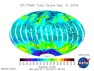
The Total Ozone Mapping Spectrometer (TOMS) was a NASA satellite instrument, specifically a spectrometer, for measuring the ozone layer. Of the five TOMS instruments which were built, four entered successful orbit. The satellites carrying TOMS instruments were:

<span class="mw-page-title-main">Meteor (satellite)</span> Series of weather observation satellites launched by Russia

The Meteor spacecraft are weather observation satellites launched by the Soviet Union and Russia. The Meteor satellite series was initially developed during the 1960s. The Meteor satellites were designed to monitor atmospheric and sea-surface temperatures, humidity, radiation, sea ice conditions, snow-cover, and clouds. Between 1964 and 1969 a total of eleven Soviet Union Meteor satellites were launched.

<span class="mw-page-title-main">Seasat</span>

Seasat was the first Earth-orbiting satellite designed for remote sensing of the Earth's oceans and had on board one of the first spaceborne synthetic-aperture radar (SAR). The mission was designed to demonstrate the feasibility of global satellite monitoring of oceanographic phenomena and to help determine the requirements for an operational ocean remote sensing satellite system. Specific objectives were to collect data on sea-surface winds, sea-surface temperatures, wave heights, internal waves, atmospheric water, sea ice features and ocean topography. Seasat was managed by NASA's Jet Propulsion Laboratory and was launched on 27 June 1978 into a nearly circular 800 km (500 mi) orbit with an inclination of 108°. Seasat operated until 10 October 1978 (UTC), when a massive short circuit in the Agena-D bus electrical system ended the mission.

A scatterometer or diffusionmeter is a scientific instrument to measure the return of a beam of light or radar waves scattered by diffusion in a medium such as air. Diffusionmeters using visible light are found in airports or along roads to measure horizontal visibility. Radar scatterometers use radio or microwaves to determine the normalized radar cross section of a surface. They are often mounted on weather satellites to find wind speed and direction, and are used in industries to analyze the roughness of surfaces.

<span class="mw-page-title-main">QuikSCAT</span> Earth observation satellite

The NASA QuikSCAT was an Earth observation satellite carrying the SeaWinds scatterometer. Its primary mission was to measure the surface wind speed and direct over the ice-free global oceans via its effect on water waves. Observations from QuikSCAT had a wide array of applications, and contributed to climatological studies, weather forecasting, meteorology, oceanographic research, marine safety, commercial fishing, tracking large icebergs, and studies of land and sea ice, among others. This SeaWinds scatterometer is referred to as the QuikSCAT scatterometer to distinguish it from the nearly identical SeaWinds scatterometer flown on the ADEOS-2 satellite.

<span class="mw-page-title-main">Atmospheric chemistry observational databases</span> Aspect of atmospheric sciences

Over the last two centuries many environmental chemical observations have been made from a variety of ground-based, airborne, and orbital platforms and deposited in databases. Many of these databases are publicly available. All of the instruments mentioned in this article give online public access to their data. These observations are critical in developing our understanding of the Earth's atmosphere and issues such as climate change, ozone depletion and air quality. Some of the external links provide repositories of many of these datasets in one place. For example, the Cambridge Atmospheric Chemical Database, is a large database in a uniform ASCII format. Each observation is augmented with the meteorological conditions such as the temperature, potential temperature, geopotential height, and equivalent PV latitude.

<span class="mw-page-title-main">Global Change Observation Mission</span> JAXA project of long-term observation of Earth

GCOM, is a JAXA project of long-term observation of Earth environmental changes. As a part of Japan's contributions to GEOSS, GCOM will be continued for 10 to 15 years with observation and utilization of global geophysical data such as precipitation, snow, water vapor, aerosol, for climate change prediction, water management, and food security. On May 18, 2012, the first satellite "GCOM-W" was launched. On December 23, 2017, the second satellite "GCOM-C1" was launched.

<span class="mw-page-title-main">NOAA-15</span>

NOAA-15, also known as NOAA-K before launch, is an operational, polar-orbiting of the NASA-provided Television Infrared Observation Satellite (TIROS) series of weather forecasting satellite operated by National Oceanic and Atmospheric Administration (NOAA). NOAA-15 was the latest in the Advanced TIROS-N (ATN) series. It provided support to environmental monitoring by complementing the NOAA/NESS Geostationary Operational Environmental Satellite program (GOES).

POLDER is a passive optical imaging radiometer and polarimeter instrument developed by the French space agency CNES.

<span class="mw-page-title-main">Atmospheric infrared sounder</span> Science instrument on NASAs Aqua satellite

The atmospheric infrared sounder (AIRS) is one of six instruments flying on board NASA's Aqua satellite, launched on May 4, 2002. The instrument is designed to support climate research and improve weather forecasting.

<span class="mw-page-title-main">ADEOS II</span> Japanese Earth observation satellite

ADEOS II was an Earth observation satellite (EOS) launched by NASDA, with contributions from NASA and CNES, in December 2002. and it was the successor to the 1996 mission ADEOS I. The mission ended in October 2003 after the satellite's solar panels failed.

<span class="mw-page-title-main">Suomi NPP</span>

The Suomi National Polar-orbiting Partnership, previously known as the National Polar-orbiting Operational Environmental Satellite System Preparatory Project (NPP) and NPP-Bridge, is a weather satellite operated by the United States National Oceanic and Atmospheric Administration (NOAA). It was launched in 2011 and continues to operate in June 2022.

<span class="mw-page-title-main">Nimbus 7</span>

Nimbus 7 was a meteorological satellite. It was the seventh and last in a series of the Nimbus program.

<span class="mw-page-title-main">NOAA-21</span> NASA/NOAA satellite

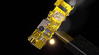
NOAA-21, designated JPSS-2 prior to launch, is the second of the United States National Oceanic and Atmospheric Administration (NOAA)'s latest generation of U.S. polar-orbiting, non-geosynchronous, environmental satellites called the Joint Polar Satellite System. NOAA-21 was launched on 10 November 2022 and join NOAA-20 and Suomi NPP in the same orbit. Circling the Earth from pole-to-pole, it will cross the equator about 14 times daily, providing full global coverage twice a day.

<span class="mw-page-title-main">NOAA-20</span> NASA satellite

NOAA-20, designated JPSS-1 prior to launch, is the first of the United States National Oceanic and Atmospheric Administration's latest generation of U.S. polar-orbiting, non-geosynchronous, environmental satellites called the Joint Polar Satellite System. NOAA-20 was launched on 18 November 2017 and joined the Suomi National Polar-orbiting Partnership satellite in the same orbit. NOAA-20 operates about 50 minutes behind Suomi NPP, allowing important overlap in observational coverage. Circling the Earth from pole-to-pole, it crosses the equator about 14 times daily, providing full global coverage twice a day. This gives meteorologists information on "atmospheric temperature and moisture, clouds, sea-surface temperature, ocean color, sea ice cover, volcanic ash, and fire detection" so as to enhance weather forecasting including hurricane tracking, post-hurricane recovery by detailing storm damage and mapping of power outages.

Nimbus 5 was a meteorological satellite for research and development of sensing technology. It was the fifth successful launch in a series of the Nimbus program.

NOAA-10, known as NOAA-G before launch, was an American weather satellite operated by the National Oceanic and Atmospheric Administration (NOAA) for use in the National Environmental Satellite Data and Information Service (NESDIS). It was the third of the Advanced TIROS-N series of satellites. The satellite design provided an economical and stable Sun-synchronous platform for advanced operational instruments to measure the atmosphere of Earth, its surface and cloud cover, and the near-space environment.

References

  1. "Launch Log". Jonathan's Space Report. 21 July 2021. Retrieved 29 October 2021.
  2. "ADEOS I 1996-046A 24277". NASA. 28 October 2021. Retrieved 29 October 2021.PD-icon.svg This article incorporates text from this source, which is in the public domain .
  3. 1 2 "ADEOS (Advanced Earth Observing Satellite) / Midori". ESA eoPortal Directory. 2021. Archived from the original on 21 July 2011. Retrieved 29 October 2021.
  4. "Advanced Visible and Near-Infrared Radiometer (AVNIR)". NASA. 28 October 2021. Retrieved 29 October 2021.PD-icon.svg This article incorporates text from this source, which is in the public domain .
  5. "Improved Limb Atmospheric Spectrometer (ILAS)". NASA. 28 October 2021. Retrieved 29 October 2021.PD-icon.svg This article incorporates text from this source, which is in the public domain .
  6. "Interferometric Monitor for Greenhouse Gases (IMG)". NASA. 28 October 2021. Retrieved 29 October 2021.PD-icon.svg This article incorporates text from this source, which is in the public domain .
  7. "NASA Scatterometer (NSCAT)". NASA. 28 October 2021. Retrieved 29 October 2021.PD-icon.svg This article incorporates text from this source, which is in the public domain .
  8. "Ocean Color and Temperature Scanner (OCTS)". NASA. 28 October 2021. Retrieved 29 October 2021.PD-icon.svg This article incorporates text from this source, which is in the public domain .
  9. "Polarization and Directionality of the Earth's Reflectance (POLDER)". NASA. 28 October 2021. Retrieved 29 October 2021.PD-icon.svg This article incorporates text from this source, which is in the public domain .
  10. "Retroreflector in Space (RIS)". NASA. 28 October 2021. Retrieved 29 October 2021.PD-icon.svg This article incorporates text from this source, which is in the public domain .
  11. "Total Ozone Mapping Spectrometer (TOMS)". NASA. 28 October 2021. Retrieved 29 October 2021.PD-icon.svg This article incorporates text from this source, which is in the public domain .