
Ceuta is an autonomous city of Spain on the north coast of Africa.

A municipality is usually a single administrative division having corporate status and powers of self-government or jurisdiction as granted by national and regional laws to which it is subordinate.

Baarle-Hertog is a Flemish municipality of Belgium, much of which consists of a number of small Belgian enclaves fully surrounded by the Netherlands.
Mainland is defined as "relating to or forming the main part of a country or continent, not including the islands around it [regardless of status under territorial jurisdiction by an entity]." The term is often politically, economically and/or demographically more significant than politically associated remote territories, such as exclaves or oceanic islands situated outside the continental shelf.

Freguesia, usually translated as "parish" or "civil parish", is the third-level administrative subdivision of Portugal, as defined by the 1976 Constitution. It is also the designation for local government jurisdictions in the former Portuguese overseas territories of Cape Verde and Macau. In the past, was also an administrative division of the other Portuguese overseas territories. The parroquia in the Spanish autonomous communities of Galicia and Asturias is similar to a freguesia.

In England, a civil parish is a type of administrative parish used for local government. It is a territorial designation which is the lowest tier of local government. Civil parishes can trace their origin to the ancient system of parishes, which for centuries were the principal unit of secular and religious administration in most of England and Wales. Civil and religious parishes were formally split into two types in the 19th century and are now entirely separate. Civil parishes in their modern form came into being through the Local Government Act 1894, which established elected parish councils to take on the secular functions of the parish vestry.

Vila Real de Santo António is a city, civil parish, and municipality in the Algarve, Portugal. The population in 2011 was 19,156, in an area of 61.25 km2. It is one of the few municipalities in Portugal without territorial continuity: its territory comprises two parts, with the municipal seat located in the eastern part. Vila Real de Santo António was founded after the 1755 Lisbon earthquake, and largely expanded in 1774 using the same architectural and construction techniques employed in the reconstruction of Lisbon after the disaster.

Steinstücken, with approximately 300 residents, is a small outlying neighborhood of the Wannsee district in the Berlin borough of Steglitz-Zehlendorf. From the division of Germany in 1949 until a connecting corridor was created in 1971–72, Steinstücken was the only permanently inhabited of twelve original exclaves of West Berlin in East Germany, while West Berlin itself was an enclave controlled by the Western Allies, surrounded by East German (GDR) territory.

The Counties Act 1844, which came into effect on 20 October 1844, was an Act of Parliament of the United Kingdom which eliminated many outliers or exclaves of counties in England and Wales for civil purposes. The changes were based on recommendations by a boundary commission, headed by the surveyor Thomas Drummond and summarized in a schedule attached to the Parliamentary Boundaries Act 1832. This also listed a few examples of civil parishes divided by county boundaries, most of which were dealt with by later legislation.

An enclave is a territory that is entirely surrounded by the territory of one other state or entity. Enclaves may also exist within territorial waters. Enclave is sometimes used improperly to denote a territory that is only partly surrounded by another state. Vatican City and San Marino, and Lesotho are completely enclaved sovereign states.

Bassella is a municipality in the comarca of the Alt Urgell, in Catalonia, Spain. The village of Bassella, one of nine settlements which make up the municipality, is located at the confluence of the Segre river with the Salada river and at the point where the route from Solsona and the potash mines of Cardona meets the route between Lleida and La Seu d'Urgell. The ajuntament is located in Castellnou de Bassella.

Majura Parish is a parish of Murray County, New South Wales, a cadastral unit for use on land titles. It is located to the east of the extreme eastern tip of the ACT. The Queanbeyan-Bungendore railway line and the Kings Highway pass through the parish. About a quarter of the original nineteenth-century parish was transferred to the ACT in 1909. The land transferred was the area between the railway line in the south and the watershed of the Molonglo River in the north. This cut off part of portion 210 of Majura Parish from the rest, giving the parish a small exclave.
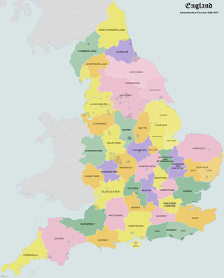
Administrative counties were subnational divisions of England used for local government from 1889 to 1974. They were created by the Local Government Act 1888, which established an elected county council for each area. Some geographically large historic counties were divided into several administrative counties, each with its own county council. The administrative counties operated until 1974, when they were replaced by a system of metropolitan and non-metropolitan counties under the Local Government Act 1972.
Simbor is a territory of 0.91 square kilometres located in the estuary of the Sahil River in the cove of Simbor, about 25 km east of Diu. Since its establishment in the early 18th century, this exclave was subordinate to the District of Diu, Portuguese India, until it was occupied by India in December 1961, along with the rest of Portuguese India. Simbor is now part of the District of Diu, one of the three districts of the union territory of Dadra and Nagar Haveli and Daman and Diu.

The Morocco–Spain land border consists of three non-contiguous lines totalling 18.5 km around the Spanish territories of Ceuta, Peñón de Vélez de la Gomera and Melilla. Spanish islets such as the Chafarinas or the Alhucemas are located off the Moroccan coast.
Taveiro, Ameal e Arzila is a civil parish in the municipality of Coimbra, Portugal. The population in 2021 was 3,997, in an area of 24.34 km2. It was formed on 28 January 2013 by the merging of freguesias Taveiro, Ameal, and Arzila. It's one of the few freguesias with an exclave.
