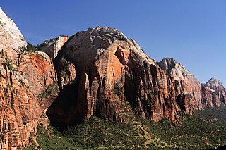
Zion Canyon is a deep and narrow gorge in southwestern Utah, United States, carved by the North Fork of the Virgin River. Nearly the entire canyon is located within the western half of Zion National Park.
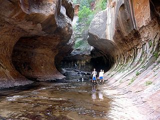
The Subway is a small, uniquely-shaped slot canyon within the Zion Wilderness in Zion National Park in northeastern Washington County, Utah, United States.
Zion National Park is an American national park located in southwestern Utah near the town of Springdale. A prominent feature of the 229-square-mile (590 km2) park is Zion Canyon, which is 15 miles (24 km) long and up to 2,640 ft (800 m) deep. The canyon walls are reddish and tan-colored Navajo Sandstone eroded by the North Fork of the Virgin River. The lowest point in the park is 3,666 ft (1,117 m) at Coalpits Wash and the highest peak is 8,726 ft (2,660 m) at Horse Ranch Mountain. Located at the junction of the Colorado Plateau, Great Basin, and Mojave Desert regions, the park has a unique geography and a variety of life zones that allow for unusual plant and animal diversity. Numerous plant species as well as 289 species of birds, 75 mammals, and 32 reptiles inhabit the park's four life zones: desert, riparian, woodland, and coniferous forest. Zion National Park includes mountains, canyons, buttes, mesas, monoliths, rivers, slot canyons, and natural arches.
Buckskin Mountain is a 16-mile (26 km) mountain ridge that spans from Coconino County, Arizona to Kane County, Utah in the United States, that is divided almost equally between the two counties.

Willis Creek is a creek in Bryce Canyon National Park, Dixie National Forest, and the Grand Staircase-Escalante National Monument in Garfield and Kane counties in southern Utah, United States. The creek rises in the national park in Garfield County, but quickly heads south out of the park to enter the national forest and Kane County. The course of the creek then curves to the east and enters the national monument, were it eventually runs through a wash, which in some sections narrows to become a slot canyon. The creek is popular with hikers as the stream is generally 1-2 inches deep and a trail runs the length of the creek. The end of the creek is dry.

The West Temple is a prominent 7,810-foot mountain summit composed of Navajo Sandstone in Zion National Park in Washington County of Utah, United States. This, the highest feature in Zion Canyon, was originally called "Temp-o-i-tin-car-ur" meaning "Mountain without a trail" by the Paiute people. It was called Steamboat Mountain by local Mormon settlers before 1934, when the USGS officially changed it to its present name, which was applied by John Wesley Powell during his explorations in 1872. West Temple is situated two miles northwest of Springdale, Utah, one mile northeast of Mount Kinesava, and two miles west of the park headquarters. It is one of the notable landmarks in the park. The nearest higher peak is Windy Peak, 10.46 miles (16.83 km) to the north. Precipitation runoff from the mountain drains into tributaries of the Virgin River.

The Watchman is a 6,545-foot (1,995 m) sandstone mountain summit located in Zion National Park, in Washington County of southwest Utah, United States.

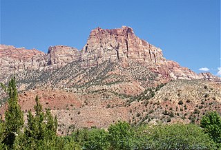
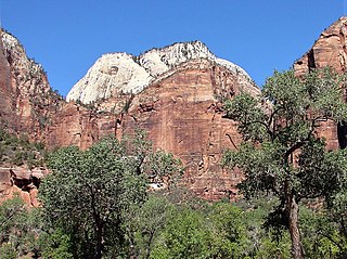
Mount Kinesava is a 7,285-foot (2,220 m) sandstone mountain summit located in Zion National Park, in Washington County of southwest Utah, United States.
Johnson Mountain is a 6,106-foot (1,861 m) Navajo Sandstone summit located in Zion National Park, in Washington County of southwest Utah, United States.

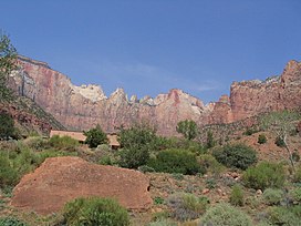
The Sentinel is a 7,120+ ft elevation Navajo Sandstone summit located near the Court of the Patriarchs in Zion National Park, in Washington County of southwest Utah, United States, that is part of the Towers of the Virgin. The national park map lists the elevation as 7,157-feet.

Cathedral Mountain is a 6,930-foot (2,110 m) elevation Navajo Sandstone summit located in Zion National Park, in Washington County of southwest Utah, United States.

Altar of Sacrifice is a 7,505-foot (2,288 m) Navajo Sandstone mountain in Zion National Park in Washington County, Utah, United States, that is part of the Towers of the Virgin.

Mountain of the Sun is a 6,722-foot (2,049 m) elevation Navajo Sandstone summit located in Zion National Park, in Washington County of southwest Utah, United States. Mountain of the Sun is situated immediately east of Court of the Patriarchs, and south of Zion Lodge, towering 2,500-feet above the lodge and the floor of Zion Canyon. It is set on the east side of the North Fork of the Virgin River which drains precipitation runoff from this mountain. Its neighbors include The Sentinel, Mount Spry, The East Temple, and Mount Moroni. This feature's name was officially adopted in 1934 by the U.S. Board on Geographic Names.
Red Arch Mountain is a 5,930-foot (1,810 m) elevation Navajo Sandstone summit located in Zion National Park, in Washington County of southwest Utah, United States.

The Sundial is a 7,590-foot elevation white Navajo Sandstone summit located in Zion National Park, in Washington County of southwest Utah, United States.
Castle Dome is a 7,054-foot (2,150 m) elevation Navajo Sandstone summit located in Zion National Park, in Washington County of southwest Utah, United States. Castle Dome is situated northwest of Zion Lodge, towering 2,800 feet (850 m) above the lodge and the floor of Zion Canyon. It is set on the west side of the North Fork Virgin River which drains precipitation runoff from this mountain. It is wedged between Behunin Canyon and Heaps Canyon, with the popular Emerald Pools set at the southeast foot of this mountain. Its neighbors include Mount Majestic, Cathedral Mountain, The Great White Throne, Red Arch Mountain, Mountain of the Sun, and Lady Mountain. This feature's name was officially adopted in 1934 by the U.S. Board on Geographic Names.

Meridian Tower is a 7,340-foot (2,240 m) Navajo Sandstone mountain in Zion National Park in Washington County, Utah, United States, that is part of the Towers of the Virgin

Three Marys are three sandstone pillars in Zion National Park in Washington County, Utah, United States.

The Witch Head is a 7,340-foot (2,240 m) white Navajo Sandstone mountain in Zion National Park in Washington County, Utah, United States, that is part of the Towers of the Virgin.

Deertrap Mountain is a 6,837-foot (2,084 m) mountain in Zion National Park in Washington County, Utah, United States.