
In geography and geology, a cliff or rock face is an area of rock which has a general angle defined by the vertical, or nearly vertical. Cliffs are formed by the processes of weathering and erosion, with the effect of gravity. Cliffs are common on coasts, in mountainous areas, escarpments and along rivers. Cliffs are usually composed of rock that is resistant to weathering and erosion. The sedimentary rocks that are most likely to form cliffs include sandstone, limestone, chalk, and dolomite. Igneous rocks such as granite and basalt also often form cliffs.

The Karakoram is a mountain range in the Kashmir region spanning the border of Pakistan, China, and India, with the northwestern extremity of the range extending to Afghanistan and Tajikistan. Most of the Karakoram mountain range falls under the jurisdiction of Gilgit-Baltistan, which is controlled by Pakistan. Its highest peak, K2, is located in Gilgit-Baltistan, Pakistan. It begins in the Wakhan Corridor (Afghanistan) in the west, encompasses the majority of Gilgit-Baltistan, Pakistan and extends into Ladakh and Aksai Chin. It is part of the larger Trans-Himalayan mountain ranges.

Muztagh Tower, also Mustagh Tower; Muztagh: icy mountain), is a mountain situated in Baltoro Muztagh, which is a segment of the Karakoram range. It straddles the border of the Gilgit–Baltistan region of Pakistan and the Xinjiang Uyghur Autonomous Region of China. Muztagh Tower is located between the basins of the Baltoro and Sarpo Laggo glaciers.

The Sarpo Laggo Glacier is a glacier in the autonomous region Xinjiang of China, in the Karakoram mountain range of the Himalayas.

Baltistan also known as Baltiyul or Little Tibet, is a mountainous region in the Pakistani-administered territory of Gilgit-Baltistan and constitutes a northern portion of the larger Kashmir region that has been the subject of a dispute between India and Pakistan since 1947. It is located near the Karakoram and borders Gilgit to the west, China's Xinjiang to the north, Indian-administered Ladakh to the southeast, and the Indian-administered Kashmir Valley to the southwest. The average altitude of the region is over 3,350 metres (10,990 ft). Baltistan is largely administered under the Baltistan Division.

The Trango Towers are a family of rock towers situated in the Gilgit-Baltistan region, in the northern part of Pakistan. The Towers have some of the world's largest cliffs and offer some of the most challenging big wall climbing opportunities. Each year, climbers from around the world embark on expeditions to the Karakoram region to climb these granite faces. The Trango Towers are situated to the north of the Baltoro Glacier and are part of the Baltoro Muztagh, which is a sub-range within the Karakoram mountain range. The highest point within the group is the summit of Great Trango Tower at 6,286 m (20,623 ft), the east face of which features the world's greatest nearly vertical drop.
The Baltoro Glacier is a glacier located in the Shigar District of the Gilgit-Baltistan region in Pakistan. It stretches for 63 km (39 mi) in length. It is one of the longest glaciers outside the polar regions. It is home to some of the world’s highest mountains. It runs through the Karakoram mountain range, close to K2, which is the second highest peak in the world, reaching an elevation of 8,611 meters. Within a 20-kilometer radius, there are three more mountains with elevations exceeding 8,000 meters.
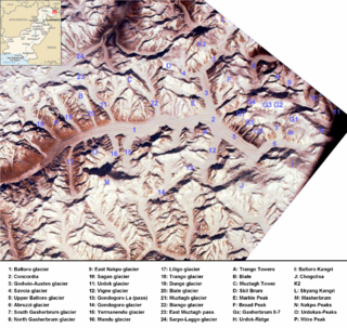
The Baltoro Muztagh is a subrange within the Karakoram mountain range. It spans across the Baltistan region of Gilgit-Baltistan, which is the northernmost political entity of Pakistan, and extends into Xinjiang, China. The crest of this range also serves as part of the border between Pakistan and China.

The Masherbrum Mountains are a subrange of the Karakoram mountains, located in Ghanche District in the Baltistan region of Pakistan-administered Kashmir.
Hainablak Glacier is a glacier near Trango Tower mountain in Baltistan, Gilgit-Baltistan, Pakistan.

Central Karakoram National Park is a national park located in Skardu district of Gilgit-Baltistan in Pakistan. It encompasses some of the world’s highest peaks and largest glaciers. Internationally renowned for mountaineering, rock climbing and trekking opportunities, it covers an area of about 10,000 sq. km and contains the greatest concentration of some of the tallest mountains on Earth. It has four peaks over 8,000 m including K2 (8611 m), Gasherbrum-I (8068 m), Gasherbrum-II (8035 m) and Broad Peak (8051 m), and sixty peaks higher than 7,000 m. The park was placed on the World Heritage Site Tentative List in 2016.

The Godwin-Austen Glacier is a glacier in the Karakoram range and is close to K2, the highest mountain peak in Pakistan and second highest on Earth, in Gilgit-Baltistan, Pakistan. Its confluence with the Baltoro Glacier is called Concordia and is a popular trekking destination as it provides views of four of the five eight-thousanders in the region.

The Saltoro Mountains form a subrange within the Karakoram Range and are situated in the southeastern part of the Karakoram. They lie on the southwest side of the Siachen Glacier, which is one of the two longest glaciers in the world outside the polar regions. The name "Saltoro" is also associated with the Saltoro Valley, located west of this range and descending on the Pakistani side of the Saltoro Range, which generally follows the Actual Ground Position Line (AGPL).

Baltoro Kangri is a mountain of the Karakoram mountain range in Gilgit-Baltistan, Pakistan. Baltoro Kangri is the 82nd highest mountain in the world with an elevation of 7,312 metres (23,990 ft). It lies to the south of the Gasherbrums and east of Chogolisa Peak. The huge Baltoro Glacier rises from the foot of Baltoro Kangri. On the northern side of Baltoro Kangri lies the Abruzzi Glacier.
The Mustagh Pass or Muztagh Pass is a mountain pass across the Baltoro Muztagh subrange within the Karakoram, which includes K2, the world's second highest mountain. The crest of the Baltoro Muztagh marks the present border between Pakistani and Chinese territory. Sarpo Laggo Pass is a 6,013-meter (19,728 ft)-high mountain pass at 35.8234°N 76.16249°E near Mustagh Pass.

The Braldu River flows in the Shigar District of Gilgit Baltistan in Pakistan. The Braldu River joins the Basha Basna River, and together they form the Shigar River, which is a tributary of the Indus River.

Kutiah Lungma Glacier is a glacier that stretches for approximately 12 km in length and has a width of about 3 km. It is situated within the Karakoram mountain range in the Stak Valley of District Skardu, Gilgit-Baltistan, Pakistan. This glacier is located in the Stak Valley, which is sometimes referred to as Staq, and it falls within the subdivision of Roundu in district Skardu, Gilgit-Baltistan.


