K2, also known as Mount Godwin-Austen or Chhogori, at 8,611 metres (28,251 ft) above sea level, is the second highest mountain in the world, after Mount Everest at 8,848 metres (29,029 ft). It is located on the China–Pakistan border between Baltistan in the Gilgit-Baltistan region of northern Pakistan, and the Taxkorgan Tajik Autonomous County of Xinjiang, China. K2 is the highest point of the Karakoram range and the highest point in both Pakistan and Xinjiang.

Makalu is the fifth highest mountain in the world at 8,485 metres (27,838 ft). It is located in the Mahalangur Himalayas 19 km (12 mi) southeast of Mount Everest, on the border between Nepal and Tibet, China. One of the eight-thousanders, Makalu is an isolated peak whose shape is a four-sided pyramid.
Gaurishankar is a mountain in the Himalayas, the second highest peak of the Rolwaling Himal, behind Melungtse (7,181m). The name comes from the Hindu goddess Gauri, a manifestation of Durga, and her Consort Shankar, denoting the sacred regard to which it is afforded it by the peoples of Tibet and Nepal. The Buddhist Sherpas call the mountain Jomo Tseringma. The Nepal Standard Time (GMT+05:45) is based on the meridian of this mountain peak.

Mount Hunter or Begguya is a mountain in Denali National Park in Alaska. It is approximately eight miles (13 km) south of Denali, the highest peak in North America. "Begguya" means child in the Dena'ina language. Mount Hunter is the third-highest major peak in the Alaska Range.

The Wetterstein mountains, also simply called the Wetterstein, is a mountain group in the Northern Limestone Alps within the Eastern Alps. It is a relatively compact range located between Garmisch-Partenkirchen, Mittenwald, Seefeld in Tirol and Ehrwald. Part of it is in the German free state of Bavaria and part in the Austrian federal state of Tyrol. The main summit of the Wetterstein, the Zugspitze, is also the highest mountain in Germany.

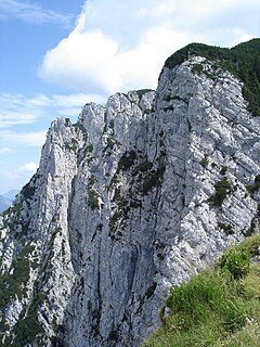
The Kaiser Mountains or just Kaiser, are a mountain range in the Northern Limestone Alps and Eastern Alps. It consists of two main mountain ridges – the Zahmer Kaiser to the north and the Wilder Kaiser to the south. The entire range is situated in the Austrian state of Tyrol between the town of Kufstein and the market town of St. Johann in Tirol. The Kaiser Mountains offer some of the loveliest scenery in all the Northern Limestone Alps.
The Petersköpfl is a 1,745m high summit in the Zahmer Kaiser, the northern ridge of the Kaisergebirge mountain range in the Austrian state of Tyrol. To the east the Petersköpfl is linked by a ridge to the Einserkogel, to the west it is separated from the Naunspitze by a wind gap. To the south it falls steeply into the Kaisertal valley and to the north its steep rock faces tower above Ebbs. To the east there is a gently sloping plateau covered with mountain pine that forms the main ridge of the Zahmer Kaiser and runs up to the Pyramidenspitze.
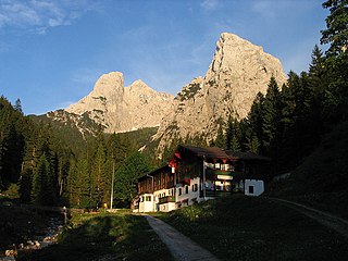
The Stripsenjochhaus is an Alpine club hut owned by the Kufstein branch of the Austrian Alpine Club in the Kaisergebirge mountain range in the Austrian state of Tyrol.
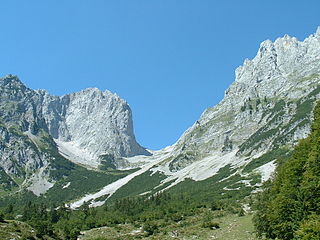
The Ellmauer Tor is a 2,000-metre high rock saddle in the middle of the Kaisergebirge in the Austrian state of Tyrol.
The Goinger Halt is a mountain in the Kaisergebirge range in the Northern Limestone Alps in Austria. It has a double summit: a northern top to the rear, the Hinterer Goinger Halt, and a higher, southern top in front, the Vorderer Goinger Halt. The name "Halt" means something like Alpine meadow and refers therefore to the peak over the meadow areas, that belong to the parish of Going.

The Hans Berger Haus is a refuge hut belonging to the Kufstein section of the Austrian Friends of Nature, located in the Kaisergebirge mountains in Tyrol. The tenants run a well-known climbing school here.
The Anton Karg Haus, formerly the Neue Hinterbärenbad Hut, is an Alpine club hut belonging to the Kufstein Section of the Austrian Alpine Club in the Kaisergebirge mountains in the Austrian state of Tyrol. The hut is named after the co-founder of the Kufstein Section, Anton Karg, who was the manager of the hut from 1888 and, from 1890 to 1919, the chairman of the Kufstein Branch of the Alpine Club.

The Grutten Hut is an Alpine club hut at a height of 1620 metres in the Kaisergebirge in Tyrol in Austria. It is owned by the Turner Alps Kränzchen Section of the German Alpine Club.

The Gaudeamus Hut is an Alpine club hut in the Kaisergebirge mountains in Tyrol. It is run by the Main-Spessart section of the German Alpine Club.

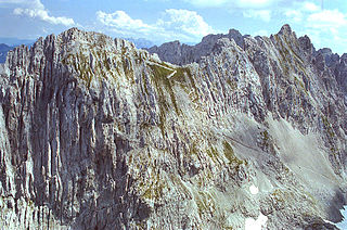
The Karlspitzen is a twin-peaked mountain in the middle of the Kaisergebirge range of the Northern Limestone Alps in Austria. The two peaks are the northern Hinteren Karlspitze and the southern Vorderen Karlspitze with its summit cross; they are linked by a sharp, exposed, rocky arête. Seen from the south the Vordere Karlspitze is a huge and very prominent block of rock, whereas the Hintere Karlspitze is hidden behind other (lower) neighbouring mountains.

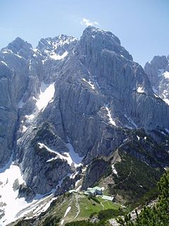
The Sonneck is a 2,260-metre-high (7,410 ft) mountain in the Kaisergebirge range of the Northern Limestone Alps in Austria. On its broad peak stands a solid summit cross, the panorama is comprehensive and there are particularly good views of the Ellmauer Halt, the highest mountain in the range, the Treffauer and Lake Hinterstein.
The Gleirscher Fernerkogel, also Gleirschfernerkogl, formerly called the Roßkarspitze, is a mountain, 3,189 m (AA), in the Southern Sellrain Mountains, a subgroup of the Stubai Alps. It rises in the Austrian state of Tyrol. The old name, Roßkarspitze, was given to it during the military survey of the region in the 1850s. The first documented ascent was undertaken on 1 September 1883 by Ludwig Purtscheller and Hans Schöller, a "professor from Salzburg". Purtscheller gave the mountain its present name. A prominent 500-metre-long ridge runs eastwards from the unimposing summit.