
The Midland Counties' Railway (MCR) was a railway company in the United Kingdom which existed between 1839 and 1844, connecting Nottingham, Leicester and Derby with Rugby and thence, via the London and Birmingham Railway, to London. The MCR system connected with the North Midland Railway and the Birmingham and Derby Junction Railway in Derby at what become known as the Tri Junct Station. The three later merged to become the Midland Railway.

The Ashby-de-la-Zouch Canal is a 31-mile (50 km) long canal in England which connected the mining district around Moira, just outside the town of Ashby-de-la-Zouch in Leicestershire, with the Coventry Canal at Bedworth in Warwickshire. It was opened in 1804, and a number of tramways were constructed at its northern end, to service collieries. The canal was taken over by the Midland Railway in 1846, but remained profitable until the 1890s, after which it steadily declined. Around 9 miles (14 km) passed through the Leicestershire coal field, and was heavily affected by subsidence, with the result that this section from Moira, southwards to Snarestone, was progressively closed in 1944, 1957 and 1966, leaving 22 miles (35 km) of navigable canal.

The Settle–Carlisle line is a 73-mile-long (117 km) main railway line in northern England. The route, which crosses the remote, scenic regions of the Yorkshire Dales and the North Pennines, runs between Settle Junction, on the Leeds–Morecambe line, and Carlisle, near the English-Scottish borders. The historic line was constructed in the 1870s and has several notable tunnels and viaducts such as the imposing Ribblehead.

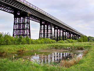
The Ribblehead Viaduct or Batty Moss Viaduct carries the Settle–Carlisle railway across Batty Moss in the Ribble Valley at Ribblehead, in North Yorkshire, England. The viaduct, built by the Midland Railway, is 28 miles (45 km) north-west of Skipton and 26 miles (42 km) south-east of Kendal. It is a Grade II* listed structure. Ribblehead Viaduct is the longest and the third tallest structure on the Settle–Carlisle line.

The Erewash Canal is a broad canal in Derbyshire, England. It runs just under 12 miles (19 km) and has 14 locks. The first lock at Langley Bridge is part of the Cromford Canal.
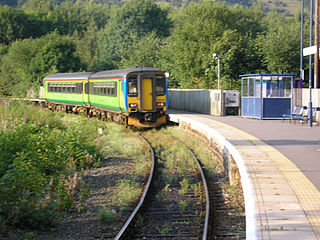
Ambergate railway station is a railway station owned by Network Rail and managed by East Midlands Railway. It serves the village of Ambergate in Derbyshire, England. The station is located on the Derwent Valley Line from Derby to Matlock, which diverges from the Midland Main Line just south of the station at Ambergate Junction.

The Birmingham and Derby Junction Railway was a British railway company. From Birmingham it connected at Derby with the North Midland Railway and the Midland Counties Railway at what became known as the Tri Junct Station. It now forms part of the main route between the West Country and the North East.
The Midland Railway of Canada was a historical Canadian railway which ran from Port Hope, Ontario to Midland on Georgian Bay. The line was originally intended to run to Peterborough, but the competing Cobourg and Peterborough Railway was completed in 1854 and the owner's plans changed. Redirecting the line northward, it opened as the Port Hope, Lindsay & Beaverton Railway, a much longer line than originally planned. A further expansion launched in 1869 pushed the line westward towards Georgian Bay, and prompted renaming as the Midland Railway.
Monsal Dale is a valley in Derbyshire, England, in the White Peak limestone area of the Peak District National Park. It is a Site of Special Scientific Interest (SSSI), a Special Area of Conservation (SAC) (1) and part of a Europe-wide network called Natura 2000.

Burton-on-Trent railway station is a mainline railway station located in the town of Burton upon Trent, Staffordshire, England. It is owned by Network Rail and managed by East Midlands Railway, although only CrossCountry services call at the station.
The Derbyshire and Staffordshire extension of the Great Northern Railway was an English railway network built by the GNR to get access to coal resources in the area to the north and west of Nottingham. The Midland Railway had obstructed the GNR in its attempts to secure a share of the lucrative business of transporting coal from the area, and in frustration the GNR built the line. The line was forked: it reached Pinxton in 1875 and a junction with the North Staffordshire Railway at Egginton, approaching Burton on Trent in 1878. The line cut through Derby, resulting in considerable demolition of housing there.
The Erewash Valley Line is a railway line in England, running from Long Eaton, located between Nottingham and Derby, and Clay Cross, near Chesterfield. The southern part was opened by the Midland Railway in 1847 as far as Codnor Park, where it connected to established ironworks, and soon after, a line to Pinxton and Mansfield.

Trent railway station was situated near Long Eaton in Derbyshire at the junction of the Midland Railway line from London to Derby and Nottingham. It was unusual in that it did not serve any community, being simply an interchange.
Andrew Handyside and Company was an iron founder in Derby, England, in the nineteenth century.

The Great Central Main Line (GCML), also known as the London Extension of the Manchester, Sheffield and Lincolnshire Railway (MS&LR), is a former railway line in the United Kingdom. The line was opened in 1899 and built by the Great Central Railway running from Sheffield in the North of England, southwards through Nottingham and Leicester to Marylebone in London.
Bennerley Viaduct is a former railway bridge, now a foot and cycle bridge, between Ilkeston, Derbyshire, and Awsworth, Nottinghamshire, in central England. It was completed in 1877 and carried the Great Northern Railway's (GNR) Derbyshire Extension over the River Erewash, which forms the county boundary, and its wide, flat valley. The engineer was Samuel Abbott, who worked under Richard Johnson, the GNR's chief engineer. The site required a bespoke design as the ground would not support a traditional masonry viaduct due to extensive coal mining. The viaduct consists of 16 spans of wrought iron, lattice truss girders, carried on 15 wrought iron piers which are not fixed to the ground but are supported by brick and ashlar bases. The viaduct is 60 feet high, 26 feet wide between the parapets, and over a quarter of a mile long. It was once part of a chain of bridges and embankments carrying the railway for around two miles across the valley but most of its supporting structures were demolished when the line closed in 1968. The only similar surviving bridge in the United Kingdom is Meldon Viaduct in Devon.

The River Don Navigation was the result of early efforts to make the River Don in South Yorkshire, England, navigable between Fishlake and Sheffield. The Dutch engineer Cornelius Vermuyden had re-routed the mouth of the river in 1626, to improve drainage, and the new works included provision for navigation, but the scheme did not solve the problem of flooding, and the Dutch River was cut in 1635 to link the new channel to Goole. The first Act of Parliament to improve navigation on the river was obtained in 1726, by a group of Cutlers based in Sheffield; the Corporation of Doncaster obtained an Act in the following year for improvements to the lower river. Locks and lock cuts were built and by 1751 the river was navigable to Tinsley.
The Ambergate, Nottingham and Boston and Eastern Junction Railway was a British railway company, which hoped to connect Lancashire with the port of Boston, in Lincolnshire, England. It was authorised in 1846 but was unable to raise much money. It opened a standard gauge line from a junction near Nottingham to Grantham in 1853. At Nottingham it was to rely on the Midland Railway, but that company was hostile and obstructive.
The Stockport, Disley and Whaley Bridge Railway was an early railway company in England which was opened in 1857 between Stockport Edgeley and Whaley Bridge.

The Midland Counties Railway viaduct is a disused railway viaduct at Rugby, Warwickshire, which crosses over both the A426 Rugby to Leicester road, and the River Avon to the north of Rugby town centre.


