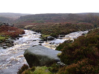
The River Etherow is a river in northern England, and a tributary of the River Goyt. Although now passing through South Yorkshire, Derbyshire and Greater Manchester, it historically formed the ancient county boundary between Cheshire and Derbyshire. The upper valley is known as Longdendale. The river has a watershed of approximately 30 square miles (78 km2), and the area an annual rainfall of 52.5 inches (1,330 mm).

The Upper Goyt Valley is the southern section of the valley of the River Goyt in North West England.

Belvide Reservoir is a reservoir in South Staffordshire, England. It was built in 1833 to supply the Birmingham and Liverpool Junction Canal, and has been managed as a nature reserve since 1977. It has been used to study the effect of water level changes on bird populations.

Grafham Water is an 806.3-hectare (1,992-acre) biological Site of Special Scientific Interest (SSSI) north of Perry, Huntingdonshire. It was designated an SSSI in 1986. It is a reservoir with a circumference of about 16 km (10 mi), is 21 m (69 ft) deep at maximum, and is the eighth largest reservoir in England by volume and the third largest by area at 6.27 km2. An area of 114 ha at the western end is a nature reserve managed by the Wildlife Trust for Bedfordshire, Cambridgeshire and Northamptonshire.

The Brent Reservoir is a reservoir in North West London. It straddles the boundary between the boroughs of Brent and Barnet and is owned by the Canal & River Trust. The reservoir takes its informal name from a public house called The Welsh Harp, which stood nearby until the early 1970s. It is a 68.6-hectare (170-acre) biological Site of Special Scientific Interest (SSSI), the only SSSI in either borough and among more than 30 SSSIs in Greater London.

Agden Reservoir is a water storage reservoir, situated at grid reference SK260925, 6.5 miles (10 km) west of the centre of Sheffield, South Yorkshire, England. It is owned by Yorkshire Water / Kelda Group. The reservoir covers an area of 25 hectares (62 acres) and has a capacity of 559 million gallons (2.11x10⁹ litres) of water, the dam wall has a width of approximately 380 feet (120 m) with a height of 100 feet (30 m). 'Agden' means 'Valley of the Oak Trees'.

Langsett Reservoir is in Yorkshire, England, near the villages of Langsett and Upper Midhope, on the edge of the Peak District National Park. The reservoir was constructed between 1898 and 1904, and is now managed by Yorkshire Water. Fed by the Little Don or Porter River, it is around a mile long, and supplies water for Sheffield and Barnsley via the Langsett Treatment Works.

The Wyming Brook is a river in the City of Sheffield, England. Its source is the Redmires Reservoirs near the Hallam Moors. It flows in a north-easterly direction for over 0.6 miles (1 km) down quite steep terrain into an underground chamber where it joins the Rivelin tunnel before it flows into the lower of the Rivelin Dams. There is a path that runs alongside the brook which is popular with walkers. The path can be quite steep, with it and the brook falling over 100 m in a kilometre. The river flows almost its entire length within the Wyming Brook Nature Reserve, which is managed by the Wildlife Trust for Sheffield and Rotherham. The surrounds are wooded near the bottom and more open near the top, with stunning views of the Rivelin Valley and beyond. Wildlife found around Wyming Brook includes the dipper and the crossbill. The Peak District Boundary Walk runs through the nature reserve.

The Redmires Reservoirs are a group of three reservoirs in Fulwood, Sheffield, South Yorkshire, England. They are fed from the Hallam Moors by various small streams including Fairthorn Clough. The three reservoirs are named Upper, Middle and Lower and were built between 1833 and 1854 to provide clean drinking water via an open water course which led to the Hadfield Dam situated in Crookes, following the devastating Sheffield cholera epidemic of 1832. The dams were built as part of the Sheffield Water Works continuing expansion to meet the ever growing population of Sheffield.

Tegg's Nose is a hill east of Macclesfield in Cheshire, England. It has a short ridge with a high point of 380 metres (1246 feet) at SJ947725, terminating in a promontory at the southern end. It lies on the western edge of the Peak District, although outside the boundary of the national park. Much of the hill's area falls within the Tegg's Nose Country Park, managed by Cheshire East Council Countryside Management Service; Tegg's Nose is also part of the Environmentally Sensitive Area Scheme.

Macclesfield Forest is an area of woodland, predominantly conifer plantation, located around 3 mi (5 km) south east of Macclesfield in the civil parish of Macclesfield Forest and Wildboarclough, in Cheshire, England. The existing woodland is the last substantial remnant of the Royal Forest of Macclesfield, a once-extensive ancient hunting reserve. The area also includes two reservoirs, Trentabank and Ridgegate. Macclesfield Forest lies on the western edge of the Peak District, within the South West Peak, and is partly inside the boundary of the National Park. The hills of Tegg's Nose and Shutlingsloe stand to the north west and south east, respectively; the moorland of High Moor lies to the south and the Goyt Valley lies to the west. Nearby villages include Langley and Wildboarclough.

Prestwick Carr is a large area of low-lying wetland on the northern boundary of the city of Newcastle upon Tyne in northeastern England between Dinnington and Ponteland. It is known for attracting various birds of wetlands and open country and is an Site of Special Scientific Interest and a nature reserve managed by the Northumberland Wildlife Trust. A large part of the site is owned by the Ministry of Defence.

The Supawna Meadows National Wildlife Refuge is a component of the Delaware River estuary in Salem County, New Jersey, it is just north of the Salem River and south of Pennsville.

Tring Reservoirs is a group of four reservoirs close to Tring on the border of Hertfordshire and Buckinghamshire, England. Their purpose is to feed the Grand Union Canal.

Portrack Marsh Nature Reserve is a 50 acres (20 ha) reserve by the northern bank of the River Tees between the Tees Barrage and the Tees Viaduct, near Portrack housing estate in Stockton-on-Tees borough, County Durham. It is the last remaining wetland on the lower Tees. The site is bounded by Marston Road, a disused railway line, the Northumbrian Water's waste water treatment site, the River Tees, the Tees Barrage White Water Course, the grounds of The Talpore pub and a Tees Barrage access road.

Edgehills Bog is a 0.66-hectare (1.6-acre) nature reserve in Gloucestershire in the Forest of Dean.

Walthamstow Wetlands is a 211 ha nature reserve in Walthamstow, east London, adjacent to the historic Essex-Middlesex border on the River Lea. It is focused on the Walthamstow Reservoirs, built by the East London Waterworks Company between 1853 and 1904 as part of the Lee Valley Reservoir Chain. The site is one of the largest urban wetland nature reserves in Europe and is particularly important for wildlife due to its position within the Lee Valley. It serves as a byway for migrating, wintering and breeding birds. Visitors can freely access the site's natural, industrial and social heritage in one of the capital's most densely populated urban areas.

Masani barrage, also Masani bridge, a barrage on the seasonal Sahibi River completed in 1989, is named after the Masani village in Rewari District of Haryana in India. Masani barrage also serves as a bridge on NH 919. Water storage in the barrage was made perennial in 2017 after a gap of 50 years. This barrage is important part of ecological corridor along the route of Sahibi river which traverses from Aravalli hills in Rajasthan to Yamuna via Matanhail forest, Chhuchhakwas-Godhari, Khaparwas Wildlife Sanctuary, Bhindawas Wildlife Sanctuary, Outfall Drain Number 8 and 6, Sarbashirpur, Sultanpur National Park, Basai and The Lost Lake (Gurugram).
McArthur Lake is a reservoir in Boundary County, Idaho, USA. It gives its name to the McArthur Lake Wildlife Corridor, which provides a bridge for wildlife to migrate between two mountainous areas. The reservoir and surrounding wetlands are rich in bird life, and are protected by the McArthur Lake Wildlife Management Area. There has been discussion about removing the dam that impounds the reservoir, which would improve the wetlands so they would support larger numbers of game birds, and would also improve the quality of water downstream.

Mere Sands Wood is a 105 acres (42 ha) nature reserve between the villages of Holmeswood and Rufford in west Lancashire, England, managed by The Wildlife Trust for Lancashire, Manchester & North Merseyside. It lies about five miles from Ormskirk. The name derives from when the area was on the shore of Martin Mere.


