Triglav Lodge at Kredarica

Last updated
Triglav Lodge at Kredarica
Slovenia relief map.png
Red triangle with thick white border.svg
Triglav Lodge at Kredarica
Highest point
Elevation 2,515 m (8,251 ft)
Coordinates 46°22′44.11″N13°50′55.75″E / 46.3789194°N 13.8488194°E / 46.3789194; 13.8488194
Naming
Native nameTriglavski dom na Kredarici (Slovene)
Geography
Location Slovenia
Parent range Julian Alps

The Triglav Lodge at Kredarica (Slovene : Triglavski dom na Kredarici) (2,515 m) is the highest mountain hut in Slovenia and the highest meteorological station in the country. It stands on a small plateau just under the peak of Kredarica, an elevation in the ridge between Rjavina and Triglav. The Valentin Stanič Lodge (Dom Valentina Staniča) stands to the northeast below Begunje Peak (Begunjski vrh, 2,460 m), and the Planika Lodge at Triglav (Dom Planika pod Triglavom) stands to the south. In the vicinity there is also a chapel dedicated to Our Lady of the Snows, and a few metres away there is a small cave named Ivačič Cave.

Contents

History

Opening of the lodge in 1896 Otvoritev Triglavske koce, 1896.jpg
Opening of the lodge in 1896

The first hut, named the Triglav Hut (Triglavska koča), was built in 1896 at the initiative of Jakob Aljaž. Later it was expanded three times, and it is now one of the largest mountain lodges in Slovenia. It can accommodate 200 hikers or more. In 1909, the Ljubljana Matica Alpine Club expanded the hut and renamed it the Triglav Lodge (Triglavski dom). In 1954, it was expanded again due to the increased number of visits after World War II. It was expanded for the last time in 1983.

Operation

The lodge is open to visitors all year round. Most visitors come from the end of June to the end of September. Outside the main season the residential meteorologists handle the visitors. The hut is managed by Ljubljana Matica Alpine Club. There is no cable car, and the hut is supplied by helicopters of the Slovenian Armed Forces.

The Ljubljana Matica Alpine Club's goal is to reduce the environmental impact of the hut. In 1992 they built a photovoltaic power station and in 1998 a small wind turbine. In 1992 they set up a base station and repaired the telephone line.

Weather station

Few meteorological stations in Slovenia can boast a longer period of operation than the one at Kredarica. It was built to provide more accurate weather forecasts, seeing as most weather fronts approach Slovenia from the west, and high-altitude measurements give insights that weather stations in the lowlands cannot provide. Ideally, the station would have been placed on Triglav itself, as it is the most prominent peak. Given the available resources, the best compromise was to locate the meteorological station by the existing mountain house at Kredarica; the exact location of the instruments is 15m away from the building.

The first meteorological observations were made in 1897, the year after the hut opened. The state meteorological service contributed meteorological instruments, while the caretaker of the hut, Anton Pekovec, recorded observations, only in the summers when the cottage was open.

In the early 20th century observations were carried out at Kredarica by a few university graduate meteorologists, with the intention of turning the meteorological station into an observatory. These plans did not materialize due to a lack of personnel and financial resources. By the mid 20th century, observations at Kredarica were handled by trained meteorological observers who were willing and able to spend the harsh winters at the mountain huts, as snow and weather conditions would prevent descent into the valley for weeks at a time.

Measurements at Kredarica have been continuous since August 1954. For the first four months it was solely a climatic station, but since January 1955 it has been one of Slovenia's first-order weather stations with a wide range of recorded meteorological measurements and observations. Since September 1994, the meteorological station has been fully automated. [1]

Due to the exceptional importance of the weather station at Kredarica, in the 21st century the Slovenian Armed Forces (SAF) have also become involved in meteorological observations. In 2005, the Slovenian Ministry of Defence and Environment Agency (ARSO) signed an agreement on monitoring the weather, snow structure and avalanches in the highlands. The SAF provides four meteorological observers and takes care of the helicopter transport of meteorologists to and from the weather station. Furthermore, in December 2020 the Chief of the General Staff, Robert Glavaš, and the Director General of ARSO, Iztok Slatinšek, signed a letter of intent to cooperate in the renovation and redevelopment of the facility at Kredarica. [2]

Since the mountain hut is located within the bounds of a natural park, the surroundings do not vary much due to human causes over time. As such, observations from Kredarica are included in the Global Climate Observing System, the purpose of which is to continuously monitor climate conditions around the world with the help of data from only the most accurate and carefully selected of measuring sites. [3]

Climate data for Kredarica, Slovenia (1991–2020 normals, extremes 1950–present)
MonthJanFebMarAprMayJunJulAugSepOctNovDecYear
Record high °C (°F)9.2
(48.6)
9.7
(49.5)
7.9
(46.2)
10.1
(50.2)
14.1
(57.4)
20.8
(69.4)
20.9
(69.6)
19.6
(67.3)
18.3
(64.9)
15.4
(59.7)
13.0
(55.4)
10.2
(50.4)
20.9
(69.6)
Average high °C (°F)−4.3
(24.3)
−4.9
(23.2)
−3.1
(26.4)
−0.6
(30.9)
3.3
(37.9)
7.5
(45.5)
10.0
(50.0)
10.2
(50.4)
6.3
(43.3)
3.7
(38.7)
−0.5
(31.1)
−3.5
(25.7)
2.0
(35.6)
Daily mean °C (°F)−7.0
(19.4)
−7.9
(17.8)
−5.9
(21.4)
−3.1
(26.4)
1.1
(34.0)
5.0
(41.0)
7.2
(45.0)
7.5
(45.5)
3.6
(38.5)
0.9
(33.6)
−3.0
(26.6)
−6.2
(20.8)
−0.7
(30.7)
Average low °C (°F)−9.5
(14.9)
−10.6
(12.9)
−8.4
(16.9)
−5.3
(22.5)
−0.9
(30.4)
2.8
(37.0)
4.9
(40.8)
5.3
(41.5)
1.4
(34.5)
−1.5
(29.3)
−5.3
(22.5)
−8.6
(16.5)
−3.0
(26.6)
Record low °C (°F)−28.3
(−18.9)
−28.1
(−18.6)
−28.2
(−18.8)
−20.5
(−4.9)
−15.7
(3.7)
−9.7
(14.5)
−6.0
(21.2)
−6.0
(21.2)
−9.9
(14.2)
−18.3
(−0.9)
−21.2
(−6.2)
−26.2
(−15.2)
−28.3
(−18.9)
Average precipitation mm (inches)89
(3.5)
96
(3.8)
121
(4.8)
141
(5.6)
162
(6.4)
206
(8.1)
218
(8.6)
206
(8.1)
236
(9.3)
236
(9.3)
216
(8.5)
131
(5.2)
2,059
(81.1)
Average extreme snow depth cm (inches)182
(72)
219
(86)
266
(105)
319
(126)
256
(101)
100
(39)
6
(2.4)
0
(0)
4
(1.6)
14
(5.5)
58
(23)
133
(52)
130
(51)
Average precipitation days (≥ 0.1 mm)121114161817171614141512175
Average snowy days (≥ 0 cm)312831303123417172631260
Average relative humidity (%) (at 14:00)65677583848380828073727076
Mean monthly sunshine hours 109.4111.4133.0130.9150.0158.2179.8160.1126.5123.289.2100.71,572.4
Source 1: Slovenian Environment Agency (humidity and snow 1981–2010) [4] [5]
Source 2: NOAA (sun 1991–2020) [6]

Starting points

Mountains

See also

Related Research Articles

<span class="mw-page-title-main">Geography of Slovenia</span>

Slovenia is situated at the crossroads of central and southeast Europe, touching the Alps and bordering the Adriatic Sea. The Alps—including the Julian Alps, the Kamnik–Savinja Alps and the Karawank chain, as well as the Pohorje massif—dominate northern Slovenia along its long border to Austria. Slovenia's Adriatic coastline stretches approximately 47 km (29 mi) from Italy to Croatia. Its part south of Sava river belongs to Balkan peninsula – Balkans.

<span class="mw-page-title-main">Triglav</span> Mountain in northwest Slovenia; highest peak of the Julian Alps

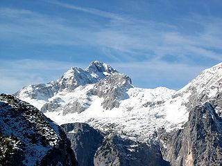
Triglav, with an elevation of 2,863.65 metres (9,395.2 ft), is the highest mountain in Slovenia and the highest peak of the Julian Alps. The mountain is the pre-eminent symbol of the Slovene nation. It is the centrepiece of Triglav National Park, Slovenia's only national park. Triglav was also the highest peak in Yugoslavia before Slovenia's independence in 1991.

<span class="mw-page-title-main">Aljaž Tower</span> Storm shelter in Mount Triglav summit

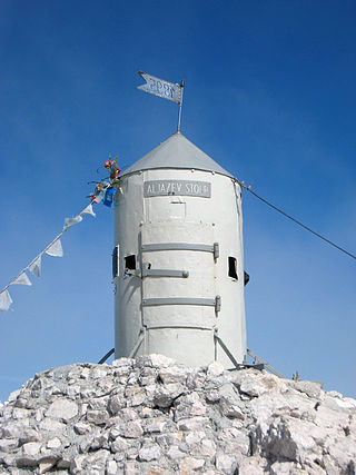
Aljaž Tower or the Triglav Tower is a tower, a storm shelter and a triangulation point on the summit of Mount Triglav in northwestern Slovenia. Along with Triglav, it is a landmark of Slovenia and a symbol of the Slovenehood. The tower was designed by Jakob Aljaž, a priest in the Upper Carniolan village of Dovje, who also had it erected. Today it is owned by the state, tended by the Ljubljana Matica Alpine Club and stands on a parcel belonging to the Municipality of Bohinj.

<span class="mw-page-title-main">Jakob Aljaž</span>

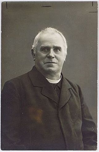
Jakob Aljaž was a Slovene Roman Catholic priest, composer and mountaineer.

<span class="mw-page-title-main">Triglav Lakes Valley</span> Valley in the Julian Alps, Slovenia

The Triglav Lakes Valley is a rocky hanging valley in the Julian Alps in Slovenia, below the sheer sides of Mount Tičarica and Mount Zelnarica southwest of Triglav. The valley is also called the Seven Lakes Valley, although there are ten and not seven lakes in the valley. It is above the tree line and is geologically alpine karst; therefore it has also been termed the Sea of Stone Valley.

<span class="mw-page-title-main">Krma</span>

Krma is an alpine valley in the Julian Alps in the Upper Carniola region of northwestern Slovenia. The entire valley lies in Triglav National Park.

The Ljubljana Matica Alpine Club, with its office located in Ljubljana, is by the number of members the largest Alpine club in Slovenia. In 2013, the club had about 2,800 members. It is a member of the Alpine Association of Slovenia. The current president of the club is Tomaž Willenpart.
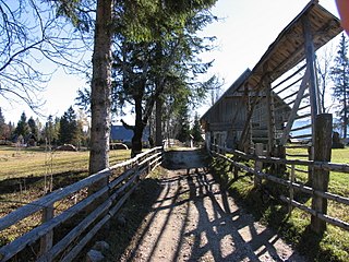
<span class="mw-page-title-main">Razor (mountain)</span> Mountain in Slovenia

Razor is a pyramidal mountain in the Julian Alps and the sixth-highest mountain in Slovenia. First ascended by Otto Sendtner in 1842, it is now frequently ascended, with numerous mountain huts available for climbers.

<span class="mw-page-title-main">Komna</span>

Komna is a mountain karst plateau in the Julian Alps in northwestern Slovenia. It has an elevation from 1,300 metres (4,300 ft) to 1,750 metres (5,740 ft). It has a triangular shape and rises above the Bohinj Basin. To the east, it continues into the Triglav Lakes Valley. The lowest measured temperatures in Slovenia were recorded at Komna in January 2009, reaching −49 °C (−56 °F).

<span class="mw-page-title-main">Lisca</span>

Lisca is a 948-metre (3,110 ft) hill in the eastern part of the Sava Hills in southeastern Slovenia, northwest of Sevnica, north of the Sava, and south of Gračnica Creek. It is the most frequently visited hiking destination in the Sava Hills.

<span class="mw-page-title-main">Municipality of Kranjska Gora</span> Municipality of Slovenia

The Municipality of Kranjska Gora is a municipality on the Sava Dolinka River in the Upper Carniola region of northwest Slovenia, close to the Austrian and Italian borders. The seat of the municipality is the town of Kranjska Gora.

The Slovenian Mountain Hiking Trail, sometimes also called Transverzala, is a route from Maribor to Ankaran. It covers most of the Slovenian mountain areas including Pohorje, the Julian Alps, the Kamnik-Savinja Alps, the Karawanks, and the southwestern part of Slovenia. It is the oldest hiking track in Europe.

<span class="mw-page-title-main">Triglav Lakes Lodge</span>

The Triglav Lakes Lodge is a mountain lodge between Double Lake and the artificial Lake Močivec below Mount Tičarica in the heart of the Julian Alps, northwestern Slovenia. The first structure was built in 1880 by an Austrian hiking club. In 1955 and 1988, it was rebuilt and expanded. It has four dining rooms with 150 seats, 13 rooms with 30 beds, and 13 larger sleeping rooms with 170 bunks. The lodge is open from the end of June until the start of October

<span class="mw-page-title-main">Ribnica Lodge</span>

The Ribnica Lodge is the highest mountain lodge in the Pohorje Mountains. It lies on a small plateau below Little Black Peak in the central area of the Pohorje Hills. The lodge is open all year round. It is accessible by car from Ribnica na Pohorju. There is also a small ski resort with three surface lifts.

<span class="mw-page-title-main">Planika Lodge at Triglav</span>

The Planika Lodge at Triglav is a mountain hut, which lies on the Ledine plains on the southern side of Mount Triglav. The First hut, also called the Triglav Tempe, was built on 18 September 1871. In 1877, the Austro-German hiking club built a hut called the Maria Theresa Hut. On 13 August 1911, there was another building added called the Maria Theresa Lodge. After World War I, the Slovenian Hiking club took over the hut and renamed it the Aleksander Lodge. The hut was transformed to a border garrison Karaula for a while. In 1945, the Gorje Hiking Club renamed it to Planika Lodge at Triglav. In 1987, Karaula was demolished and a bigger annex was built at its place on 19 August 1992.

<span class="mw-page-title-main">Aljaž Lodge in the Vrata Valley</span>

Aljaž Lodge in the Vrata Valley is a mountain hut that lies near the stream Triglav Bistrica in the upper end of the Vrata Valley. The hut is named after the Slovene priest and composer Jakob Aljaž (1845–1927), who in 1896 ordered the construction of the first wooden hut in the valley. The original Aljaž Lodge was built in 1904, and rebuilt in 1910 after the previous one was destroyed by an avalanche. Aljaž Lodge is the starting point to ascend the mountains Triglav, Škrlatica and Cmir.
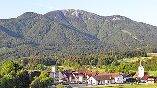
<span class="mw-page-title-main">Mount St. Ursula</span> Mountain in the country of Slovenia

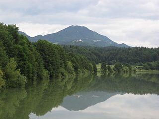
Mount St. Ursula or Plešivec is the easternmost peak of the Karawanks. It lies between the towns of Slovenj Gradec and Črna na Koroškem. There are three villages on the slopes of the mountain: Uršlja Gora, Podgora, and Zgornji Razbor. The mountain offers a panoramic view towards all of Carinthia, the Kozjak Mountains, and the Kamnik–Savinja Alps. Below the peak of Mount St. Ursula stands the Gothic St. Ursula's Church, a TV mast tower, a mountain lodge, 1,670 m or 5,480 ft), and a monument to the soldiers fallen in World War I.. The name Plešivec derives from its grey limestone peak.

Aljaž may refer to

<span class="mw-page-title-main">Mira Marko Debelak Deržaj</span> Slovenian mountaineer, translator, and opinion journalist

Mira "Marko" Debelak-Deržaj was a Slovenian alpinist, skier, and journalist, born December 26, 1904, in Sarajevo, and died September 27, 1948, Ljubljana.

<span class="mw-page-title-main">Triglav Bistrica</span> River in Slovenia

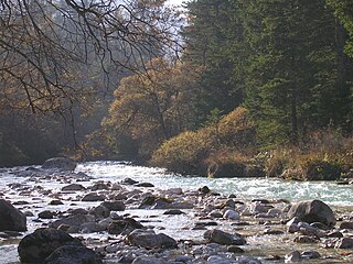
The Triglav Bistrica is a stream that flows through the glacial Vrata Valley southwest of Mojstrana, Slovenia. Its source is below the north face of Mount Triglav in the blind Bukovlje Valley, and it flows past the Aljaž Lodge. In addition to several intermittent tributaries with a flashy character, it also has three constant tributaries, all of them flowing from valleys below the east slope of Mount Škrlatica: Dry Creek, Red Creek, and Peričnik Creek. The Triglav Bistrica empties into the Sava Dolinka at Mojstrana. It falls 400 meters (1,300 ft) during its approximately 10-kilometer (6.2 mi) course.

References

  1. Cegnar, Tanja (August 2014). "60 YEARS OF METEOROLOGICAL STATION KREDARICA" (PDF). Slovenian Environment Agency - meteo.si. Retrieved 2022-07-26.
  2. "Slovenska vojska bo z ARSO sodelovala pri prenovi objekta na Kredarici | GOV.SI". Portal GOV.SI (in Slovenian). Retrieved 2022-07-26.
  3. Lengoasa, J. (2013-06-07). "List of Stations Comprising the Regional Basic Climatological Network (RBCN) in Region VI" (PDF). World Meteorological Organisation. Retrieved 2022-07-26.
  4. "Kredarica Podnebne statistike 1950-2020" (in Slovenian). Slovenian Environmental Agency. Archived from the original on 25 August 2023. Retrieved 25 August 2023.
  5. "Kredarica Climate Normals 1981-2010" (PDF). Slovenian Environmental Agency. Archived from the original (PDF) on 25 August 2023. Retrieved 25 August 2023.
  6. "Kredarica Climate Normals 1991–2020". World Meteorological Organization Climatological Standard Normals (1991–2020). National Oceanic and Atmospheric Administration. Archived from the original on 25 August 2023. Retrieved 25 August 2023.