Grintovec is the highest mountain of the Kamnik–Savinja Alps, with an elevation of 2,558 metres (8,392 ft). It is a popular location for hiking, climbing and skiing. The first recorded ascent was in 1759 by the botanist Giovanni Antonio Scopoli.
The Vršič Pass is a high mountain pass across the Julian Alps in northwestern Slovenia. It is the highest pass in Slovenia, with an elevation of 1,611 metres (5,285 ft), as well as the highest in the Eastern Julian Alps. It connects Upper Carniola with the Trenta Valley in the Slovene Littoral, and it is considered an excellent starting point for excursions to surrounding peaks. Over Vršič, there was an old trail, which was upgraded for military purposes as well as for logging and timber transportation in the early 20th century. The modern road, now known as the Russian Road, was built in 1915–17.

Kočna at 2,540 metres (8,330 ft) high, is the second-highest mountain in the Kamnik–Savinja Alps and the westernmost peak of the Grintovec Range. Its prominent and easily recognized peak is visible from far around. The mountain has two peaks: the higher Jezersko Kočna and the nearby lower Kokra Kočna.

Storžič is the highest mountain in the western part of the Kamnik–Savinja Alps. The top is a nicely shaped cone, from which the mountain got its name. Storžič has a good panoramic view. To the south are the Ljubljana Basin, Mount Krim, the Javornik Hills, Mount Snežnik, the Nanos Plateau, and the Škofja Loka Hills. To the west are the Julian Alps with prominent Mount Triglav. To the north are the Karawanks with Mount Stol, Mount Begunjščica, and Mount Košuta. To the east are the Jezersko Cirque, Mount Grintovec, the Kalce Ridge and Mount Krvavec.
Cold Mountain is a 2,203-meter (7,228 ft) mountain in the Kamnik Alps. Cold Mountain rises over three valleys: the Logar Valley, the Matk Cirque, and the Vellach Combe. It is rarely visited because it is relatively difficult to ascend with many exposed areas. The border with Austria runs along the northern and western side, and until 1967 it was difficult to access because of political problems. Its first climbers had problems scaling it. In 1876, Robert von Lendenfeld and a guide named Matijevec from Luče reached the western peak and they descended, thinking they had reached the highest peak. In 1877, Karl Blodig tried two times, but quit due to weather well below the top. In the same year Johannes Frischauf, Piskernik, and Matek finally conquered the top. The Frischauf Lodge on Okrešelj is named after him.

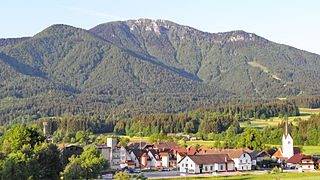
The Kalce Ridge is a 2,224-metre-high (7,297 ft) mountain of the Kamnik–Savinja Alps in northern Slovenia. It is the highest peak of the Krvavec Group.

The Kamnik Saddle Lodge is a mountain hostel located just below Kamnik Saddle, with Mount Brana to its west and Mount Planjava to its east, and the Kamnik Bistrica Valley to its south. On its north is a steep descent toward the Logar Valley, home to Rinka Falls.

The Triglav Lakes Lodge is a mountain lodge between Double Lake and the artificial Lake Močivec below Mount Tičarica in the heart of the Julian Alps, northwestern Slovenia. The first structure was built in 1880 by an Austrian hiking club. In 1955 and 1988, it was rebuilt and expanded. It has four dining rooms with 150 seats, 13 rooms with 30 beds, and 13 larger sleeping rooms with 170 bunks. The lodge is open from the end of June until the start of October

The Storžič Lodge is a mountain hostel in the upper part of the Lomščica Valley, near the Jesenje Pasture in northwestern Slovenia. The first lodge was built in 1938 and was called the Verbič Lodge ; it caught fire one year later. It burned in 1941 when German forces attacked the Storžič Battalion. The current brown shingled hut was built in 1951.

Raduha is a mountain in the eastern part of Kamnik–Savinja Alps in northern Slovenia.

The Ribnica Lodge is the highest mountain lodge in the Pohorje Mountains. It lies on a small plateau below Little Black Peak in the central area of the Pohorje Hills. The lodge is open all year round. It is accessible by car from Ribnica na Pohorju. There is also a small ski resort with three surface lifts.

The Smrekovec Lodge is a mountain hostel on the southern slope of the Smrekovec Mountains in the Kamnik–Savinja Alps. The first lodge was built in 1933, but it was burned down during World War II. A new lodge was built in 1951, and expanded in 1976–77.

The Zois Lodge at Kokra Saddle is a mountain hostel that stands on Kokra Saddle, part of the Kamnik–Savinja Alps. It is named after the brothers Karl Zois (1756–1799), and Sigmund Zois (1747–1819).
The Loka Lodge at Raduha is a mountain hostel that stands on the Loka Plateau in northern Slovenia. It is open from the start of June to the end of August.

The Kocbek Lodge at Korošica is a mountain lodge standing on the Korošica Pasture on the Dleskovec Plateau, below the southern slope of Mount Ojstrica. It is named after Fran Kocbek, an early promoter of mountain hiking in the Kamnik–Savinja Alps. The first lodge, which was built in 1876, burned in 1881. A year later a new one was built. During World War II, it was captured by the Germans. It was expanded and modified from 1969 to 1973. The lodge was destroyed by a fire on October 20, 2017.
The Frischauf Lodge at Okrešelj is a mountain lodge that stands above the Logar Valley in northern Slovenia. It is surrounded by the following peaks: Cold Mountain, Styria Mount Rinka, Carinthia Mount Rinka, and Mount Turska. Nearby is 80-meter (260 ft) Rinka Falls. The lodge is named after Johannes Frischauf, and the first lodge was built in 1876 by an Austro-German hiking club. In 1907 it was destroyed by an avalanche and rebuilt again in 1908. In 1991 it was expanded and modernized.

The Planika Lodge at Triglav is a mountain hut, which lies on the Ledine plains on the southern side of Mount Triglav. The First hut, also called the Triglav Tempe, was built on 18 September 1871. In 1877, the Austro-German hiking club built a hut called the Maria Theresa Hut. On 13 August 1911, there was another building added called the Maria Theresa Lodge. After World War I, the Slovenian Hiking club took over the hut and renamed it the Aleksander Lodge. The hut was transformed to a border garrison Karaula for a while. In 1945, the Gorje Hiking Club renamed it to Planika Lodge at Triglav. In 1987, Karaula was demolished and a bigger annex was built at its place on 19 August 1992.

Begunjščica is a ridge mountain in the Karawanks. It rises from the western Smokuč mountain pasture to St. Anne on its eastern side. The mountain has three main peaks, the highest being Big Peak. The western Middle Peak lies a little lower, and the lowest is Begunje Mount Vrtača. Its southern slopes rise over the Draga Valley. The ascent of the mountain is relatively easy and possible throughout the year. In the winter and early spring conditions are favourable for ski touring.
Mount St. Ursula or Plešivec is the easternmost peak of the Karawanks. It lies between the towns of Slovenj Gradec and Črna na Koroškem. There are three villages on the slopes of the mountain: Uršlja Gora, Podgora, and Zgornji Razbor. The mountain offers a panoramic view towards all of Carinthia, the Kozjak Mountains, and the Kamnik–Savinja Alps. Below the peak of Mount St. Ursula stands the Gothic St. Ursula's Church, a TV mast tower, a mountain lodge, 1,670 m or 5,480 ft), and a monument to the soldiers fallen in World War I.. The name Plešivec derives from its grey limestone peak.