Triponzo | |
|---|---|
Frazione | |
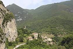 Panorama of Triponzo | |
 Triponzo | |
| Coordinates: 42°49′43″N12°56′13″E / 42.82861°N 12.93694°E Coordinates: 42°49′43″N12°56′13″E / 42.82861°N 12.93694°E | |
| Country | |
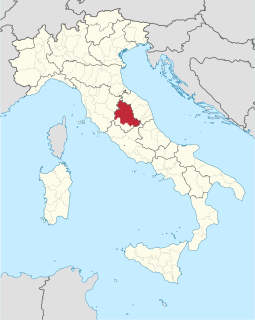
| Region | Umbria |
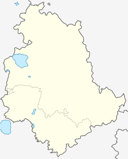
| Province | Perugia |
| Comune | Cerreto di Spoleto |
| Elevation | 420 m (1,380 ft) |
| Population (2001) [1] | |
| • Total | 45 |
| Time zone | UTC+1 (CET) |
| • Summer (DST) | UTC+2 (CEST) |
| Postcode | 06040 |
| Area code(s) | 0743 |
Triponzo is a frazione of the comune of Cerreto di Spoleto in the Province of Perugia, Umbria, central Italy. It stands at an elevation of 420 metres above sea level. At the time of the Istat census of 2001 it had 45 inhabitants. [1]
"Frazione" is the Italian name given in administrative law to a type of territorial subdivision of a comune; for other administrative divisions, see municipio, circoscrizione, quartiere. It is cognate to the English word fraction, but in practice is roughly equivalent to "parishes" or "wards" in other countries.

The comune is a basic administrative division in Italy, roughly equivalent to a township or municipality.

Cerreto di Spoleto is an Italian village and comune of the province of Perugia in Umbria. It is a dispersed rural community with 1,158 inhabitants spread over 8 frazioni. Its claim to fame is to be the root of the English term "charlatan", as Cerreto was once widely known for the quacks among its natives.
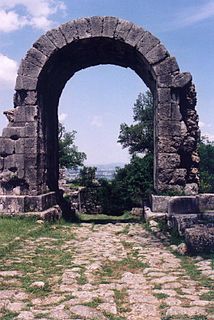
The name of the town must surely derive from Latin *Tripontium, meaning "three bridges", presumably one over each branch of the rivers; but no Roman bridge has survived. It is famous among epigraphers for a Roman inscription (CIL IX.4541 = ILLRP 1275a), carved in the live rock on the outer face of the modern SS 209 road tunnel a few hundred metres W of the town, which records the building of the Roman road from Spoletium to Nursia by order of the Roman Senate.
Epigraphy is the study of inscriptions, or epigraphs, as writing; it is the science of identifying graphemes, clarifying their meanings, classifying their uses according to dates and cultural contexts, and drawing conclusions about the writing and the writers. Specifically excluded from epigraphy are the historical significance of an epigraph as a document and the artistic value of a literary composition.

In historiography, ancient Rome is Roman civilization from the founding of the Italian city of Rome in the 8th century BC to the collapse of the Western Roman Empire in the 5th century AD, encompassing the Roman Kingdom, Roman Republic and Roman Empire until the fall of the western empire. The civilization began as an Italic settlement in the Italian Peninsula, conventionally founded in 753 BC, that grew into the city of Rome and which subsequently gave its name to the empire over which it ruled and to the widespread civilisation the empire developed. The Roman Empire expanded to become one of the largest empires in the ancient world, though still ruled from the city, with an estimated 50 to 90 million inhabitants ) and covering 5.0 million square kilometres at its height in AD 117.

The Roman Senate was a political institution in ancient Rome. It was one of the most enduring institutions in Roman history, being established in the first days of the city of Rome,. It survived the overthrow of the kings in 509 BC, the fall of the Roman Republic in the 1st century BC, the division of the Roman Empire in 395 AD, the fall of the Western Roman Empire in 476 AD, and the barbarian rule of Rome in the 5th, 6th, and 7th centuries.
Triponzo is also notable for at least one medieval church, S. Caterina, and sulphureous springs, about 1.5 km (1 mi) NE of town, the water of which is considered to have therapeutic properties: a combination spa and hydroelectric facility have been under construction here since the late 20th century.
The famous Valnerina (Valley of the Nera River) in Umbria was characterized by more than 50 medieval fortifications with watchtowers. Over the years, most of the towers were lost due to war and seismic events. The tower of Triponzo was the largest of these lying at the crux of two important valleys. Built in the 1300s it was badly damaged during the earthquake of September 1997. Given that it was one of the few remaining structures, the authorities expressed the desire to see it rebuilt in part to cancel traumatic events from memory however rebuilding the tower would have required its total demolition and removing the fallen parts would have meant an unacceptable risk for the workers. With the help of modern building technology, a new project was created by Architects Martin Stubenrauch, Moreno Orazi and Engineer Fabrizio Menghini. The fallen tower parts were stabilized, the facade preserved and a monumental modern steel spine was added to uphold and re-identify the monument in modern terms. Today the tower leaps into view upon approaching the town by roadway. The tower is unique in its bold approach to historic reconstruction.
- Images of Triponzo
 Borgo Triponzo and the road to Cerreto di Spoleto
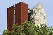 The castle ruin
 The church Santa Caterina
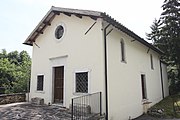 The church Madonna delle Grazie