
Prague is the capital and largest city of the Czech Republic and the historical capital of Bohemia. Situated on the Vltava river, Prague is home to about 1.4 million people.

Bohemians Praha 1905, commonly known as Bohemka, is a professional football club based in Vršovice, Prague, Czech Republic. The club competes in the Fortuna Liga, the top division in the Czech Republic football league system. Founded in 1905 as AFK Vršovice, the club won the 1982–83 Czechoslovak First League, its only league championship. Its colours are green and white.
Prague has a local-government structure of two or three tiers, depending on the area of town. At the top is the Magistrate of the Capital City of Prague, which is responsible for public transport; waste collection; municipal police; firefighting; ambulance services; cultural activities; care of historical sites; the Prague Zoo; and other activities of citywide significance.
Vinohrady is a cadastral district in Prague. It is so named because the area was once covered in vineyards dating from the 14th century. Vinohrady lies in the municipal and administrative districts of Prague 2, Prague 3 and Prague 10, little parts also of Prague 1 and Prague 4.

Prague Zoological Garden is a zoo in Prague, Czech Republic. It was opened in 1931 with the goal to "advance the study of zoology, protect wildlife, and educate the public" in the district of Troja in the north of Prague. In 2013, the zoo occupied 58 hectares with 50 hectares in use for exhibits, and housed around 5,000 animals from 676 species, including 132 species listed as threatened.

Smíchov is,since 1922, a district and cadastral area of Prague, the capital of the Czech Republic, and is part of Prague 5. It is on the west bank of the Vltava river.

Michle is a district of Prague city, part of Prague 4.

Nusle is a district of Prague. It became part of the city in 1922.

Jinonice is a cadastral district of Prague, mostly part of Prague 5, but a small area is part of Prague 13. It is located on the north edge of Prokopské údolí national park. Jinonice has been a part of Prague city since 1922.
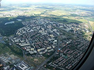
Prague 11 is a municipal district in Prague, Czech Republic. It is located in the south eastern part, 8 km from the City Center.

Vysočany is a part of Prague in the Prague 9 administrative district, Czech Republic. It lays in the eastern part of Prague around the valley with Rokytka river.History

Běchovice is a suburb of Prague, currently a municipal district in the administrative district Prague 21. It is located about 13 km east of the city centre. The main road and railway line connecting Prague and Kolín pass through Běchovice. The population as of 2008 was 4,038.

Prague 7 is a municipal district in Prague, Czech Republic.

Prague 8 is a municipal district in Prague, Czech Republic.

Prague 10 is both a municipal and administrative district in Prague, Czech Republic with more than 110,000 inhabitants.

Vinec is a municipality and village in Mladá Boleslav District in the Central Bohemian Region of the Czech Republic. It has about 300 inhabitants.

Vršovice is a cadastral district of Prague. All of Vršovice lies within the Prague 10 administrative district. Vršovice is located south-east of the city centre. It borders Vinohrady to the north, Nusle to the south-west, Michle to the south and Strašnice to the east. The name is first mentioned in 1088 in the founding document of the Vyšehrad Chapter. In 1922 the district was incorporated into the city of Prague. It has 107 streets and 1,611 addresses and has about 38,700 inhabitants.

Strašnice is a cadastral district in Prague. It became part of Prague on 1 January 1922. It lies mostly in the municipal and administrative district of Prague 10 while a small part is in Prague 3. The district is bordered by Vršovice, Vinohrady, Žižkov, Malešice, Hostivař, Záběhlice and Michle.

The Czech village of Štěrboholy was founded in 1371, and became part of Prague in 1968. Now it is its own cadastral area, part of the administrative district Prague 10.

Malešice is a cadastral district in Prague. The earliest reference about the village is from 1309. It became a part of Prague on 1 January 1922. It lies mostly in the administrative district of Prague 10 while a small part is in Prague 9. The district is bordered by Strašnice, Žižkov, Hrdlořezy, Kyje, Štěrboholy and Hostivař. The population is over 11,000 as of the 2021 census.

