Logan County is a county in the southwest Pennyroyal Plateau area of the U.S. Commonwealth of Kentucky. As of the 2020 census, the population was 27,432. Its county seat is Russellville.

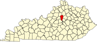
Kenton County is a county located in the northern part of the Commonwealth of Kentucky. As of the 2020 census, the population was 169,064, making it the third most populous county in Kentucky. Its county seats are Covington and Independence. It was, until November 24, 2010, the only county in Kentucky to have two legally recognized county seats. The county was formed in 1840 and is named for Simon Kenton, a frontiersman notable in the early history of the state.

Harrison County is a county located in the U.S. state of Kentucky. As of the 2020 census, the population was 18,692. Its county seat is Cynthiana. The county was founded in 1793 and named for Colonel Benjamin Harrison, an advocate for Kentucky statehood, framer of the Kentucky Constitution, and Kentucky legislator.
Campbell County is a county located in the northern part of the U.S. state of Kentucky. As of the 2020 census, the population was 93,076. Its county seats are Alexandria and Newport. The county was formed on December 17, 1794, from sections of Scott, Harrison, and Mason Counties and was named for Colonel John Campbell (1735–1799), a Revolutionary War soldier and Kentucky legislator. Campbell County, with Boone and Kenton Counties, is part of the Northern Kentucky metro community, and the Cincinnati-Middletown, OH-KY-IN Metropolitan Statistical Area.

Jackson is a home rule-class city in and the county seat of Breathitt County, Kentucky, in the United States. The population was 2,231 according to the 2010 U.S. census.

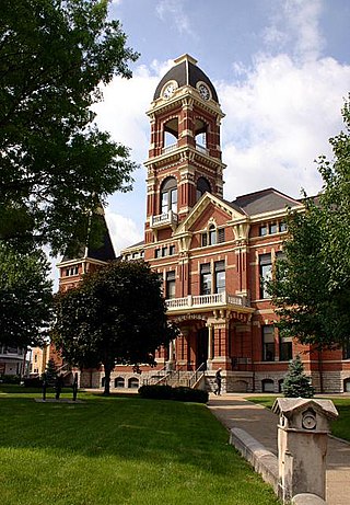
Erlanger is a home rule-class city in Kenton County, Kentucky, United States. It had a 2010 census population of 18,368. Erlanger is part of the Cincinnati-Middletown, OH-KY-IN Metropolitan Statistical Area.

Lebanon is a home rule-class city and the county seat of Marion County, Kentucky, in the United States. The population was 5,539 at the 2010 census. Lebanon is located in central Kentucky, southeast of Louisville. A national cemetery is located nearby.

Sparta is a home rule-class city in Gallatin and Owen counties in the U.S. state of Kentucky. The population was 231 at the 2010 census.

Kentucky Route 11 (KY 11) is an American highway maintained by the Kentucky Transportation Cabinet that runs from Maysville to Barbourville. The route from Maysville to Mount Sterling is being upgraded on a new alignment as part of a "macro-corridor" within the state of Kentucky.

Kentucky Route 70 (KY 70) is a long east-east state highway that originates at a junction with U.S. Route 60 (US 60) in Smithland in Livingston County, just east of the Ohio River. The route continues through the counties of Crittenden, Caldwell, Hopkins, Muhlenberg, Butler, Edmonson, Barren, Barren, Metcalfe, Green, Taylor, Casey, Pulaski, Lincoln and back into Pulaski again to terminate at a junction with US 150 near Maretburg in Rockcastle.

Kentucky Route 33 is a 32.094-mile-long (51.650 km), two-lane, north–south state highway in Kentucky managed by the Kentucky Transportation Cabinet.

"My Town" is a song written by Reed Nielsen and Jeffrey Steele and recorded by American country music duo Montgomery Gentry. It was released in June 2002 as the lead-off single and title track to their album of the same name. It peaked on the U.S. country chart at #5 and also peaked at #40 on the Billboard Hot 100, making it one of their highest peaking crossover singles.

State Route 21 is a two lane highway that runs from the Mississippi River west of Tiptonville, Tennessee to the Kentucky state line north of Union City. This road provides access to Reelfoot Lake State Park.
Fourmile is an unincorporated community located in Bell County, Kentucky.
Aberdeen is an unincorporated community and coal town located in Butler County, Kentucky, United States.

The Illinois–Indiana–Kentucky tri-state area is a tri-state area where the U.S. states of Illinois, Indiana, and Kentucky intersect. The area is defined mainly by the television viewing area and consists of ten Illinois counties, eleven Indiana counties, and nine Kentucky counties, centered upon the Ohio and Wabash Rivers.

Kentucky Route 85 (KY 85) is a 33.150-mile-long (53.350 km) state highway in Kentucky that runs from Kentucky Route 70 east of Madisonville to U.S. Route 62 northeast of Rockport via Sacramento and Centertown.

The Cincinnati metropolitan area is a metropolitan area centered on Cincinnati and including surrounding counties in the U.S. states of Ohio, Kentucky, and Indiana. The area is commonly known as Greater Cincinnati.