
The Meža (Slovene) or Mieß is a river in the Austrian state of Carinthia and in Slovenia, a right tributary of the Drava. It is 43 kilometers (27 mi) long, of which 42 kilometers (26 mi) are in Slovenia. Its catchment area is 551.7 square kilometers (213.0 sq mi), of which 543 square kilometers (210 sq mi) in Slovenia.

The Karawanks or Karavankas or Karavanks are a mountain range of the Southern Limestone Alps on the border between Slovenia to the south and Austria to the north. With a total length of 120 kilometres (75 mi) in an east–west direction, the Karawanks chain is one of the longest ranges in Europe. It is traversed by important trade routes and has a great tourist significance. Geographically and geologically, it is divided into the higher Western Karawanks and the lower-lying Eastern Karawanks. It is traversed by the Periadriatic Seam, separating the Apulian tectonic plate from the Eurasian Plate.
The Kamnik–Savinja Alps are a mountain range of the Southern Limestone Alps. They lie in northern Slovenia, except for the northernmost part, which lies in Austria.
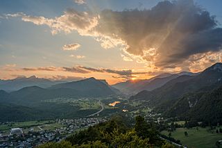
Jesenice is the tenth-largest town in Slovenia, located in the traditional province of Upper Carniola. It is the seat of the Municipality of Jesenice spanning the southern side of the Karawanks, along Slovenia's border with Austria to the north. Renowned as a mining town, its ironworks and metallurgy industries being the driving force of the town's historical development.

Seeberg Saddle, also just Seeberg (Jezersko) is a high mountain pass connecting Bad Eisenkappel in the Austrian state of Carinthia with Jezersko in the Slovenian region of Carinthia. It is located in the Southern Limestone Alps, between the Karawanks range in the west and the Kamnik–Savinja Alps in the east.

Lake Faak is a lake in the Austrian state of Carinthia. With an area of approximately 2.2 km2 (0.85 sq mi), it is the state's fifth-largest lake.
Bobotov Kuk is a peak in northern Montenegro. At 2,523 m (8,278 ft), it is the highest peak in the Durmitor mountain range and had been thought to be the highest point in Montenegro. New surveys have shown there are three higher peaks on the border with Albania. Most Montenegrin mountains are visible from Bobotov Kuk, among them Lovćen, Kopaonik and Tara, Maglić.

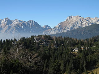
Golica is a peak in the Western Karawanks, on the border between Slovenia and Austria, above the Slovene town of Jesenice. It is known mainly for its fields of wild white narcissi, swathes of which cover Golica and surrounding pastures in late April and early May. This marks the beginning of a popular time for mountaineers to visit, extending through the end of summer. The slopes provide great views of the Julian Alps and Austrian Carinthia; the Ljubljana Basin can be seen from the summit on clear days.

Stol or Hochstuhl, at 2,236 m (7,336 ft), is the highest mountain of the Karawanks and straddles the border between Slovenia and Austria.
Rožca is a grassy high-elevation mountain pass over the western Karawanks. The saddle is located between Hrušica Peak and Mount Klek, and straddles the border between Slovenia and Austria, above the town of Jesenice. Its slopes serve as sheep pastures.
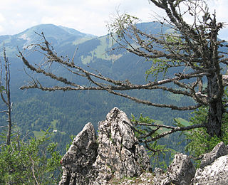
Klek, also known as Petelin or Petelinjek to locals from the villages on the Slovene side below its summit, is a peak in the Western Karawanks, between Golica/Kahlkogel to the east and Dovška Baba to the west. It lies on the border between Slovenia and Austria above the town of Jesenice. On the northern side towards Carinthia the peak itself is very steep and mostly composed of brittle rock and scree, and is accessible from Rosenbach on the Austrian side only via Rožca Saddle. Due to their inaccessibility, its northern slopes are known for their alpine flora, particularly the protected edelweiss. It is more easily accessible from the Slovene side from Planina pod Golico.
Hrušica is a settlement 3 kilometres (1.9 mi) west of Jesenice along the main road to Kranjska Gora in the Municipality of Jesenice in the Upper Carniola region of Slovenia.

Maloško Poldne is a peak in the Western Karawanks, on the border between Slovenia and Austria.

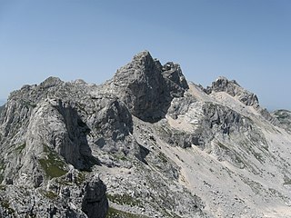
The Mittagskogel (German) or Kepa (Slovenian) has an elevation of 2,145 metres (7,037 ft) aA, and is thus the third highest mountain in the Karawanks range, after Hochstuhl/Stol and the Vertratscha/Vrtača. It is located on the border between Slovenia and Austria.

The Municipality of Črna na Koroškem is a municipality in northern Slovenia. The seat of the municipality is the town of Črna na Koroškem. It lies in the traditional Slovenian province of Carinthia, close to the border with Austria. Since 2005 it has been part of the larger Carinthia Statistical Region. It borders Austria.

The Municipality of Kranjska Gora is a municipality on the Sava Dolinka River in the Upper Carniola region of northwest Slovenia, close to the Austrian and Italian borders. The seat of the municipality is the town of Kranjska Gora. It borders Italy & Austria.
The Slovenian Mountain Hiking Trail, sometimes also called Transverzala, is a route from Maribor to Ankaran. It covers most of the Slovenian mountain areas including Pohorje, the Julian Alps, the Kamnik-Savinja Alps, the Karawanks, and the southwestern part of Slovenia. It is the oldest hiking track in Europe.

Mount Olševa is a ridge mountain in the eastern part of the Karawanks near the border with Austria. The mountain separates Carinthia from Styria. Its highest point, Govca, is 1,929 meters (6,329 ft) high. Other peaks along the 5-kilometer (3.1 mi) ridge are Obel kamen on the western side, and Smooth Peak and Pretty Peak on the eastern part. About 200 meters (660 ft) below Obel kamen lies Potok Cave, an archaeological site from the Stone Age. To the southwest of the mountain, at an altitude of 1,115 m (3,658 ft), there is a chalybeate (iron-rich) spring.

Begunjščica is a ridge mountain in the Karawanks. It rises from the western Smokuč mountain pasture to St. Anne on its eastern side. The mountain has three main peaks, the highest being Big Peak. The western Middle Peak lies a little lower, and the lowest is Begunje Mount Vrtača. Its southern slopes rise over the Draga Valley. The ascent of the mountain is relatively easy and possible throughout the year. In the winter and early spring conditions are favourable for ski touring.

