Tsagaan Agui

Last updated
Tsagaan Agui
White Cave
Tsagaan Agui
LocationGobi Desert of southwest-central Mongolia
Coordinates 44°42′43.3″N101°10′13.4″E / 44.712028°N 101.170389°E / 44.712028; 101.170389
Discovery1972

Tsagaan Agui (Mongolian: White Cave), located in the Gobi Desert of southwest-central Mongolia, is a stratified Paleolithic cave site with a calcium carbonate crystal-lined inner chamber. The cave has yielded abundant archaeological materials, some perhaps as old as ca. 700,000 years ago. The cave has been (and continues to be) used sporadically by Buddhists as a pilgrimage destination. The cave has been under the protection of the Mongolian government since 1988. [1] [2] [3] [4] [5] [6] [7]

Contents

Geographical location

Tsagaan Agui is located in Bayankhongor province (aimaq) in the southern foothills of the Gobi Altay Mountains at 44º 42´ 43.3” N, 101 º 10´13.4” E, about 40 km northeast of the Bayan Lig county (suum) administrative center, southwest of the Zuun Bogd Uul (Baga Bogd Uul) mountain range. [8] [9] [10] [11]

History

The cave was discovered by Mongolian archaeologists in 1972 and first investigated by the Joint Soviet-Mongolian Historical-Cultural Expedition in 1987. In 1988–1989, excavations were continued by a Soviet-Mongolian Stone Age research team led by A. P. Derevianko and D. Tseveendorj. Between 1995 and 2000, excavations were undertaken at Tsagaan Agui by the Mongolian-Russian-American Archaeological Expeditions (JMRAAE). [2] JMRAAE reinitiated excavations at Tsagaan Agui in 2021 with support from the Leakey Foundation and the University of Arizona's Je Tsongkhapa Endowment for Central and Inner Asian Archaeology.

Cave structure and stratigraphy

Tsagaan Agui consists of five parts: 1) the Entrance Terrace, 2) the Entrance Grotto, 3) the Main Chamber, 4) the Inner Chamber, 5) and the Lower Grotto. [2]

Based on multiple analyses of the cave deposits, sedimentation is thought to have occurred during four cycles:

  1. Strata 10–11 of the cave's entryway, Stratum 6 in the lower grotto, Strata 13–14 in the entry grotto, and Strata 12–13 in the main chamber. A wetter and warmer environment prevailed. In this sedimentation cycle, around 70–90 % of the pollen is associated with trees and shrubs. The remains of spruce and pine pollen were detected.
  2. Strata 6–11 in the Main Chamber and Stratum 5 in the Lower Grotto. A cooler and drier environment than previously prevailed. Investigations show that arboreal species such as pine, birch, and spruce predominated in this part of the sedimentation cycle. Pollen of elm, maple, oak, lime, fir, honeysuckle, and hornbeam was also discovered here. [2]
  3. Lower part of Stratum 4 along with Stratum 5 in the entryway zone and Strata 3–5 in the Main Chamber. A cooler climate in comparison with the previous period was reconstructed here. A steppe ecosystem was most noticeable despite the presence of a forest complex. Among the spore and pollen findings, herbaceous and shrubby species predominated. However, the pollen of Picea, Pinus, and Betula in smaller amounts were also detected. [2]
  4. Stratum 2 in the entryway, the Entrance Grotto, and the cave's Main Chamber. A drier environment than previously was reconstructed. The debris revealed in this part of the cave includes a mixture of gravel, limestone, and calcite crystals. [2]

Archaeological finds

The earliest cultural remains revealed in the cave are associated with the first period of sedimentation (Stratum 13 in the entrance grotto and Stratum 12–13 in the Main chamber). Bifacially worked tools, combination tools, flakes, and retouched remnants were recovered here. [2]

Different forms of cores and core preforms, core-like pieces, blade spalls, flakes and chips, only a few with retouched platforms, and just one faceted platform were recovered from the second sedimentation cycle. [2]

Levallois-like flake cores, core platforms, core-like pieces, part of a Levallois blade, and flakes were observed in the third cycle of sedimentation. [2]

Remains of tools associated with the fourth sedimentation cycle are quite different from artifacts of the previous cycles. Tools were prepared on high-quality lithic raw material and a core reduction strategy was mainly used for producing bladelets. Scrapers, end-scrapers, trimmed tools, as well as retouched blades, burin-like tools, and combination tools were also recovered from this horizon. [2]

Based on the analysis of artifacts from the lowermost horizons at Tsagaan Agui Cave, it is suggested that a Levallois-Acheulean like industry existed in Mongolia as early as 500-400 thousand years ago. According to Derevianko and Okladnikov, similar technologies appeared in Central Asia because of the in-migration of a population using bifacial technology to this region. It is also assumed that the bearers of Levallois-Acheulean tools emigrated from central Kazakhstan (Lake Balkhash region) to southern Mongolia. Tools prepared on Levallois-like cores belonged to the Late Middle Paleolithic (early Zyrian glacial) period. Blades were found in the cave belonging to the Early Upper Paleolithic period. These blades reveal that the first Initial Upper Paleolithic blade technologies were present in the Gobi by around 27–33,000 years ago (i.e., the last half of the Kargan interstadial). [2] [12]

Floral and faunal remains

Pollen of broad-leaved species such as elm, hornbeam, maple, and lime and grains of grasses including members of the Moraceae, Lonicera, and Juglans families were detected. Myrica and Ostrya seeds showed that they are no later than the Pleistocene. [2]

A relatively humid environment was reconstructed in the bottom of the sediment column, therefore animal remains were only recovered from the upper units, especially from Strata 1–5 in the Main Chamber. Mammals associated with open steppes and montane niches, including kulan, arğalı, Siberian goat and dzeren (all currently present in Mongolia) dominated the faunal assemblage. In addition, bones of rhinoceros, cave hyenas and Tibetan antelope (Pantholops or chiru) were discovered in the cave's Pleistocene horizons. [2]

See also

Related Research Articles

<span class="mw-page-title-main">Hammerstone</span> Prehistoric stone tool

In archaeology, a hammerstone is a hard cobble used to strike off lithic flakes from a lump of tool stone during the process of lithic reduction. The hammerstone is a rather universal stone tool which appeared early in most regions of the world including Europe, India and North America. This technology was of major importance to prehistoric cultures before the age of metalworking.

<span class="mw-page-title-main">Lithic flake</span> Portion of rock removed from an objective piece by percussion or pressure

In archaeology, a lithic flake is a "portion of rock removed from an objective piece by percussion or pressure," and may also be referred to as simply a flake, or collectively as debitage. The objective piece, or the rock being reduced by the removal of flakes, is known as a core. Once the proper tool stone has been selected, a percussor or pressure flaker is used to direct a sharp blow, or apply sufficient force, respectively, to the surface of the stone, often on the edge of the piece. The energy of this blow propagates through the material, often producing a Hertzian cone of force which causes the rock to fracture in a controllable fashion. Since cores are often struck on an edge with a suitable angle (<90°) for flake propagation, the result is that only a portion of the Hertzian cone is created. The process continues as the flintknapper detaches the desired number of flakes from the core, which is marked with the negative scars of these removals. The surface area of the core which received the blows necessary for detaching the flakes is referred to as the striking platform.

A stone tool is, in the most general sense, any tool made either partially or entirely out of stone. Although stone tool-dependent societies and cultures still exist today, most stone tools are associated with prehistoric cultures that have become extinct. Archaeologists often study such prehistoric societies, and refer to the study of stone tools as lithic analysis. Ethnoarchaeology has been a valuable research field in order to further the understanding and cultural implications of stone tool use and manufacture.

<span class="mw-page-title-main">Burin (lithic flake)</span> Stone age tool

In the field of lithic reduction, a burin is a type of handheld lithic flake with a chisel-like edge which prehistoric humans used for engraving or for carving wood or bone.

<span class="mw-page-title-main">Mousterian</span> European Middle Paleolithic culture

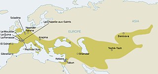
The Mousterian is an archaeological industry of stone tools, associated primarily with the Neanderthals in Europe, and to the earliest anatomically modern humans in North Africa and West Asia. The Mousterian largely defines the latter part of the Middle Paleolithic, the middle of the West Eurasian Old Stone Age. It lasted roughly from 160,000 to 40,000 BP. If its predecessor, known as Levallois or Levallois-Mousterian, is included, the range is extended to as early as c. 300,000–200,000 BP. The main following period is the Aurignacian of Homo sapiens.

<span class="mw-page-title-main">Bayankhongor Province</span> Province (aimag) of Mongolia

The Bayankhongor Province or Bayanhongor Aimag is one of the 21 aimags (provinces) of Mongolia. It is located in the southwest of the country and, at 116,000 square kilometers, it is one of the largest aimags. The capital of the aimag shares the provincial name, Bayankhongor.

<span class="mw-page-title-main">Levallois technique</span> Distinctive type of stone knapping technique used by ancient humans

The Levallois technique is a name given by archaeologists to a distinctive type of stone knapping developed around 250,000 to 300,000 years ago during the Middle Palaeolithic period. It is part of the Mousterian stone tool industry, and was used by the Neanderthals in Europe and by modern humans in other regions such as the Levant.

<span class="mw-page-title-main">Prepared-core technique</span> Means of producing stone tools

The prepared-core technique is a means of producing stone tools by first preparing common stone cores into shapes that lend themselves to knapping off flakes that closely resemble the desired tool and require only minor touch-ups to be usable.

Bayangovi is a sum (district) of Bayankhongor Province in south-eastern Mongolia. It is situated approximately 40 kilometres south of the lake Orog Nuur, 170 km from provincial capital Bayankhongor and 650 km south-west of Ulaanbaatar. Bayangovi is surrounded by the Ikhee Bogd mountain range, and by desert.

<span class="mw-page-title-main">Tabun Cave</span> Cave in northern Israel

The Tabun Cave is an excavated site located at Nahal Me'arot Nature Reserve, Israel and is one of the Human Evolution sites at Mount Carmel, which were proclaimed as having universal value by UNESCO in 2012.

<span class="mw-page-title-main">Late Stone Age</span> Period in African prehistory

The Later Stone Age (LSA) is a period in African prehistory that follows the Middle Stone Age.

Riwat is a Paleolithic site in Punjab, northern Pakistan. Another site, called Riwat Site 55, shows a later occupation dated to around 45,000 years ago.

<span class="mw-page-title-main">Kozarnika, Dimovo Municipality</span> Cave and archaeological site in Bulgaria

Kozarnika or Peshtera Kozarnika is a cave in northwestern Bulgaria that was used as a hunters’ shelter as early as the Lower Paleolithic. It marks an older route of early human migration from Africa to Europe via the Balkans, prior to the other currently suggested route - the one across Gibraltar. The cave probably keeps the earliest evidence of human symbolic behaviour and the earliest European Gravette flint assemblages came to light here.

John W. Olsen is an American archaeologist and paleoanthropologist specializing in the early Stone Age prehistory and Pleistocene paleoecology of eastern Eurasia. Olsen is Regents' Professor Emeritus of Anthropology and Executive Director of the Je Tsongkhapa Endowment for Central and Inner Asian Archaeology at the University of Arizona in Tucson, Arizona, USA. He is also a Leading Scientific Researcher at the Institute of Archaeology and Ethnography of the Russian Academy of Sciences' Siberian Branch in Novosibirsk and Guest Research Fellow at the Chinese Academy of Sciences' Institute of Vertebrate Paleontology and Paleoanthropology (IVPP) in Beijing where he is also Co-Director of the Zhoukoudian International Paleoanthropological Research Center. Olsen has been named a Distinguished Researcher of the Nihewan Research Center in Hebei Province, China. He is also a Foreign Expert affiliated with The Yak Museum in Lhasa, Tibet.

Minori Cave is part of the Callao limestone formation, located in Barangay Quibal, Municipality of Peñablanca, Cagayan Province in Northern Luzon. The said cave has two openings. One, designated as Mouth B, is located at 17° 43' 17" N latitude and 121° 49' 42" E longitude. The other opening, Mouth A is located 17° 43' 21" N latitude and 121° 49' 44" E longitude. The cave has an average elevation of about 200 m (656.2 ft) above sea level, and length and width of 147 m (482.3 ft) and 7 to 11 m, respectively. The cave is divided into four chambers with mouth A as chamber A and mouth B as chamber D. Chambers B and C are in between the two mouths.

The Obi-Rakhmat Grotto is a Middle Paleolithic prehistoric site that yielded Neanderthal fossils. It is a shallow karst cave near the junction of the Chatkal and Pskem Rivers at the southwestern end of the Talassky Alatau Range in the Tien Shan Mountains, 100 km (62 mi) northeast of Tashkent, Uzbekistan.

<span class="mw-page-title-main">Okladnikov Cave</span> Cave and archaeological site in Russia

Okladnikov Cave is a paleoanthropological site located in the foothills of the Altai Mountains in Soloneshensky District, Altai Krai in southern Siberia, Russia. The cave faces south and is located on a Devonian karst escarpment, lying about 14 metres (46 ft) above the left bank of the Sibiryachikha River valley below; the river itself is a tributary of the Anuy River.

The Ahmarian culture was a Paleolithic archeological industry in the Levant dated at 46,000–42,000 BP and thought to be related to Levantine Emiran and younger European Aurignacian cultures.

<span class="mw-page-title-main">Fumane Cave</span> Archaeological site in Italy

Fumane Cave is a dolomite cave in the Fumane Valley, which was formed in the Neogene period. The cave contains rich evidence of three prehistoric hominid cultures: Mousterian, Uluzzian and Aurignacian. Additionally, the cave has some of the oldest cave art that has been discovered in Europe.

<span class="mw-page-title-main">Tongtiandong</span> Archaeological site in the Xinjiang Autonomous Region of China

Tongtiandong is an archaeological site in the Xinjiang Autonomous Region of China, just to the south of the Altai mountains. The site had hunter-foraging human activity circa 40,000 BP.

References

  1. "Gobi Desert | Map, Plants, Animals, & Facts". Encyclopedia Britannica. Retrieved 2019-08-23.
  2. 1 2 3 4 5 6 7 8 9 10 11 12 13 Derevianko, A.P; W. Olsen, John; Krivoshapkin, A.I; Tseveendorj, D (2000). "The stratified cave site of Tsagaan Agui in the Gobi Altai (Mongolia)". Archaeology, Ethnology & Anthropology of Eurasia. 1 (1): 23–36.
  3. Blunden, Jane (2008). Mongolia. Bradt Travel Guides. pp. 312/420. ISBN   9781841621784.
  4. "WHITE CAVE". bayankhongor.khural.mn. Retrieved 2019-08-23.
  5. "Ikh Bogd Mountain | Gobi Desert| Magnificent Mongolia". Mongolian Tours Copy. Retrieved 2019-08-23.
  6. Baumer, Christoph (2012). The History of Central Asia: The Age of the Steppe Warriors. I.B.Tauris. pp. 23/372. ISBN   9781780760605.
  7. Deserts and Steppes. The Rosen Publishing Group. 2011. pp. 70/256. ISBN   9781615303175.
  8. Brantingham, P. Jeffrey; Kuhn, Steven L; Kerry, Kristopher W (2004). The Early Upper Paleolithic Beyond Western Europe. University of California Press. pp. 207–221. ISBN   9780520238510.
  9. Habu, Junko; V. Lape, Peter; W. Olsen, JohnOlsen (2017). Handbook of East and Southeast Asian Archaeology. Springer. pp. 68–69, 299–300. ISBN   9781493965212.
  10. "Tsagaan Cave | Mongolian Cave Research Association". www.mongoliancave.com. Retrieved 2019-08-23.
  11. O'Malley, Thomas; Skolnick, Adam Skolnick; Kohn, Michael; Karlin, Adam; Holden, Trent (2018). Lonely Planet Mongolia. Lonely Planet. ISBN   9781787019034.
  12. Shunkov, Michael (2005). "THE CHARACTERISTICS OF THE ALTAI (RUSSIA) MIDDLE PALEOLITHIC IN REGIONAL CONTEXT". Indo-Pacific Prehistory Association Bulletin. 25 (3): 69–77.

44°42′43.3″N101°10′13.4″E / 44.712028°N 101.170389°E / 44.712028; 101.170389