
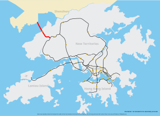
Tuen Mun District is one of the 18 administrative districts of Hong Kong. It is the westernmost continental district of Hong Kong. It had a population of 487,546 in 2011. Part of the district is the Tuen Mun New Town, which contains one of the largest residential areas in the New Territories.

Tuen Mun Road is a major expressway in Hong Kong which connects Tuen Mun with Tsuen Wan, within the New Territories. It is part of Hong Kong's Route 9, which circumnavigates the New Territories. Opened in 1978, it was once the major trunk route linking the northwest New Territories to urban Kowloon and is known for its frequent traffic jams and road accidents owing to its early design and heavy usage. As a result, speed limits have been enforced to 70–80 km/h (45–50 mph) due to geometric constraints.

Tuen Mun or Castle Peak is an area near the mouth of Tuen Mun River and Castle Peak Bay in the New Territories, Hong Kong. It was one of the earliest settlements in what is now Hong Kong and can be dated to the Neolithic period. In the more recent past, it was home to many Tanka fishermen who gathered at Castle Peak Bay. Tuen Mun is now a modern, mainly residential area in the north-west New Territories. As of 2011, 487,546 live in Tuen Mun and over 95% of them are Chinese.

Lam Tei is an area in the Tuen Mun District of the New Territories, Hong Kong. The region lies at the north end of Tuen Mun city. It is highly rural, with Miu Fat Buddhist Monastery being a landmark of the region.

Tuen Mun New Town, commonly referred to simply as Tuen Mun, is a satellite town of Hong Kong. It is one of the new towns that were developed by the Hong Kong Government in the New Territories from the 1960s. It was built around the existing rural local centre of Tuen Mun. The new town covers most of the urban area of Tuen Mun District.

Yuen Long Highway is a Hong Kong expressway connecting Au Tau in Yuen Long and Lam Tei in Tuen Mun of New Territories.
Route 10 is the newest trunk route in the Hong Kong Strategic Route and Exit Number System. It is a 10.9 km (6.8 mi) dual carriageway with three lanes in each direction, consisting of the Kong Sham Western Highway and the Shenzhen Bay Bridge of the Hong Kong–Shenzhen Western Corridor, connecting the Yuen Long Highway in Lam Tei to Shenzhen via border checkpoint Shenzhen Bay Port. The trunk route is the only one in Hong Kong that terminates at a border crossing.

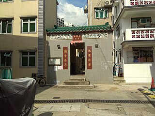
Tsing Chuen Wai is a walled village located in the Lam Tei area, in the northern part of Tuen Mun District, in Hong Kong.
The Tuen Mun Rural Committee is a rural committee in Hong Kong. It was founded by rural leader Chan Yat-sen in 1953 with representatives from 29 villages in Tuen Mun. Today the rural committee consisted of 36 villages and 69 village representatives.

Lam Tei Interchange is a major traffic interchange in Lam Tei, Tuen Mun District, New Territories, Hong Kong. It connects Castle Peak Road, Yuen Long Highway and Tsing Lun Road.

Tuen Tsz Wai is a village of Hong Kong, located in the Lam Tei area, in the northern part of Tuen Mun District. Part of the village is a historic Punti walled village.
San Hing Tsuen is a village in Lam Tei, Tuen Mun District, Hong Kong.

Lam Tei Tsuen is a walled village in Lam Tei, Tuen Mun District, Hong Kong.
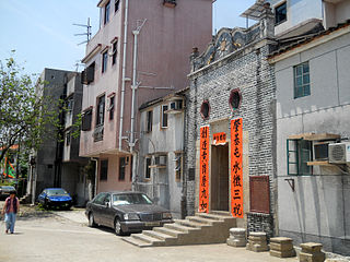
Nai Wai aka. Wong Kong Wai (黃崗圍) is a walled village in Lam Tei, Tuen Mun District, Hong Kong.
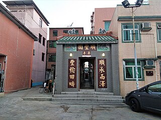
Sun Fung Wai, sometimes transliterated as Shun Fung Wai, is a walled village in Lam Tei, Tuen Mun District, Hong Kong.
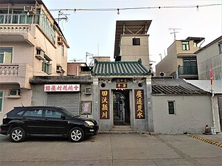
Chung Uk Tsuen aka. Kwong Tin Wai (廣田圍) is a walled village in Lam Tei, Tuen Mun District, Hong Kong.
Tuen Mun San Tsuen is a walled village in Lam Tei, Tuen Mun District, Hong Kong. The walled village is also called San Tsuen Wai (新村圍) or Tai Yuen Wai (大園圍).

To Yuen Wai is a village in Lam Tei, Tuen Mun District, Hong Kong.

Lam Tei Reservoir is a funnel-shaped reservoir located at the back hill of Lingnan University in Fu Tei, Tuen Mun, Hong Kong with an area of 17,000 m2 and a water storage capacity of 116,000 m3. It is located at the western edge of Tai Lam Country Park and less than one kilometre away from Hung Shui Hang Reservoir. Like Hung Shui Hang Reservoir, it is part of Tai Lam Chung Reservoir's further water supply plan and an irrigation reservoir. The water from the reservoir eventually flows through the Tuen Mun River and empties into the Castle Peak Bay. The reservoir can be accessed by Stage 2 of the Tuen Mun Trail.
This page is based on this
Wikipedia article Text is available under the
CC BY-SA 4.0 license; additional terms may apply.
Images, videos and audio are available under their respective licenses.
