
Alameda County is a county located in the U.S. state of California. As of the 2020 census, the population was 1,682,353, making it the 7th-most populous county in the state and 21st most populous nationally. The county seat is Oakland. Alameda County is in the San Francisco Bay Area, occupying much of the East Bay region.

The Tri-Valley area is grouping of three valleys in the East Bay region of California's Bay Area. The three valleys are Amador Valley, San Ramon Valley, and Livermore Valley. The Tri-Valley encompasses the cities of Dublin, Livermore, Pleasanton and San Ramon, the town of Danville and the CDPs of Alamo, Blackhawk and Diablo. The area is known for its Mediterranean climate, wineries, and nature. It is primarily suburban in character. The United States Census Bureau defines an urban area centered in the cities of Livermore, Pleasanton, and Dublin with a 2020 population of 240,381, ranked 167th in the United States in terms of population. The total population of the area is estimated to be 361,000. It offers more affordable living accommodations than the cities of San Francisco and San Jose.

Wheels is a public bus service in the Tri-Valley region (southeast Alameda County) of the San Francisco Bay Area in California, United States. It is operated by the Livermore Amador Valley Transit Authority (LAVTA). Wheels operates local and limited-stop service in Dublin, Pleasanton, and Livermore, with limited service into Contra Costa County along Interstate 680. The LAVTA was formed in 1985; service began in Dublin and Pleasanton in 1986. In 1987, it took over the 1978-opened Rideo service in Livermore. In 2023, the system had a ridership of 1,289,600, or about 4,700 per weekday as of the second quarter of 2024.
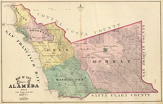
Murray Township was a township located in what is now the Livermore Valley portion of Alameda County, California, including the present day cities of Livermore, Dublin, and Pleasanton, and the census-designated place of Sunol.

Alameda Creek is a large perennial stream in the San Francisco Bay Area. The creek runs for 45 miles (72 km) from a lake northeast of Packard Ridge to the eastern shore of San Francisco Bay by way of Niles Canyon and a flood control channel. Along its course, Alameda Creek provides wildlife habitat, water supply, a conduit for flood waters, opportunities for recreation, and a host of aesthetic and environmental values. The creek and three major reservoirs in the watershed are used as water supply by the San Francisco Public Utilities Commission, Alameda County Water District and Zone 7 Water Agency. Within the watershed can be found some of the highest peaks and tallest waterfall in the East Bay, over a dozen regional parks, and notable natural landmarks such as the cascades at Little Yosemite and the wildflower-strewn grasslands and oak savannahs of the Sunol Regional Wilderness.

San Leandro Creek is a 21.7-mile-long (34.9 km) year-round natural stream in the hills above Oakland in Alameda County and Contra Costa County of the East Bay in northern California.

San Mateo Creek is a perennial stream whose watershed includes Crystal Springs Reservoir, for which it is the only natural outlet after passing Crystal Springs Dam.

Arroyo Mocho is a 34.7-mile-long (55.8 km) stream which originates in the far northeastern corner of Santa Clara County and flows northwesterly into eastern Alameda County, California. After traversing the cities of Livermore and Pleasanton it joins South San Ramon Creek to become Arroyo de la Laguna, which in turn flows to Alameda Creek and thence to San Francisco Bay.

Arroyo de la Laguna is a 7.5-mile-long (12.1 km) southward-flowing stream in Alameda County, California, United States which originates at the confluences of South San Ramon Creek and Arroyo Mocho. The Arroyo de la Laguna is fed by tributaries in the Amador Valley and certain eastern slope drainages of the Diablo Range; these tributaries include Arroyo Valle and Sinbad Creek. Arroyo del la Laguna is the major tributary to Alameda Creek which in turn flows into the San Francisco Bay.
The Tassajara Formation is a geologic unit within the Livermore Valley of Northern California, United States. The formation surfaces only in the northern upland parts of the Livermore Valley and underlie the central part of the valley floor at a depth ranging from 250 feet (80 m) to 700 feet (200 m). The Tassajara Formation consists of sediments ranging from brown to gray mudstone, andesitic sandstone, conglomerate, and minor bentonitic and pumiceous tuff. In the northern San Ramon area, the Tassajara Formation underlies Quaternary valley fill material.
Sausal Creek, 3.1 miles (5.0 km) long, is one of the principal creeks in Oakland, California.
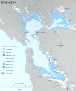
The Hydrography of the San Francisco Bay Area is a complex network of watersheds, marshes, rivers, creeks, reservoirs, and bays predominantly draining into the San Francisco Bay and Pacific Ocean.
Upper Penitencia Creek is actually one of two creeks by the name Penitencia Creek in the northeastern Santa Clara Valley of Santa Clara County, California. They are both tributaries of Coyote Creek. The upper creek was diverted southwestward, connecting it directly to Coyote Creek ca. 1850 by a farmer to irrigate his fields, permanently splitting Upper Penitencia Creek from Lower Penitencia Creek. Upper Penitencia Creek drains the western slopes of Mount Hamilton of the Diablo Range, and passes through Alum Rock Park, before ending at its confluence with Coyote Creek at Berryessa Road. In December 2018, the San Francisco Estuary Institute published a report commissioned by the Santa Clara Valley Water District to establish a vision for Upper Penitencia Creek's lower four miles focusing on ways "to expand flow conveyance and flood water storage from the Coyote Creek confluence upstream to the Dorel Drive bridge in a manner that works with the existing landscape features and supports habitats for native species".
Amador Valley is a valley in eastern Alameda County, California and is the location of the cities of Dublin and Pleasanton. Part of Tri-Valley, the valley is bounded by the foothills of the Diablo Range on the north and south, Pleasanton Ridge to the west, and Livermore Valley to the east.
El Camino Viejo a Los Ángeles, also known as El Camino Viejo and the Old Los Angeles Trail, was the oldest north-south trail in the interior of Spanish colonial Las Californias (1769–1822) and Mexican Alta California (1822–1848), present day California. It became a well established inland route, and an alternative to the coastal El Camino Real trail used since the 1770s in the period.
Sausal Creek is a 3.0-mile-long (4.8 km) northwesterly-flowing stream originating in Portola Valley along the northeastern edge of the Windy Hill Open Space Preserve in the eastern foothills of the Santa Cruz Mountains, in San Mateo County, California, United States. After being joined by Alambique Creek it flows through Middle Searsville Marsh/Pond before ending at its confluence with Corte Madera Creek in a natural marsh above Searsville Reservoir on Stanford University lands. Below Searsville Reservoir and Dam, Corte Madera Creek joins with Bear Creek to form San Francisquito Creek and flows to San Francisco Bay.

Arroyo Valle or Arroyo Del Valle is a 36.4-mile-long (58.6 km) westward-flowing stream that begins in northeastern Santa Clara County, California, and flows northwesterly into Alameda County where it is dammed to form Lake Del Valle. After that Arroyo Valle is a tributary to Arroyo de la Laguna which in turn flows into Alameda Creek and thence to San Francisco Bay. In the past, the Arroyo Valle had a significant steelhead migration; however, degradation of the stream in the latter half of the 20th century has decimated this anadromous fish population.
Arroyo Bayo is an 8-mile-long (13 km) perennial stream which flows northwest along Mount Hamilton Road east of Mt. Hamilton in the Diablo Range. It is part of the southern Alameda Creek watershed in Santa Clara County, California.

The Laguna Creek watershed consists of 25.1 square miles (100 km2) of land within northern California's Alameda County. The watershed drains the foothills of the Diablo Range south of Niles Canyon. To the southeast, the area of Mission Peak Regional Preserve around Mission Peak is included. Agua Caliente, Canada del Aliso, Mission, Morrison, Sabercat, Vargas, and Washington creeks drain the area of the watershed. They drain into Laguna Creek and eventually Mud Slough.
Lower Silver Creek is a 4.7-mile-long (7.6 km) northwest and westward-flowing stream currently originating just north of Lake Cunningham in Evergreen Valley in southeast San Jose, Santa Clara County, California. It is tributary to Coyote Creek, whose waters flow to south San Francisco Bay and the Pacific Ocean.

