History
The Yima, a group comprising both Northern Pomo and Eastern Pomo, used to live in the area containing Scotts Valley, Blue Lakes, Tule Lake and extended to Clear Lake. They used to camp along the lakeshore during the root-digging season.
Tule Lake has deep alluvial soils and silty clay loam, suitable for field crops. In 1891 European settlers began growing and canning string beans near Tule Lake. Henry Wambold, who built the Laurel Dell Hotel, built a string bean cannery in 1891. In 1899 production of string beans was increased, and efforts began to drain parts of Tule Lake for farm use. Wambold "reclaimed the land known as Tule Lake, by draining the land, turning the soil, raking the tule roots from the soil and hauling them away." The cannery was later operated by the Lake County Canning Company. In 1944 and 1950 the green beans, mainly grown in the Tule Lake reclamation area, were an important crop in the region.
Tule Lake continues to be used in summer for growing wild rice and grazing cattle. In winter the lake is used as a wintering area by bald eagles, and as a stopover for waterfowl and water birds. There have been proposals by the California Department of Fish and Game (DFG) and (United States Army Corps of Engineers (USACE) to restore wetlands of Tule Lake and the adjacent Rodman Slough Reclamation Area.
Lake County is a county located in the north central portion of the U.S. state of California. As of the 2020 census, the population was 68,163. The county seat is Lakeport. The county takes its name from Clear Lake, the dominant geographic feature in the county and the largest non-extinct natural lake wholly within California.

Upper Lake is a census-designated place (CDP) in Lake County, California, United States. Upper Lake is located 8 miles (13 km) north of Lakeport, at an elevation of 1,345 feet (410 m). The population was 1,052 at the 2010 census, up from 989 at the 2000 census. The Habematolel Pomo of Upper Lake are headquartered here.
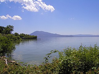
Clear Lake is a natural freshwater lake in Lake County in the U.S. state of California, north of Napa County and San Francisco. It is the largest natural freshwater lake wholly within the state, with 68 square miles (180 km2) of surface area. At an age of 0.5 million years, it is the oldest lake in North America. It is the latest lake to occupy a site with a history of lakes stretching back at least 2,500,000 years.

The Kings River, is a 132.9-mile (213.9 km) river draining the Sierra Nevada mountain range in central California in the United States. Its headwaters originate along the Sierra Crest in and around Kings Canyon National Park and form the eponymous Kings Canyon, one of the deepest river gorges in North America. The river is impounded in Pine Flat Lake before flowing into the San Joaquin Valley southeast of Fresno. With its upper and middle course in Fresno County, the Kings River diverges into multiple branches in Kings County, with some water flowing south to the old Tulare Lake bed and the rest flowing north to the San Joaquin River. However, most of the water is consumed for irrigation well upstream of either point.

The Kern River, previously Rio de San Felipe, later La Porciuncula, is an Endangered, Wild and Scenic river in the U.S. state of California, approximately 165 miles (270 km) long. It drains an area of the southern Sierra Nevada mountains northeast of Bakersfield. Fed by snowmelt near Mount Whitney, the river passes through scenic canyons in the mountains and is a popular destination for whitewater rafting and kayaking. It is the southernmost major river system in the Sierra Nevada, and is the only major river in the Sierra that drains in a southerly direction.

Lost River begins and ends in a closed basin in northern California and southern Oregon in the United States. The river, 60 miles (97 km) long, flows in an arc from Clear Lake Reservoir in Modoc County, California, through Klamath County, Oregon, to Tule Lake in Siskiyou County, California. About 46 mi (74 km) of Lost River are in Oregon, and 14 miles (23 km) are in California.

Schoenoplectus acutus, called tule, common tule, hardstem tule, tule rush, hardstem bulrush, or viscid bulrush, is a giant species of sedge in the plant family Cyperaceae, native to freshwater marshes all over North America. The common name derives from the Nāhuatl word tōllin, and it was first applied by the early settlers from New Spain who recognized the marsh plants in the Central Valley of California as similar to those in the marshes around Mexico City.

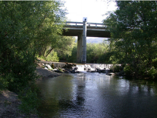
Cache Creek is an 87-mile-long (140 km) stream in Lake, Colusa and Yolo counties, California.

The Lost River sucker is a species of ray-finned fish in the family Catostomidae. It is the only living member of the genus Deltistes. It is found only in California and Oregon. Its population is much reduced from historical numbers for a number of reasons. It is federally listed as an endangered species of the United States. This species is known as the C'waam by the Klamath Tribes, a Native American nation.

East Fork Russian River is a 15 mi (24 km) long tributary of the Russian River in Mendocino County, California artificially connected to the Eel River via an interbasin diversion at the Potter Valley Project hydroelectric facility. It forms in the north of Potter Valley, flows south through this valley, then southwest through a mountain pass to Lake Mendocino, an artificial reservoir that empties into Russian River. At one time Clear Lake to the east drained through Cold Creek then along the lower part of East Fork Russian River through Coyote Valley to the Russian River proper. A few hundred years ago a massive landslide blocked this channel, and Clear Lake found a new outlet to the Sacramento River.

Kelsey Creek is a watercourse in Lake County, California, United States, that feeds Clear Lake from the south. The watershed was forest-covered. In the lower parts it has been converted to farmland and for urban use. Higher up the forests have been cleared, regrown and cleared again. The northern part of the creek flows through a geothermal field that feeds power plants and hot springs. The wooded Cobb area in the higher part of the watershed holds resorts and resort communities, some dating to the 1850s.

Cow Mountain is a ridge in the Mayacamas Mountains in Lake County, California, and Mendocino County, California. It is home to two large recreation areas. One is closed to off-road vehicles and the other is not. Erosion from the mountain, caused in part by human land use, contributes sediment and nutrients to Clear Lake.
Cow Mountain Ridge is a ridge in Lake County, California, and Mendocino County, California. It joins Cow Mountain from the south.

Scotts Creek is a stream in Lake County, California, the largest tributary of Clear Lake. It rises to the south of Cow Mountain in the Mayacamas Mountains, then flows southeast towards Clear Lake, running through the fertile Scotts Valley and the seasonal Tule Lake before joining Middle Creek and flowing into the lake via Rodman Slough.

Cold Creek is a river of Mendocino County, California, a tributary of East Fork Russian River. In the past it may have connected Clear Lake to the Russian River before this route was blocked by a large landslide and Clear Lake began to drain into the Sacramento River watershed.

The Blue Lakes are a string of two or three lakes in Lake County, California, set in a deep canyon. At one time they seem to have been in the Russian River watershed, but a recent geological upheaval cut them off from that basin and they now drain via Scotts Creek into Clear Lake in the Sacramento River basin. In the 19th and early 20th centuries there were several resorts around the lakes. Their waters have been highly altered by human activity and most of their native fish are lost, but they have a healthy population of largemouth bass.

Rodman Slough is a wetland that drains into Clear Lake in Lake County, California. It provides an important habitat for fish, amphibians, birds and other wildlife. It is fed by Scotts Creek and Middle Creek, which contribute about 70% of the sediment and nutrients that cause algae problems in Clear Lake. The slough is the remnant of a much larger area of wetlands and open water that extended from Tule Lake to the northeast through a wide area of land north and east of the present slough that was drained for farmland. Since 1978 there have been proposals to restore large parts of the former wetlands, and much of the funding has been approved, but progress has been slow.
Middle Creek is a creek that drains through Rodman Slough into Clear Lake in Lake County, California. It supplies 21% of the streamflow to Clear Lake. The watershed vegetation has been drastically modified by European settlers through sheep and cattle grazing, logging and farming in the valley floors. The creek once flowed through extensive wetlands at its mouth, but these were mainly drained to create farmland, apart from Rodman Slough on the west side. There are now projects to restore the drained land to its original condition.

Rivers and creeks in Lake County, California are listed below by river basin and alphabetically. Unless otherwise stated, the information is taken from the Geographic Names Information System maintained by the United States Geological Survey. Coordinates, elevations and lengths from this source are approximate.


