History
In the past the Scotts and Middle creeks flowed through Robinson Lake, also called Rodman Bay, before entering Clear Lake. Robinson Lake was a mosaic of shallow wetlands, meandering channels, riparian forest and open water. Bloody island was historically an upland island in Robinson Lake surrounded by a complex of seasonal and perennial wetland. The island was the site of the 1850 Bloody Island Massacre in response to a Pomo revolt from slavery.
Between 1918 and 1933 farmers built levees in Robinson Lake and the area was drained for agriculture, leaving only the narrow Rodman Slough along the west of the former lake. The heavy earth-moving equipment used to "reclaim" about 2,000 acres (810 ha) of wetland was one of the causes of a surge in sedimentation in Clear Lake after 1927.
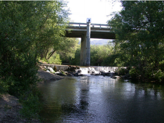
In 1955 Congressman Hubert B. Scudder introduced a bill, which was authorized, for flood control works on Middle Creek at an estimated Federal cost of $1,110,000 and Non-Federal Cost of $790,000. At this time the community of Upper Lake was partially flooded three times a year, and almost all the town was flooded every ten years. In 1966 the United States Army Corps of Engineers (USACE) completed levees on the north side of Scotts Creek between Tule Lake and the mouth of Rodman Slough as part of the Middle Creek Flood Control project. The levees were intended to reduce the risk of flooding urban communities and agricultural areas.
In 1978 the Federal Emergency Management Agency (FEMA) determined that much of the area covered by the flood control project was in the 100-year floodplain of Clear Lake. Restoring the area to its natural state would reduce costs of maintaining old levees and drainage pumps, and reduce or eliminate the cost of fighting floods in high water years.
The levees are substandard and have settled, and are as little as 10.5 feet (3.2 m) above the lowest normal Clear Lake water level. In the past (1890) the Clear Lake water level has risen to 13.66 feet (4.16 m) above this lowest level. There is a very real risk that the levees will be submerged by the type of flood expected at least once every century. The Robinson Lake area was evacuated due to flood threats in 1983, 1986 and 1998. In 1995 Scotts Creek overtopped the levee, flooding parts of Highway 20.
In 2004 the Fish and Game Commission designated the Clear Lake Wildlife Area, a 97 acres (39 ha) wildlife area extending to the east of the slough in which visitors could engage in birdwatching, seasonal fishing, wildlife viewing and hunting. It included oak-covered hills, dense tule marsh and an extensive riparian habitat. It supports herons, red-tailed hawks, osprey, songbirds, waterfowl, deer, gray fox, bobcat, and coyote.
Restoration projects
Proposals were made by the California Department of Fish and Game (DFG; now the California Department of Fish and Wildlife) and United States Army Corps of Engineers to restore wetlands of Tule Lake and the adjacent Rodman Slough Reclamation Area.
The Middle Creek Restoration Project plans to remove 3 miles (4.8 km) of substandard levees. This will restore 1,400 acres (570 ha) of wetlands and open water, and will improve water quality in Clear Lake. In 2004 the Lake County water district signed a contract with the USACE to breach some of the levees and restore the former Robinson Lake. The Army Corps would cover 65% of the costs, but the water district had to compensate over 60 private property owners, raise a section of California State Route 20, reinforce seven PG&E power line pylons and replace a bridge on the Nice-Lucerne Cutoff. The water district moved slowly, and took 14 years to spend $12 million of funding that had been supplied by the state.
In 2008 the DFG issued a draft Conceptual Area Protection Plan for the Clear Lake Wildlife Area. The expanded wildlife area would now cover about 3,225 acres (1,305 ha) including a large part of Tule Lake, the Middle Creek Restoration Project, additional land to the south of this project, and DFG lands and Land Trust lands south of Rodman Slough. Over half the area would be wetland habitat, with the remainder being riparian, open water and oak woodland. The area would conserve and create natural habitat in one of the few relatively natural areas around Clear Lake. It may be valuable to sensitive species such as the Western pond turtle (Actinemys marmorata), foothill yellow-legged frog (Rana boylii), California red-legged frog (Rana draytonii), tricolored blackbird (Agelaius tricolor), double-crested cormorant (Phalacrocorax auritus), osprey (Pandion haliaetus) and bald eagle (Haliaeetus leucocephalus).
In June 2019 the Lake County Watershed Protection District accepted $15 million from the California Department of Water Resources to purchase and maintain properties affected by the ongoing Middle Creek Flood Damage Reduction and Ecosystem Restoration Project. The project would remove failing levees and restore water coverage to about 1,600 acres (650 ha) of reclaimed farmland. It would provide an area to the north, well away from the lake, where the water would slow down and drop its sediment. It would avert a breach further south, which would release far more sediment and nutrients into the lake. The state's total contribution would be almost $28 million.
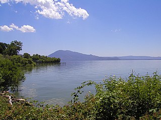
Clear Lake is a natural freshwater lake in Lake County in the U.S. state of California, north of Napa County and San Francisco. It is the largest natural freshwater lake wholly within the state, with 68 square miles (180 km2) of surface area. At an age of 0.5 million years, it is the oldest lake in North America. It is the latest lake to occupy a site with a history of lakes stretching back at least 2,500,000 years.

The Guadalupe River mainstem is an urban, northward flowing 14 miles (23 km) river in California whose much longer headwater creeks originate in the Santa Cruz Mountains. The river mainstem now begins on the Santa Clara Valley floor when Los Alamitos Creek exits Lake Almaden and joins Guadalupe Creek just downstream of Coleman Road in San Jose, California. From here it flows north through San Jose, where it receives Los Gatos Creek, a major tributary. The Guadalupe River serves as the eastern boundary of the City of Santa Clara and the western boundary of Alviso, and after coursing through San José, it empties into south San Francisco Bay at the Alviso Slough.

The Sacramento–San Joaquin River Delta, or California Delta, is an expansive inland river delta and estuary in Northern California. The Delta is formed at the western edge of the Central Valley by the confluence of the Sacramento and San Joaquin rivers and lies just east of where the rivers enter Suisun Bay, which flows into San Francisco Bay, then the Pacific Ocean via San Pablo Bay. The Delta is recognized for protection by the California Bays and Estuaries Policy. Sacramento–San Joaquin Delta was designated a National Heritage Area on March 12, 2019. The city of Stockton is located on the San Joaquin River at the eastern edge of the delta. The total area of the Delta, including both land and water, is about 1,100 square miles (2,800 km2). Its population is around 500,000.

The Yolo Bypass is one of the two flood bypasses in California's Sacramento Valley located in Yolo and Solano Counties. Through a system of weirs, the bypass diverts floodwaters from the Sacramento River away from the state's capital city of Sacramento and other nearby riverside communities.
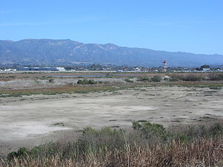
The Goleta Slough is an area of estuary, tidal creeks, tidal marsh, and wetlands near Goleta, California, United States. It primarily consists of the filled and unfilled remnants of the historic inner Goleta Bay about 8 miles (13 km) west of Santa Barbara. The slough empties into the Pacific Ocean through an intermittently closed mouth at Goleta Beach County Park just east of the UCSB campus and Isla Vista. The slough drains the Goleta Valley and watershed, and receives the water of all of the major creeks in the Goleta area including the southern face of the Santa Ynez Mountains.

The Klamath Project is a water-management project developed by the United States Bureau of Reclamation to supply farmers with irrigation water and farmland in the Klamath Basin. The project also supplies water to the Tule Lake National Wildlife Refuge, and the Lower Klamath National Wildlife Refuge. The project was one of the first to be developed by the Reclamation Service, which later became the Bureau of Reclamation.

Located in northern California, the Suisun Marsh has been referred to as the largest brackish water marsh on west coast of the United States of America. The marsh land is part of a tidal estuary, and subject to tidal ebb and flood. The marsh is home to many species of birds and other wildlife, and is formed by the confluence of the Sacramento and San Joaquin rivers between Martinez and Suisun City, California and several other smaller, local watersheds. Adjacent to Suisun Bay, the marsh is immediately west of the legally defined Sacramento-San Joaquin Delta as well as part of the San Francisco Bay estuary.

The Pajaro River is a U.S. river in the Central Coast region of California, forming part of the border between San Benito and Santa Clara Counties, the entire border between San Benito and Santa Cruz County, and the entire border between Santa Cruz and Monterey County. Flowing roughly east to west, the river empties into Monterey Bay, west of Watsonville, California.

Elkhorn Slough is a 7-mile-long (11 km) tidal slough and estuary on Monterey Bay in Monterey County, California. It is California's second largest estuary and the United States' first estuarine sanctuary. The community of Moss Landing and the Moss Landing Power Plant are located at the mouth of the slough on the bay.
Pescadero Creek is a major stream in Santa Cruz and San Mateo counties in California, United States. At 26.6 miles (42.8 km), it is the longest stream in San Mateo County and flows all year from springs in the Santa Cruz Mountains. Its source is at 1,880 feet (570 m) above sea level on the western edge of Castle Rock State Park, with additional headwaters in Portola Redwoods State Park, and its course traverses Pescadero Creek County Park and San Mateo County Memorial Park before entering Pescadero Marsh Natural Preserve at Pescadero State Beach and thence to the Pacific Ocean 14.4 miles (23 km) south of Half Moon Bay.

The Yolo Bypass Wildlife Area, located within the Yolo Bypass in Yolo County, California, is managed by the California Department of Fish and Wildlife with the intent of restoring and managing a variety of wildlife habitats in the Yolo Basin, a natural basin in the north part of the Sacramento-San Joaquin River Delta. The creation of the wildlife area was spearheaded by the Yolo Basin Foundation. The California Department of Fish and Wildlife and Yolo Basin Foundation are the core partners in the operation of this resource located at 38.550515°N 121.626291°W

East Fork Russian River is a 15 mi (24 km) long tributary of the Russian River in Mendocino County, California artificially connected to the Eel River via an interbasin diversion at the Potter Valley Project hydroelectric facility. It forms in the north of Potter Valley, flows south through this valley, then southwest through a mountain pass to Lake Mendocino, an artificial reservoir that empties into Russian River. At one time Clear Lake to the east drained through Cold Creek then along the lower part of East Fork Russian River through Coyote Valley to the Russian River proper. A few hundred years ago a massive landslide blocked this channel, and Clear Lake found a new outlet to the Sacramento River.

The Columbia Slough is a narrow waterway, about 19 miles (31 km) long, in the floodplain of the Columbia River in the U.S. state of Oregon. From its source in the Portland suburb of Fairview, the Columbia Slough meanders west through Gresham and Portland to the Willamette River, about 1 mile (1.6 km) from the Willamette's confluence with the Columbia. It is a remnant of the historic wetlands between the mouths of the Sandy River to the east and the Willamette River to the west. Levees surround much of the main slough as well as many side sloughs, detached sloughs, and nearby lakes. Drainage district employees control water flows with pumps and floodgates. Tidal fluctuations cause reverse flow on the lower slough.

The Cosumnes River Preserve is a nature preserve of over 51,000 acres (210 km2) located 20 miles (30 km) south of Sacramento, in the US state of California. The preserve protects a Central Valley remnant that once contained one of the largest expanses of oak tree savanna, riparian oak forest and wetland habitat in North America. Agricultural development has changed the landscape from groves of oaks and tule marshes to productive farmlands.

Greco Island is a wetland island in Redwood City, California. Greco Island is part of the larger Don Edwards San Francisco Bay National Wildlife Refuge. Westpoint Slough follows the South side of the island while Redwood Creek is along the West. The San Francisco Bay bounds the North and East sides of the island.

Scotts Creek is a stream in Lake County, California, the largest tributary of Clear Lake. It rises to the south of Cow Mountain in the Mayacamas Mountains, then flows southeast towards Clear Lake, running through the fertile Scotts Valley and the seasonal Tule Lake before joining Middle Creek and flowing into the lake via Rodman Slough.

Cold Creek is a river of Mendocino County, California, a tributary of East Fork Russian River. In the past it may have connected Clear Lake to the Russian River before this route was blocked by a large landslide and Clear Lake began to drain into the Sacramento River watershed.

The Blue Lakes are a string of two or three lakes in Lake County, California, set in a deep canyon. At one time they seem to have been in the Russian River watershed, but a recent geological upheaval cut them off from that basin and they now drain via Scotts Creek into Clear Lake in the Sacramento River basin. In the 19th and early 20th centuries there were several resorts around the lakes. Their waters have been highly altered by human activity and most of their native fish are lost, but they have a healthy population of largemouth bass.
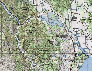
Tule Lake is a seasonal lake in Lake County, California. It is named after the edible bullrushes, or tules, that used to surround the lake. These have been cleared and the lake partly drained to support agriculture, but it still floods every winter. In summer it is used for growing wild rice and grazing cattle. There have been proposals to restore the lake to its original wetlands condition.
Middle Creek is a creek that drains through Rodman Slough into Clear Lake in Lake County, California. It supplies 21% of the streamflow to Clear Lake. The watershed vegetation has been drastically modified by European settlers through sheep and cattle grazing, logging and farming in the valley floors. The creek once flowed through extensive wetlands at its mouth, but these were mainly drained to create farmland, apart from Rodman Slough on the west side. There are now projects to restore the drained land to its original condition.


