Tull en 't Waal

Last updated
Tull en 't Waal
Village
Waalseweg-3 Tull-en-'t Waal Nederland.JPG
School in Tull en 't Waal
P06-UT-positiekaart2-gemlabels.png
Red pog.svg
Tull en 't Waal
Location in the Netherlands
Netherlands location map.svg
Red pog.svg
Tull en 't Waal
Tull en 't Waal (Netherlands)
Coordinates: 52°0′2″N5°7′59″E / 52.00056°N 5.13306°E / 52.00056; 5.13306 Coordinates: 52°0′2″N5°7′59″E / 52.00056°N 5.13306°E / 52.00056; 5.13306
Country Netherlands
Province Utrecht
Municipality Houten
Area
[1]
  Total6.23 km2 (2.41 sq mi)
Elevation
[2]
2 m (7 ft)
Population
 (2021) [1]
  Total760
  Density120/km2 (320/sq mi)
Time zone UTC+1 (CET)
  Summer (DST) UTC+2 (CEST)
Postal code
3999 [1]
Dialing code 030

Tull en 't Waal is a village in the Dutch province of Utrecht. Until 1962, it was a separate municipality, but now it is a part of the municipality of Houten. Originally, there were two villages: 't Waal, at the site of the present village; and Tull, more to the south. It also has a ferry connection to the town of Culemborg. [3] It is located close to the Lek River. [4]

Contents

History

Tull is first mentioned in 1155 as "in loco qui dicitur Tylle". The etymology is unclear. [5] 't Waal was first mentioned in 1307 as Wale, and means "pool after a dike breach". In 1504, the hamlets are first mentioned as Tul ende tWael. [6] The village is a 12th century peat excavation project along the Waalsewetering. The church is a medieval building which was extensively modified in 1778 and 1890. [7] The hamlet Honswijk  [ nl ] used to be part of the village, but was transferred to Schalkwijk. In 1840, Tull en 't Waal was home to 532 people. [4]

Werk aan de Waalse Wetering is a military fortification as part of the Dutch Water Line. It was constructed in 1815, and has bomb proof barracks. [8] The fort became obsolete after the investion of the air plane. It was later used by the Nederlandse Spoorwegen to store bridging material. In 1999, it was converted into a tea house and camping. [4]

Related Research Articles

Wetering Hamlet in Overijssel, Netherlands

Wetering is a hamlet in the Dutch province of Overijssel. It is located in the municipality of Steenwijkerland, about 9 km southwest of the town of Steenwijk.

Pannerden Village in Gelderland, Netherlands

Pannerden is a village in the Dutch province of Gelderland. It is located in the municipality of Zevenaar.

Benschop, Utrecht Village in Utrecht, Netherlands

Benschop is a village in the Dutch province of Utrecht. It is a part of the municipality of Lopik, and lies about 4 km west of IJsselstein. Benschop is an extremely long village: apart from a relatively compact town centre, it consists of a long ribbon of houses on both sides of the Benschopsche Wetering. Until 1989, Benschop was a separate municipality.

Jaarsveld Village in Utrecht, Netherlands

Jaarsveld is a village in the Dutch province of Utrecht. It is a part of the municipality of Lopik, and lies about 7 km southwest of IJsselstein.

Uitweg Hamlet in Utrecht, Netherlands

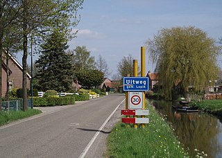
Uitweg is a hamlet in the Dutch province of Utrecht. It is a part of the municipality of Lopik, and lies about 5 km southwest of IJsselstein. The town consists almost completely of a ribbon of farms along the Enge IJssel and Lopiker Wetering rivers, between Graaf and Lopikerkapel.

Amstelhoek Village in Utrecht, Netherlands

Amstelhoek is a village in the Dutch province of Utrecht. It is in the municipality of De Ronde Venen, about 3 km (1.9 mi) northwest of Mijdrecht. Amstelhoek lies on the river Amstel, directly across from Uithoorn.

Schalkwijk, Utrecht Village in Utrecht, Netherlands

Schalkwijk [ˈsxɑɫkʋɛik] is a small village in the Dutch province of Utrecht. It consists of a small village centre on the railway line between Utrecht and 's-Hertogenbosch and a 5 km long ribbon of farms along the small channel Schalkwijksche Wetering.

Oud-Wulven Hamlet in Utrecht, Netherlands

Oud-Wulven is a hamlet in the Dutch province of Utrecht. It is located just north of the village of Houten, and is part of that municipality.

Heemstede, Utrecht Hamlet in Utrecht, Netherlands

Heemstede is a hamlet in the central Netherlands. It is located 3 km west of Houten, Utrecht. The hamlet is known for Heemstede Castle (1645).

Achthoven, Vijfheerenlanden Hamlet in Utrecht, Netherlands

Achthoven is a hamlet in the Dutch province of Utrecht. It is a part of the municipality of Vijfheerenlanden, and lies about 7 km south of IJsselstein.

Tienhoven aan de Lek Village in Utrecht, Netherlands

Tienhoven is a village in the Dutch province of Utrecht. It is a part of the municipality of Vijfheerenlanden, and lies about 10 km southwest of IJsselstein.

Blauwkapel Hamlet in Utrecht, Netherlands

Blauwkapel is a hamlet in the Dutch province of Utrecht. It is about 1 km north-east of the city of Utrecht. It is mainly in the municipality of de Bilt, but a small part is in the city of Utrecht.

Nieuwe-Wetering Hamlet in Utrecht, Netherlands

Nieuwe-Wetering is a hamlet in the Dutch province of Utrecht. It is a part of the municipality of De Bilt, and lies about 3 km northwest of Bilthoven.

Herwijnen Village in Gelderland, Netherlands

Herwijnen is a village in the Dutch province of Gelderland. It is a part of the municipality of West Betuwe, and lies about 11 km east of Gorinchem.

Nieuwaal Village in Gelderland, Netherlands

Nieuwaal is a village in the Dutch province of Gelderland. It is a part of the municipality of Zaltbommel, and lies about 14 km east of Gorinchem.

Altforst Village in Gelderland, Netherlands

Altforst is a village in the Dutch province of Gelderland. It is a part of the municipality of West Maas en Waal, and lies about 10 km north of Oss.

Beneden-Leeuwen Town in Gelderland, Netherlands

Beneden-Leeuwen is a town in the Dutch province of Gelderland. It is a part of the municipality of West Maas en Waal, and lies about 7 km east of Tiel, on the opposite (southern) bank of the river Waal. Beneden-Leeuwen has 6,925 inhabitants on 1 July 2021. It is the Catholic part of the former village Leeuwen.

Boven-Leeuwen Village in Gelderland, Netherlands

Boven-Leeuwen is a village in the Dutch province of Gelderland. It is a part of the municipality of West Maas en Waal, and lies about 9 km east of Tiel. It is the protestant part of the former village of Leeuwen.

Wamel Village in Gelderland, Netherlands

Wamel is a village in the Dutch province of Gelderland. It is part of the municipality of West Maas en Waal, and lies about 3 km east of Tiel.

Mastenbroek Polder and hamlet in Overijssel, Netherlands

Mastenbroek is a polder in the Dutch province of Overijssel. It lies north of the city of Zwolle. "Mastenbroek" is also the name of an hamlet, built around a church in the middle of the polder.

References

  1. 1 2 3 "Kerncijfers wijken en buurten 2021". Central Bureau of Statistics. Retrieved 28 March 2022. two entries
  2. "Postcodetool for 3999NK". Actueel Hoogtebestand Nederland (in Dutch). Het Waterschapshuis. Retrieved 28 March 2022.
  3. "Veerverbinding over de Lek". Oud Houten (in Dutch). Retrieved 28 March 2022.
  4. 1 2 3 "Tull en 't Waal". Plaatsengids (in Dutch). Retrieved 28 March 2022.
  5. "Tull - (geografische naam)". Etymologiebank (in Dutch). Retrieved 28 March 2022. Authenticity of earlier references is in doubt
  6. "'t Waal - (geografische naam)". Etymologiebank (in Dutch). Retrieved 28 March 2022.
  7. Ronald Stenvert & Chris Kolman (1996). "Tull en 't Waal" (in Dutch). Zwolle: Waanders. ISBN   90 400 9757 7 . Retrieved 28 March 2022.
  8. "Monumentnummer: 531597 te Houten". Dutch Monument Register (in Dutch). Retrieved 28 March 2022.