Dutch Water Line

Last updated
Old Dutch Water Line
New Dutch Water Line
Netherlands
Willem III inspecteert Waterlinie, 1672.jpg
William III of Orange inspects the Waterline during the Franco-Dutch War
TypeDefensive line
Site information
Controlled by Netherlands
Site history
Built1629–1815 (Old)
1815–1940 (New)
In use1629–1940
MaterialsFlooded plains, sluices, earth walls, brick, concrete, steel
Battles/wars Third Anglo-Dutch War

The Dutch Water Line [1] [2] (Dutch : Hollandsche Waterlinie, modern spelling: Hollandse Waterlinie) was a series of water-based defences conceived by Maurice of Nassau in the early 17th century, and realised by his half brother Frederick Henry. Combined with natural bodies of water, the Water Line could be used to transform Holland, the westernmost region of the Netherlands and adjacent to the North Sea, almost into an island. In the 19th century, the Line was extended to include Utrecht.

Contents

On July 26, 2021, the line was added as a UNESCO World Heritage Site.

History

Early in the Eighty Years' War of Independence against Spain, the Dutch realized that flooding low-lying areas formed an excellent defence against enemy troops. This was demonstrated, for example, during the Siege of Leiden in 1574. In the latter half of the war, when the province of Holland had been freed of Spanish troops, Maurice of Nassau planned to defend it with a line of flooded land protected by fortresses that ran from the Zuiderzee (present IJsselmeer) down to the river Waal.

Old Dutch Waterline

Map of the Old Waterline Oude-hollandse-waterlinie.png
Map of the Old Waterline

In 1629, Prince Frederick Henry started the execution of the plan. Sluices were constructed in dikes and forts and fortified towns were created at strategic points along the line with guns covering the dikes that traversed the water line. The water level in the flooded areas was carefully maintained at a level deep enough to make an advance on foot precarious and shallow enough to rule out effective use of boats (other than the flat bottomed gun barges used by the Dutch defenders). Under the water level additional obstacles like ditches and trous de loup (and much later, barbed wire and land mines) were hidden. The trees lining the dikes that formed the only roads through the line could be turned into abatis in time of war. In wintertime the water level could be manipulated to weaken ice covering, while the ice itself could be used when broken up to form further obstacles that would expose advancing troops to fire from the defenders for longer.

Aerial view of the fortified town of Naarden; with a good view of the star-shaped layout of the earth bastions, designed in the early gunpowder age to place outward guns to force an enemy to keep distance and thus to protect the town proper against shelling Naarden kl.JPG
Aerial view of the fortified town of Naarden; with a good view of the star-shaped layout of the earth bastions, designed in the early gunpowder age to place outward guns to force an enemy to keep distance and thus to protect the town proper against shelling

The Dutch Water Line proved its value less than forty years after its construction during the Franco-Dutch War (or Third Anglo-Dutch War) (1672), when it stopped the armies of Louis XIV from conquering Holland, although the freezing over of the line came close to rendering it useless. In 1794 and 1795, the revolutionary French armies overcame the obstacle posed by the Dutch Water Line only by the heavy frost that had frozen the flooded areas solid.

New Dutch Waterline

Map of the New Waterline Nieuwe Hollandse Waterlinie the Netherlands.png
Map of the New Waterline
Concrete shelters at Fort Ruigenhoek Concrete Ruigenhoek.jpg
Concrete shelters at Fort Ruigenhoek

After the final defeat of Napoleon in 1815 at the Battle of Waterloo, the United Kingdom of the Netherlands was formed. Soon after King William I decided to modernise the Water Line. The Water Line was partly shifted east of Utrecht.

In the next 100 years the main Dutch defence line would be the new Water Line. It was further extended and modernised in the 19th century, with forts containing round gun towers reminiscent of Martello towers. The line was mobilised but never attacked during the Franco-Prussian war in 1870 and World War I.

At the advent of World War II, most of the earth and brick fortifications in the Water Line were too vulnerable to modern artillery and bombs to withstand a protracted siege. To remedy this a large number of pillboxes were added. However, the Dutch had decided to use a more eastern main defence line, the Grebbe Line, and reserved a secondary role for the Water Line.

When the Grebbe Line was broken on May 13, the field army was withdrawn to the Water Line. However, modern tactics could circumvent fixed defense lines, as happened during the French Maginot Line. While the Dutch army was fighting a fixed battle at the Grebbe Line, German airborne troops captured the southern approaches into the heart of "Fortress Holland" by surprise, the key points being the bridges at Moerdijk, Dordrecht and Rotterdam. When resistance did not cease, the Germans forced the Dutch into surrender by aerial bombing of Rotterdam and threatening the same for Utrecht and Amsterdam.

From its conception in 1815, until the last modernisation in 1940, the equivalent of around 50 billion euro was spent on the New Dutch Water Line. [3]

After World War II, the Dutch government redesigned the idea of a waterline to counter a possible Soviet invasion. This third version of the Water Line was erected more to the east at the IJssel (the IJssel Line) and in Gelderland. In case of an invasion, the water of the Rhine and the Waal were set to divert into the IJssel, flooding the river and bordering lands. The plan was never tested, and it was dismantled by the Dutch government in 1964.

Dimensions and units

Length85 km
Width3–5 km
Area50,000 ha
Defensive works60
Flood zones10 basins

At present

Inundation area near fort Ruigenhoek Inundation Area.jpg
Inundation area near fort Ruigenhoek
Fort Rhijnauwen view from the Vossegatsedijk Fort Rhijnauwen the Netherlands.jpg
Fort Rhijnauwen view from the Vossegatsedijk

Today many of the forts are still more or less intact. There is renewed interest in the waterline for its natural beauty. Bike tours and hiking paths are organised with the line as a theme. Some of the forts are open for bikers/hikers to stay the night. Others have a variety of uses, for example Utrecht University houses its botanical garden in Fort Hoofddijk.

Due to the unique nature of the line, the Dutch government considered whether to nominate the whole defensive line as a UNESCO World Heritage Site, as they did with the ring of fortresses around Amsterdam. On July 26, 2021, the line was added as a UNESCO World Heritage Site. [4]

A 25-year plan has been developed by the artist, Agnes Denes.

In 2010, one of the forts on the Line Bunker 599, [5] was opened as a publicly accessible work of art. The bunker was sliced open, with a walkway placed through it forming an installation allowing a view to look into and through the bunker.

Forts and fortified towns on the New Waterline

To protect weaknesses in the waterline a series of forts and fortified towns have been constructed.

Order of forts following the line from north to south.

Forts explicitly built to defend a town are mentioned with the relevant town in parentheses

  • Lunet I (Utrecht)
  • Lunet II (Utrecht)
  • Lunet III (Utrecht)
  • Lunet IV (Utrecht)

See also

Dutch waterlines

Other

Notes

  1. Discover Holland's secret weapen, Projectbureau Nieuwe Hollandse waterlinie
  2. "Home". hollandsewaterlinie.nl.
  3. "Stichting Menno van Coehoorn - C.R.T. Krayenhoff en de genese van de NHW". Archived from the original on 2014-02-03. Retrieved 2014-01-29.
  4. Nieuwe Hollandse Waterlinie opgenomen op Werelderfgoedlijst, www.nos.nl; 26 juli 2021
  5. "RAAAF + atelier de lyon: Bunker 599". 17 October 2010. Archived from the original on 2013-04-30.

Related Research Articles

<span class="mw-page-title-main">Muiden</span> City and former municipality in North Holland, Netherlands

Muiden is a city and former municipality in the Netherlands, in the province of North Holland. It lies at the mouth of the Vecht and is in an area called the Vechtstreek. Since 2016, Muiden has been part of the new municipality of Gooise Meren.

<span class="mw-page-title-main">Weesp</span> City in North Holland, Netherlands

Weesp is a city, an urban area in the municipality of Amsterdam and a former municipality in the province of North Holland, Netherlands. It had a population of 19,334 in 2019. It lies on the river Vecht and next to the Amsterdam–Rhine Canal in an area called the Vechtstreek.

<span class="mw-page-title-main">Krimpen aan den IJssel</span> Municipality in South Holland, Netherlands

Krimpen aan den IJssel is a town and municipality in the western Netherlands, in the province of South Holland. The municipality had a population of 29,376 in 2019, and covers an area of 8.95 km2 (3.46 sq mi) of which 1.26 km2 (0.49 sq mi) is water.

<span class="mw-page-title-main">Hollandse IJssel</span> River in the Netherlands

The Hollandse IJssel is a branch of the Rhine delta that flows westward from Nieuwegein on river Lek through IJsselstein, Gouda and Capelle aan den IJssel to Krimpen aan den IJssel, where it ends in the Nieuwe Maas. Another branch called Enge IJssel flows southwest from Nieuwegein. The name IJssel is thought to derive from the Germanic i sala, meaning "dark water". Originally, the Hollandse IJssel forked off from river Lek at Nieuwegein, but the connection was cut off with the Hollandse IJssel nowadays only draining the surrounding pastures.

<span class="mw-page-title-main">Stelling van Amsterdam</span> UNESCO World Heritage Site in Utrecht, Netherlands

The UNESCO World Heritage Site known as the Defence Line of Amsterdam is a 135-kilometre (84 mi) ring of fortifications around Amsterdam. It has 42 forts that are 10–15 kilometres (6.2–9.3 mi) from the centre and lowlands, which can easily be flooded in time of war. The flooding was designed to give a depth of about 30 centimetres (12 in), too little for boats to cross. Any buildings within 1 kilometre (0.62 mi) of the line had to be made of wood so that they could be burnt and the obstruction removed.

<span class="mw-page-title-main">Lower Rhine</span> Lower portion of the Rhine river

The Lower Rhine flows from Bonn, Germany, to the North Sea at Hook of Holland, Netherlands ; alternatively, Lower Rhine may refer to the part upstream of Pannerdens Kop, excluding the Nederrijn.

<span class="mw-page-title-main">Herwijnen</span> Village in Gelderland, Netherlands

Herwijnen is a village in the Dutch province of Gelderland. It is a part of the municipality of West Betuwe, and lies about 11 km east of Gorinchem.

<span class="mw-page-title-main">Grebbe Line</span>

The Grebbe Line was a forward defence line of the Dutch Water Line, based on inundation. The Grebbe Line ran from the Grebbeberg in Rhenen northwards until the IJsselmeer.

<span class="mw-page-title-main">Ouderkerk aan den IJssel</span> Village in South Holland, Netherlands

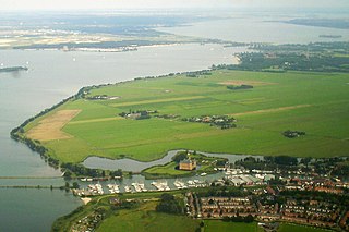
Ouderkerk aan den IJssel is a village in the municipality of Krimpenerwaard, in the province of South Holland, the Netherlands. It is situated along the river Hollandse IJssel and has over 4000 inhabitants.

<span class="mw-page-title-main">Krimpenerwaard</span> Municipality in South Holland, Netherlands

Krimpenerwaard is a municipality, a region and a former water board of the Netherlands. It is a rural area located in the east of the province of South Holland, just south of Gouda and east of the Rotterdam conurbation. It is bordered on the north by the river Hollandse IJssel, on the south by the river Lek and on the east by the stream Vlist.

<span class="mw-page-title-main">Rhine–Meuse–Scheldt delta</span> Delta formed by 3 rivers in the Netherlands

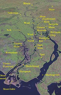
The Rhine–Meuse–Scheldt delta is a river delta in the Netherlands formed by the confluence of the Rhine, the Meuse and the Scheldt rivers. In some cases, the Scheldt delta is considered a separate delta to the Rhine–Meuse delta. The result is a multitude of islands, branches and branch names that may at first sight look bewildering, especially as a waterway that appears to be one continuous stream may change names as many as seven times, e.g. Rhine → Bijlands Kanaal → Pannerdens Kanaal → Nederrijn → Lek → Nieuwe Maas → Het Scheur → Nieuwe Waterweg. Since the Rhine contributes most of the water, the shorter term Rhine Delta is commonly used. However, this name is also used for the delta where the Alpine Rhine flows into Lake Constance, so it is clearer to call the larger one Rhine–Meuse delta, or even Rhine–Meuse–Scheldt delta, as the Scheldt ends in the same delta. By some calculations, the delta covers 25,347 km2 (9,787 sq mi), making it the largest in Europe.

Vaartse Rijn

The Vaartse Rijn is a canal connecting the city of Utrecht with Nieuwegein and the Lek river in the Dutch province of Utrecht. The Vaartse Rijn was formerly a major shipping route between Utrecht and the Rhine basin.

<span class="mw-page-title-main">Frisian Water Line</span>

The building of the Friese Waterlinie started around 1580. The traject of the defenceline starts at the Zuidersea, along the river Linde until the De Blessebridge. Then the defence line goes to the north to Kuinre along Heerenveen, Terband, Gorredijk, Donkerbroek, Bakkeveen until Frieschepalen.

<span class="mw-page-title-main">Wierickerschans</span>

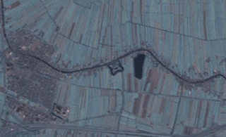
The Wierickerschans Fort is a part of the Old Dutch Waterline or "Oude Hollandse Waterlinie". This was a defence system that allowed large parts of the country (Holland) to be flooded (inundated). Thus protecting the main towns and city in the West against invading forces from the East. It was in use right up to the 19th century. The Fort was built on the site where in 1672 Stadtholder Willem III had his headquarters during the war against the French. The Fort is centrally located within the Old Dutch Waterline that stretched from Muiden down to the Biesbosch.

<span class="mw-page-title-main">IJssel Line</span>

The IJssel Line was the Dutch portion of the NATO Cold War line of defence for Western Europe during the 1950s and 1960s. It consisted of anti-aircraft and four-barrel machine gun bunkers, command and hospital bunkers, and many Ram and Sherman tank bunkers encased in concrete, leaving the turrets exposed. These elements were placed along the IJssel river.

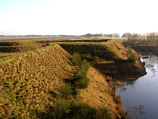
Schielands Hoge Zeedijk, formerly called Hoogendijk is a Dutch dike in the province of South Holland that stretches from the Schie at Schiedam to the Gouwe near Gouda. Constructed in the 13th century, the dike continues to protect an area inhabited by 3 million people from flooding by the North Sea.

This is a list of cities, towns and village flags in the Netherlands. The flags are listed per province.

<span class="mw-page-title-main">West Brabant waterline</span>

The West Brabant waterline is a Dutch military defense line based on inundation.

References