Tungawan | |
---|---|
Municipality of Tungawan | |
Map of Zamboanga Sibugay with Tungawan highlighted | |
Location within the Philippines | |
Coordinates: 7°30′N122°22′E / 7.5°N 122.37°E Coordinates: 7°30′N122°22′E / 7.5°N 122.37°E | |
Country | |
Region | Zamboanga Peninsula (Region IX) |
Province | Zamboanga Sibugay |
District | 2nd District |
Founded | May 24, 1960 |
Barangays | 25 (see Barangays) |
Government | |
• Type | Sangguniang Bayan |
• Mayor | Carlnan C. Climaco |
• Vice Mayor | Ivan N. Balano |
• Congressman | Dulce Ann K. Hofer |
• Electorate | 22,981 voters (2016) |
Area | |
• Total | 473.28 km2 (182.73 sq mi) |
Population (2015 census) [3] | |
• Total | 42,030 |
• Density | 89/km2 (230/sq mi) |
Time zone | UTC+8 (PST) |
ZIP code | 7018 |
PSGC | |
IDD : area code | +63 (0)62 |
Climate type | Tropical climate |
Income class | 2nd municipal income class |
Revenue (₱) | 144.1 million (2016) |
Native languages | Subanon language Cebuano Chavacano Tagalog |
Website | www |
Tungawan, officially the Municipality of Tungawan, is a 2nd class municipality in the province of Zamboanga Sibugay, Philippines. According to the 2015 census, it has a population of 42,030 people. [3]
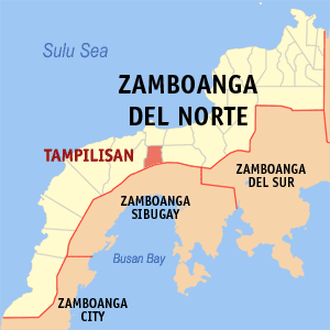
Zamboanga Sibugay is a province in the Philippines located in the Zamboanga Peninsula region in Mindanao. Its capital is Ipil and it borders Zamboanga del Norte to the north, Zamboanga del Sur to the east and Zamboanga City to the southwest. To the south lies Sibuguey Bay in the Moro Gulf.
The Philippines, officially the Republic of the Philippines, is an archipelagic country in Southeast Asia. Situated in the western Pacific Ocean, it consists of about 7,641 islands that are categorized broadly under three main geographical divisions from north to south: Luzon, Visayas and Mindanao. The capital city of the Philippines is Manila and the most populous city is Quezon City, both part of Metro Manila. Bounded by the South China Sea on the west, the Philippine Sea on the east and the Celebes Sea on the southwest, the Philippines shares maritime borders with Taiwan to the north, Japan to the northeast, Vietnam to the west, Palau to the east, and Malaysia and Indonesia to the south.
It has an area of 47,328 hectares (116,950 acres) of land, the largest in the province, as well as 15,236 hectares (37,650 acres) of coastal waters.
It was declared as a Municipality on May 24, 1959, and started functioning as an LGU on January 29, 1961, by virtue of Executive Order No. 395. [4] Its name was coined from the minute leech generally known as “tungaw” of the Hirudo family.
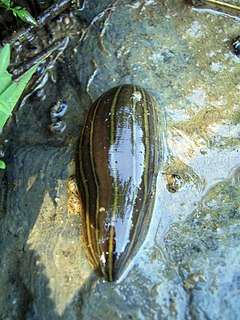
Hirudo is a genus of leeches of the family Hirudinidae. It was described by Linnaeus in 1758.
Tungawan's economy is primarily based on agriculture, producing rubber, coconut, corn, rice, and seaweeds. It is home to the 880 hectares Bangaan Marine Sanctuary at Barangays Linguisan and Tigbucay.
Tungawan is politically subdivided into 25 barangays.
A barangay or baranggay, formerly referred to as barrio, is the smallest administrative division in the Philippines and is the native Filipino term for a village, district or ward. In metropolitan areas, the term often refers to an inner city neighbourhood, a suburb or a suburban neighborhood. The word barangay originated from balangay, a kind of boat used by a group of Austronesian peoples when they migrated to the Philippines.
Poblacion or población is the common term used for the central, downtown, old town or central business district area of a Philippine city or municipality, which may take up the area of a single barangay or multiple barangays. It is sometimes shortened to Pob.
Population census of Tungawan | ||
---|---|---|
Year | Pop. | ±% p.a. |
1970 | 11,838 | — |
1975 | 9,573 | −4.17% |
1980 | 10,679 | +2.21% |
1990 | 26,005 | +9.31% |
1995 | 28,552 | +1.77% |
2000 | 33,194 | +3.28% |
2007 | 37,588 | +1.73% |
2010 | 40,552 | +2.80% |
2015 | 42,030 | +0.68% |
Source: Philippine Statistics Authority [3] [5] [6] [7] |
Alicia, officially the Municipality of Alicia, is a 3rd class municipality in the province of Zamboanga Sibugay, Philippines. According to the 2015 census, it has a population of 36,013 people.
Diplahan, officially the Municipality of Diplahan, is a 3rd class municipality in the province of Zamboanga Sibugay, Philippines. According to the 2015 census, it has a population of 32,428 people.
Imelda, officially the Municipality of Imelda, is a 4th class municipality in the province of Zamboanga Sibugay, Philippines. According to the 2015 census, it has a population of 28,018 people.
Kabasalan, officially the Municipality of Kabasalan, is a 2nd class municipality in the province of Zamboanga Sibugay, Philippines. According to the 2015 census, it has a population of 44,336 people.
Mabuhay, officially the Municipality of Mabuhay, is a 4th class municipality in the province of Zamboanga Sibugay, Philippines. According to the 2015 census, it has a population of 36,870 people.
Naga, officially the Municipality of Naga, is a 3rd class municipality in the province of Zamboanga Sibugay, Philippines. According to the 2015 census, it has a population of 38,547 people.
Olutanga, officially the Municipality of Olutanga, is a 4th class municipality in the province of Zamboanga Sibugay, Philippines. According to the 2015 census, it has a population of 33,671 people.
Payao, officially the Municipality of Payao, is a 3rd class municipality in the province of Zamboanga Sibugay, Philippines. According to the 2015 census, it has a population of 31,686 people.
Roseller Lim, officially the Municipality of Roseller Lim, is a 3rd class municipality in the province of Zamboanga Sibugay, Philippines. According to the 2015 census, it has a population of 43,646 people.
The Municipality of Siay is Located in the 2nd District and Eastern part of the Province of Zamboanga Sibugay. It is thirty eight (38) kilometers from Ipil, Two Hundred twenty (220) kilometers to Dipolog City and (180) Kilometers East to Zamboanga City. It is geographically situated within a map coordination of 741 east & 122* 53*west.
Talusan, officially the Municipality of Talusan, is a 5th class municipality in the province of Zamboanga Sibugay, Philippines. According to the 2015 census, it has a population of 29,969 people.
Titay, officially the Municipality of Titay, is a 2nd class municipality in the province of Zamboanga Sibugay, Philippines. According to the 2015 census, it has a population of 49,673 people.
Leon B. Postigo, officially the Municipality of Leon B. Postigo, is a 4th class municipality in the province of Zamboanga del Norte, Philippines. According to the 2015 census, it has a population of 26,221 people.
La Libertad, officially the Municipality of La Libertad, is a 5th class municipality in the province of Zamboanga del Norte, Philippines. According to the 2015 census, it has a population of 8,406 people.
Mutia, officially the Municipality of Mutia, is a 5th class municipality in the province of Zamboanga del Norte, Philippines. According to the 2015 census, it has a population of 12,675 people.
Tampilisan, officially the Municipality of Tampilisan, is a 4th class municipality in the province of Zamboanga del Norte, Philippines. According to the 2015 census, it has a population of 24,307 people.
Aurora, officially the Municipality of Aurora, is a 2nd class municipality in the province of Zamboanga del Sur, Philippines. According to the 2015 census, it has a population of 50,755 people.
Labangan, officially the Municipality of Labangan, is a 3rd class municipality in the province of Zamboanga del Sur, Philippines. According to the 2015 census, it has a population of 41,790 people.
San Miguel, officially the Municipality of San Miguel, is a 4th class municipality in the province of Zamboanga del Sur, Philippines. According to the 2015 census, it has a population of 19,205 people.
Tambulig, officially the Municipality of Tambulig, is a 4th class municipality in the province of Zamboanga del Sur, Philippines. According to the 2015 census, it has a population of 36,160 people.
This article about a location in Zamboanga Peninsula region is a stub. You can help Wikipedia by expanding it. |