North Bend is a city in King County, Washington, United States, on the outskirts of the Seattle metropolitan area. The population was 5,731 at the 2010 census and an estimated 7,136 in 2018.

Snoqualmie Falls is a 268-foot (82 m) waterfall in the northwest United States, located east of Seattle on the Snoqualmie River between Snoqualmie and Fall City, Washington. It is one of Washington's most popular scenic attractions, but is perhaps best known internationally for its appearance in the cult television series Twin Peaks. More than 1.5 million visitors come to the Falls every year, where there is a two-acre park, an observation deck, and a gift shop.

Rock Island State Park is a state park in Warren County and White County, Tennessee, located in the Southeastern United States. The park is named after the community of Rock Island, Tennessee, which in turn received its name from an island on the Caney Fork upstream from the Collins River confluence and Great Falls Dam. Rock Island State Park is centered on a peninsula created by the confluence of these two rivers and extends downstream to the headwaters of Center Hill Lake.

Tumwater Falls are a series of cascades on the Deschutes River in Tumwater, Washington, United States, near where the river empties into Budd Inlet, a southerly arm of Puget Sound in Olympia.
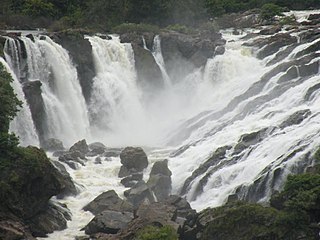
Shivanasamudra is a small town in the Chamarajanagar District of the state of Karnataka, India. It is situated on the banks of the river Kaveri, which forms here the boundary to the mandya District, and is the location of one of the first hydro-electric power stations in Asia, which was set up in 1902.The project was designed by Diwan Sheshadri Iyer.
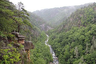
Tallulah Gorge State Park is a 2,689-acre (1,088 ha) Georgia state park adjacent to Tallulah Falls, Georgia along the county line between Rabun and Habersham Counties. The park surrounds Tallulah Gorge, a 1,000-foot (300 m) deep gorge formed by the action of the Tallulah River, which runs along the floor of the gorge. The major attractions of the gorge are the six waterfalls known as the Tallulah Falls, which cause the river to drop 500 feet over one mile.

Iron Horse State Park, part of the Washington State Park System, is a 1,612-acre (7 km2) state park located in the Cascade Mountains and Yakima River Valley, between Cedar Falls on the west and the Columbia River on the east.

Ohiopyle State Park is a Pennsylvania state park on 19,052 acres (7,710 ha) in Dunbar, Henry Clay and Stewart Townships, Fayette County, Pennsylvania in the United States. The focal point of the park is the more than 14 miles (23 km) of the Youghiogheny River Gorge that passes through the park. The river provides some of the best whitewater boating in the Eastern United States. Ohiopyle State Park is bisected by Pennsylvania Route 381 south of the Pennsylvania Turnpike. The park opened to the public in 1965, but was not officially dedicated until 1971.

Silver Falls State Park is a state park in the U.S. state of Oregon, located near Silverton, about 20 miles (32 km) east-southeast of Salem. It is the largest state park in Oregon with an area of more than 9,000 acres (36 km2), and it includes more than 24 miles (39 km) of walking trails, 14 miles (23 km) of horse trails, and a 4-mile (6.4 km) bike path. Its 8.7-mile (14.0 km) Canyon Trail/Trail of Ten Falls runs along the banks of Silver Creek and by ten waterfalls, from which the park received its name. Four of the ten falls have an amphitheater-like surrounding that allows the trail to pass behind the flow of the falls. The Silver Falls State Park Concession Building Area and the Silver Creek Youth Camp-Silver Falls State Park are separately listed on the U.S. National Register of Historic Places.

The Palouse to Cascades State Park Trail, formerly known as the John Wayne Pioneer Trail, is a rail trail that spans most of the U.S. state of Washington. It follows the former railway roadbed of the Chicago, Milwaukee, St. Paul & Pacific Railroad for 300 miles (480 km) across two-thirds of the state, from the western slopes of the Cascade Mountains to the Idaho border.
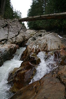
Weeks Falls is a waterfall on the South fork of the Snoqualmie River, located just south of Interstate 90 at exit 38. The falls are at the end of the road that goes past the Olallie State Park ranger headquarters. From the gravel parking lot, there is a paved accessible overlook to see the falls and a small area around the hydro-electric plant. Also, there is a 1/4 mile accessible interpretive trail nearby.
Upper Weeks Falls is a waterfall on the South fork of the Snoqualmie River. It is located south of Interstate 90

Bridal Veil Falls is a 1,328-foot (405 m) waterfall that flows from Lake Serene directly to the South Fork Skykomish River on the creek of the same name in the U.S. state of Washington. It is a perennial 150-foot (46 m) wide drop with four tiers, two of which are clearly visible. It is at 47.78950°N 121.56924°W.
The Taylor River is a river in King County in Washington.

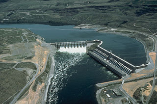
The Snoqualmie Falls Hydroelectric Plant is located just north of Snoqualmie in King County, Washington state, US. It is situated about 22 mi (35 km) east of Seattle. Located just below the Snoqualmie Falls, the power plant consists of two power houses, Plant 1 and Plant 2. Plant 1 was completed in 1899 and is located underground. It is the first completely underground hydroelectric power plant ever built in the world. Plant 2 was built in 1910 and is located along the right bank of the Snoqualmie River. Both plants receive water from a small reservoir created by a weir atop the falls. Plant 1 has an installed capacity of 13.7 MW and Plant 2 a capacity of 40.2 MW for a total installed capacity of 53.9 MW, enough to power 40,000 homes.