Tz'utujil people

Last updated
Tz'utujil
Total population
78,498 [1]
Regions with significant populations
Flag of Guatemala.svg  Guatemala [2]
Languages
Tz'utujil
Related ethnic groups
K'iche', Kaqchikel
Tz'utujil men in Santiago Atitlan Santiago de atitlan natives 2009.JPG
Tz'utujil men in Santiago Atitlán

The Tz'utujil (Tzutujil, Tzutuhil, Sutujil) are a Native American people, one of the 21 Maya ethnic groups that dwell in Guatemala. Together with the Xinca, Garífunas (Black Caribs) and the Ladinos, they make up the 24 ethnic groups in this relatively small country. Approximately 100,000 Tz'utujil live in the area around Lake Atitlán. Their pre-Columbian capital, near Santiago Atitlán, was Chuitinamit. In pre-Columbian times, the Tz'utujil nation was a part of the ancient Maya civilization.

Indigenous peoples of the Americas Pre-Columbian inhabitants of North, Central, and South America and their descendants

The indigenous peoples of the Americas are the Pre-Columbian peoples of North, Central and South America and their descendants.

Maya peoples People of southern Mexico and northern Central America

The Maya peoples are a large group of Indigenous peoples of Mesoamerica. They inhabit southern Mexico, Guatemala, Belize, El Salvador and Honduras. The overarching term "Maya" is a collective designation to include the peoples of the region that share some degree of cultural and linguistic heritage; however, the term embraces many distinct populations, societies, and ethnic groups that each have their own particular traditions, cultures, and historical identity.

Guatemala republic in Central America

Guatemala, officially the Republic of Guatemala, is a country in Central America bordered by Mexico to the north and west, Belize and the Caribbean to the northeast, Honduras to the east, El Salvador to the southeast and the Pacific Ocean to the south. With an estimated population of around 16.6 million, it is the most populated country in Central America. Guatemala is a representative democracy; its capital and largest city is Nueva Guatemala de la Asunción, also known as Guatemala City.

Contents

The Tz'utujil are noted for their continuing adherence to traditional cultural and religious practices. Evangelical Protestantism and Roman Catholicism are also practiced among them. They speak the Tz'utujil language, a member of the Mayan language family.

Mayan languages language family spoken in Mesoamerica

The Mayan languages form a language family spoken in Mesoamerica and northern Central America. Mayan languages are spoken by at least 6 million Maya peoples, primarily in Guatemala, Mexico, Belize and Honduras. In 1996, Guatemala formally recognized 21 Mayan languages by name, and Mexico recognizes eight more within its territory.

History and demographics

The Tz'utujil date from the post-classic period (circa 900-1500) of the Maya civilization, inhabiting the southern watershed of Lake Atitlán, in the Solola region of the Guatemalan highlands.

Maya civilization Mesoamerican civilization

The Maya civilization was a Mesoamerican civilization developed by the Maya peoples, and noted for its logosyllabic script—the most sophisticated and highly developed writing system in pre-Columbian Americas—as well as for its art, architecture, mathematics, calendar, and astronomical system. The Maya civilization developed in an area that encompasses southeastern Mexico, all of Guatemala and Belize, and the western portions of Honduras and El Salvador. This region consists of the northern lowlands encompassing the Yucatán Peninsula, and the highlands of the Sierra Madre, running from the Mexican state of Chiapas, across southern Guatemala and onwards into El Salvador, and the southern lowlands of the Pacific littoral plain.

Sololá Department Department in Sololá, Guatemala

Sololá is a department in the west of Guatemala. The capital is the city of Sololá. Lake Atitlan is a key feature surrounded by a number of the municipalities.

Today they dwell in the towns of San Juan La Laguna, San Pablo La Laguna, San Marcos La Laguna, San Pedro La Laguna, Santiago Atitlán, Panabaj, Tzanchaj (believed to have been the inspiration, because of its similar sound, for the name "Santiago"), and a very few in San Lucas Tolimán, although they used to inhabit a much wider region. In 1523 the Spanish conquistador Pedro de Alvarado, with the help of the Kaqchikel Maya, defeated them in a battle close to the town of Panajachel in which they lost a portion of their lands, and the control of the lake.

San Juan La Laguna Municipality and town in Sololá, Guatemala

San Juan La Laguna is a municipality on the southern shore of Lago de Atitlán, Sololá, Guatemala. It consists of the village named San Juan La Laguna and three smaller aldeas in the nearby mountain. The population is approximately 95% Tz'utujil. Agriculture is most important for the economy, with the service sector growing, especially as the number of tourists increase. The lowest elevation is the shore of Lago Atitlán at 1,562 metres (5,125 ft).

San Pablo La Laguna Municipality in Sololá department, Guatemala

San Pablo La Laguna is a municipality in the Sololá department of Guatemala. It consists of the village that bears the name San Pablo La Laguna which is situated on the shore of Lake Atitlan between the villages of San Juan La Laguna and San Marcos La Laguna.

San Marcos La Laguna village in Sololá, Guatemala

San Marcos La Laguna is a village on the western shore of Lago Atitlán in the Sololá Department of Guatemala. The village is northwest of three volcanos Volcán San Pedro, Volcán Tolimán, and Volcán Atitlán. The village has an outdoor amphitheater and a few hostels. San Marcos connects to other lakeside communities by boat and a narrow road. The nearest city is Panajachel at the northern side of Lago Atitlán. The town sits at an elevation of 1,585 metres (5,200 ft); the lowest elevation is the lake shore at 1,562 metres (5,125 ft).

In 2005, several hundred Tz'utujil died in the mudslides caused by Hurricane Stan. From Panabaj and Tzanchaj, rescuers recovered 160 bodies, while 250 remained missing from both towns.

Hurricane Stan Category 1 Atlantic hurricane in 2005

Hurricane Stan was a rather weak but deadly tropical cyclone that affected areas of Central America in early October 2005. The eighteenth named storm and eleventh hurricane of the 2005 Atlantic hurricane season, Stan formed from a tropical wave on October 1 after it had moved into the western Caribbean Sea. The depression slowly intensified, and reached tropical storm intensity the following day, before subsequently making its first landfall on the Yucatán Peninsula. Traversing the peninsula, the tropical storm weakened, but was able to re-intensify once it entered the Bay of Campeche. Under favorable conditions for tropical development, Stan attained hurricane strength on October 4, and later reached peak intensity with winds of 80 mph (130 km/h) and a minimum barometric pressure of 977 mbar. The hurricane maintained this intensity until landfall near Punta Roca Partida, Mexico later the same day. Once over the mountainous terrain of Mexico, however, Stan quickly weakened, and dissipated on October 5.

Economics

Although tourism is now an increasing source of income, many still practice traditional methods of farming of the two main crops in the region, coffee and maize (corn). Tourism is benefiting most significantly from the work of talented artists and weavers who are anxious to gain recognition for the creativity and uniqueness they offer. San Juan is one of three Tz'utujil communities where artists have adapted the international genre of Arte Naif to express the cultural traditions, beliefs, ceremonies and daily activities of their indigenous culture. This form of art and its most accomplished of the Tz'utjil practitioners have been recognized in the definitive UNESCO-sponsored book on the subject, Arte Naif: Contemporary Guatemalan Mayan Painting, 1998. The weavers of San Juan are among the very few indigenous artisans who make their own dyes for the thread they use; they produce the dyes largely from plants grown locally.

Coffee Brewed beverage

Coffee is a brewed drink prepared from roasted coffee beans, the seeds of berries from certain Coffea species. The genus Coffea is native to tropical Africa and Madagascar, the Comoros, Mauritius, and Réunion in the Indian Ocean. Coffee plants are now cultivated in over 70 countries, primarily in the equatorial regions of the Americas, Southeast Asia, Indian subcontinent, and Africa. The two most commonly grown are C. arabica and C. robusta. Once ripe, coffee berries are picked, processed, and dried. Dried coffee seeds are roasted to varying degrees, depending on the desired flavor. Roasted beans are ground and then brewed with near-boiling water to produce the beverage known as coffee.

Maize Cereal grain

Maize, also known as corn, is a cereal grain first domesticated by indigenous peoples in southern Mexico about 10,000 years ago. The leafy stalk of the plant produces pollen inflorescences and separate ovuliferous inflorescences called ears that yield kernels or seeds, which are fruits.

See also

Related Research Articles

Alta Verapaz Department Departments of Guatemala

Alta Verapaz is a department in the north central part of Guatemala. The capital and chief city of the department is Cobán. Verapaz is bordered to the north by El Petén, to the east by Izabal, to the south by Zacapa, El Progreso, and Baja Verapaz, and to the west by El Quiché.

Kʼicheʼ are indigenous peoples of the Americas and are one of the Maya peoples. The Kʼicheʼ language is a Mesoamerican language in the Mayan language family. The highland Kʼicheʼ states in the pre-Columbian era are associated with the ancient Maya civilization, and reached the peak of their power and influence during the Mayan Postclassic period. The meaning of the word Kʼicheʼ is "many trees". The Nahuatl translation, Cuauhtēmallān "Place of the Many Trees (People)", is the origin of the word Guatemala. Quiché Department is also named for them. Rigoberta Menchú, an activist for indigenous rights who won the Nobel Peace Prize in 1992, is perhaps the best-known Kʼicheʼ.

Quiché Department Department in Guatemala

Quiché is a department of Guatemala.

Lake Atitlán crater lake in the Western Highlands of Guatemala

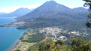
Lake Atitlán is a lake in the Guatemalan Highlands of the Sierra Madre mountain range. It is in the Sololá Department of southwestern Guatemala. It is the deepest lake in Central America

Maximón Mayan folk god

Maximón, also called San Simón, is a Mayan deity and folk saint represented in various forms by the Maya people of several towns in the highlands of Western Guatemala. Oral tradition of his creation and purpose in these communities is complex, diverse, and born of the ancient Maya traditions centuries ago.

Panajachel City and Municipality in Sololá, Guatemala

Panajachel is a town in the southwestern Guatemalan Highlands, less than 90 miles from Guatemala City, in the department of Sololá. It serves as the administrative centre for the surrounding municipality of the same name. The elevation is 1,597 metres (5,240 ft). Population was 11 thousand in the 2000 census, estimated as 15,000 now (Insituto Nacional de Estadística de Guatemala), and has approximately doubled each of the last few decades. The town of Panajachel is located on the Northeast shore of Lake Atitlán, and has become a centre for the tourist trade of the area as it provides a base for visitors crossing the lake to visit other towns and villages.

San Pedro Soloma Municipality in Huehuetenango, Guatemala

San Pedro Solóma is a municipality of Huehuetenango, a department of Guatemala. It is located in the Sierra de los Cuchumatanes at 2,300 m above sea level. The municipality covers a total area of 264 km2 with elevations ranging from 1,900 m to 3,500 m. Its population of 47,688 people is spread over the town of Soloma, 19 villages and 50 smaller rural communities (caserios).

San Pedro La Laguna Municipality in Sololá, Guatemala

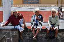
San Pedro La Laguna is a Guatemalan town on the southwest shore of Lake Atitlán. For centuries, San Pedro La Laguna has been inhabited by the Tz'utujil people, and in recent years it has also become a tourist destination for its Spanish language schools, night life, and proximity to the lake and volcanos.

Santa Cruz La Laguna Municipality and town in Sololá, Guatemala


Santa Cruz La Laguna is a municipality located on the northern shore of Lago de Atitlán in the Sololá department of Guatemala. It consists of the villages of Santa Cruz La Laguna and Tzununá as well as four smaller villages (caseríos). As of 2018 the estimated population is 9,392 people and the area is populated almost entirely by the Kaq'chikel indigenous Maya people.

Santiago Atitlán City in Sololá, Guatemala

Santiago Atitlán is a municipality in the Sololá department of Guatemala. The town is situated on Lago de Atitlán, which has an elevation of 5,105 feet (1,556 m). The town sits on a bay of Lago Atitlan between two volcanos. Volcan San Pedro rises to 2,846 metres (9,337 ft) west of town; Volcan Toliman rises to 3,144 metres (10,315 ft) southeast of town. Volcan Atitlan, with a summit of 3,516 metres (11,535 ft), is south-southeast of town. Santiago Atitlan is southwest of Panajachel across the lake. Major highways reach Lago Atitlan at San Lucas Toliman and Panajachel. A road links Santiago to San Lucas Tolliman. Boats connect the numerous communities around Lago Atitlan.

The Kaqchikel language is an indigenous Mesoamerican language and a member of the Quichean–Mamean branch of the Mayan languages family. It is spoken by the indigenous Kaqchikel people in central Guatemala. It is closely related to the Kʼicheʼ (Quiché) and Tzʼutujil languages.

Panabaj, located on the edge of Lake Atitlán in the western highlands of Guatemala, is a small village within the municipality of Santiago Atitlán, bordering the city of Santiago Atitlán proper, in the department of Sololá. Prior to the disaster of Hurricane Stan in which over 400 persons from Panabaj and nearby Tzanchaj were killed or left missing, the town's population had numbered over 3,000, though a census has not been taken since.

Mam people Ethnicity in Central America

The Mam are an indigenous people in the western highlands of Guatemala and in south-western Mexico who speak the Mam language.

Tzʼutujil is a Mayan language spoken by the Tzʼutujil people in the region to the south of Lake Atitlán in Guatemala. Tzʼutujil is closely related to its larger neighbors, Kaqchikel and Kʼicheʼ. The 2002 census found 60,000 people speak Tzʼutujil as their mother tongue. The two Tzʼutijil dialects are Eastern and Western.

The Chʼortiʼ people are one of the indigenous Maya peoples, who primarily reside in communities and towns of southeastern Guatemala, northwestern Honduras, and northern El Salvador. Their indigenous language, also known as Chʼortiʼ, is a survival of Classic Choltian, the language of the inscriptions in Copan. It is the first language of approximately 15,000 people, although the majority of present-day Chʼortiʼ speakers are bilingual in Spanish as well.

The Guatemala Health Initiative (GHI) is a private, humanitarian organization that works to improve the health of the poor, indigenous population in the remote areas of the western highlands in Guatemala. (Penn) faculty, students, and staff work in partnership to serve the health issues of the underprivileged Santiago Atitlán community in Guatemala. The goal of GHI is to strengthen clinical services and promote community health in resource-poor Guatemalan communities.

Paula Nicho Cumez Guatemalan artist

Paula Nicho Cumez is a Mayan-Guatemalan artist. Cumez is inspired by Mayan tradition and culture and focuses on expressing the context of native women’s experience in her artwork; additionally, Cumez was inspired by the Popol Vuh. Cumez is known for creating an artist community of women within the Tz’uthil Mayan artists, named "Kaqchikel Surrealist Painters.” Additionally, a short film was made about Paula Nicho Cumez’s background called Del Azul al Cielo.

References

  1. According to the official 2002 census: "XI Censo Nacional de Población y VI de Habitación (Censo 2002) - Pertenencia de grupo étnico". Instituto Nacional de Estadísticas. 2002. Retrieved 2008-05-27. Note that the Summer Institute of Linguistics (SIL) mentions a higher number
  2. Ethnologue report for Guatemala
  3. http://stanleyrother.org/about/