Chuj people

Last updated
Chuj
Total population
c. 94,000
Regions with significant populations
Flag of Guatemala.svg  Guatemala 91,391 [1]
Huehuetenango 89,663 [1]
Flag of Mexico.svg  Mexico approx. 3,000 [2]
Languages
Chuj, Spanish
Religion
Catholic, Evangelicalist, Maya religion

The Chuj or Chuh [3] are a Maya people, whose homeland is in Guatemala and Mexico. Population estimates vary between 30,000 and over 60,000. Their indigenous language is also called Chuj and belongs to the Q'anjobalan branch of Mayan languages. Most Chuj live in the Guatemalan department of Huehuetenango, in the municipalities of San Mateo Ixtatán and San Sebastián Coatán, with small numbers also residing in the neighboring border areas of the Mexican state of Chiapas. Los Angeles is believed to have a relatively large population of undocumented Chuj immigrants.

Contents

The Chuj, and their ancestors, are believed to have lived in the same area for 4,000 years. They first came into contact with Spanish conquistadores in the 1530s; however, they were not finally subdued by the Spanish colonial authorities until the 1680s. In the post-Colonial era, the Chuj lost much of their communal land, reducing them to extreme poverty. This resulted in a history of violent resistance to authority culminating in guerrilla activity against Guatemala's military junta in the 1980s.

Ethnonym

Red circle.svg
Relief map of Central America.jpg
Central America. Circled in red, the homeland of the Chuj in the highlands of north western Guatemala and adjacent areas of the Mexican state of Chiapas.

The name Chuj is an exonym first used by the Spanish. [4] According to folk tradition, the term was coined by Tzeltal conscripts of the Spanish, for whom it meant the loose wool overgarment traditionally worn by Chuj men. [4] The Chuj themselves use an autonym based on their town of origin, i.e. ajSan Matéyo (from San Mateo Ixtatán), ajSan Sabastyán (from San Sebastián Coatán), or ajNenton (from Nentón). [4]

Overview and demographics

The Chuj are a small grouping of Mayan people who live in Guatemala [5] and Mexico. [6] Following emigration to the United States in the 1980s, large numbers of the Chuj also live in Los Angeles. [4]

Most of the Chuj live in Guatemala, in the highlands of the department of Huehuetenango. [5] Their main centres of settlement in Huehuetenango are the towns of San Mateo Ixtatán and San Sebastián Coatán with some living in parts of the town of Nentón. [6] Additionally, small numbers also live in the Mexican state of Chiapas. [6]

Estimates of total numbers vary from 30,000 [5] to over 60,000. [7] The populations of San Mateo Ixtatán and San Sebastián Coatán, both of which are almost wholly Chuj, are about 16,000 and 9,000 respectively. [4] There are nearly 4,000 Chuj-speakers in Nentón constituting about a third of the town. [4] Because of the irregular immigrant status of the Chuj in the U.S., it is not known how many Chuj live in Los Angeles, but one estimate is that it equals the population of San Sebastián Coatán. [4]

In Guatemala, the Chuj have a reputation for rebelliousness and antagonism to authority, the historic causes of which arise out of poverty and grievances over land distribution. [8]

History

Red circle 50%25.svg
Contact Period lowland Guatemala.gif
North Guatemala at the time of first contact with the Spanish: Chuj territory circled in red.

Pre-Columbian era

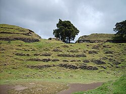
The Chuj live in an area believed to have been the Proto-Mayan language homeland and they and their ancestors are thought to have lived there continuously since Proto-Maya began splitting into the modern Maya languages about 4,000 years ago. [4] There is, on the outskirts of the modern town of San Mateo Ixtatán, archaeological evidence of a Chuj urban settlement, Wajxaklajun, also known as Ystapalapán, which includes mounds and plazas and dates from between 600 and 900 A.D. [4]

Like other Maya, the Chuj were a settled farming people who cultivated maize and beans. [5] As far as the Chuj's political history is concerned, it is known that they were subject to K'iche' domination in the 15th century but freed themselves from K'iche' control in the early 16th century. [5]

Spanish conquest

The Spanish conquest of the Maya territories of the Guatemalan highlands began in 1524 when the conquistador Pedro de Alvarado led his army into the region. [9] In 1529 the Chuj city of San Mateo Ixtatán (that is, Wajxaklajun) was given in encomienda to Gonzalo de Ovalle (es), a companion of Pedro de Alvarado, together with Santa Eulalia and Jacaltenango. In the 1530s, the Chuj submitted to the Spanish conquest [5] and, in 1549, the first Chuj reduccion was established at San Mateo Ixtatán, overseen by Dominican missionaries. [10] The Chuj of San Mateo Ixtatán remained rebellious and resisted Spanish control for longer than their highland neighbours; their resistance was so determined that the Chuj remained pacified only while the immediate effects of the Spanish expeditions lasted. [11] But the longer-term effect was that disease and warfare substantially reduced Chuj numbers in the 16th century. [5]

San Mateo Ixtatan 2.jpg
The ruins of Wajxaklajun, the pre-Columbian Chuj settlement at San Mateo Ixtatán
Guatemala 2007 tarjeta 2 198.jpg
The modern city of San Mateo Ixtatán, still the home of many of the Chuj

In the late 17th century, the Spanish missionary Alonso de León reported that about eighty families lived in San Mateo Ixtatán but that they did not pay tribute to the Spanish Crown or attend the Roman Catholic mass. He described the inhabitants as "quarrelsome" and complained that their religious practices were such that they were Christian in name only: they had built a pagan shrine in the hills among the ruins of pre-Columbian temples, where they burnt incense and offerings and sacrificed turkeys. Eventually, de León was driven out of San Mateo Ixtatán by the Chuj. [12]

In 1684, Enrique Enriquez de Guzmán, the governor of Guatemala, decided on the final conquest of the region. [13] In 1686, the Governor himself arrived in San Mateo Ixtatán, after sending in troops under Captain Melchor Rodríguez Mazariegos, and successfully took control of the town. After recruiting Chuj warriors from the nearby villages, including 61 from San Mateo itself, [14] [15] he launched an invasion of the still unconquered Lacandon region from San Mateo Ixtatán and completed the conquest of the area. [15]

Post-colonial era

Guatemala gained its independence from Spain in 1821. In the late 19th century the Guatemalan government sanctioned the transfer of Chuj tribal land to powerful agricultural land owners. [5] The process began in 1876, when they were forced to cede land to create the new municipality of Nenton. [16] In the fighting that followed, the Chuj managed to maintain their communal lands in the high mountains, and this prompted their modern reputation for rebelliousness. [16] With the loss of much of their land, and the resultant extreme poverty, many of the Chuj were forced to migrate to Guatemala's southern coast. [16] As a people, they were reduced to becoming either peasants or migrant labourers. [5]

In the years that followed, the Chuj were involved in frequent uprisings and violent unrest [16] caused by extreme poverty and a sense of grievance because of the loss of their lands. [17] Political unrest and bloody reprisals against the Chuj increased after the Second World War. [5] By the 1970s, violent confrontations with the Guatemalan police were common. [18] In the late 1970s and early 1980s the confrontation with Guatemalan authorities became focused on the Chuj campaign to preserve their forests in the region. [19] By the 1980s, when Guatemala was ruled by a military junta, the Chuj were involved in full-scale guerrilla activity against the Army, who regarded them as "internal enemies". [19] During the decade, about 25% of the Chuj emigrated to the United States. [5]

Culture

Chuj folk art: a Chuj woman with text in the Chuj language alluding to Maya corn culture Idioma Chuj.JPG
Chuj folk art: a Chuj woman with text in the Chuj language alluding to Maya corn culture

Language

The Chuj historically speak a language, also called Chuj, which is part of the Q'anjobalan branch of the Mayan languages. It is most closely related to Tojolab'al, spoken in Mexico. [4] The Chuj now also speak Spanish and are bi-lingual. [4]

Although the Chuj language remains viable, as with other Mayan languages, children, particularly in urban centres, increasingly do not learn Chuj as a first language or, in some cases, at all. [20]

Marriage and family

The Chuj traditionally have arranged marriages, although Church weddings are relatively rare because of the cost of having a priest officiate. Chuj men also practise "bride kidnapping" where a woman is effectively abducted rather than her family formally petitioned for her hand. [4]

Descent is reckoned bilaterally and each side is of equal importance. [4] Typically, the nuclear family shares a compound with the husband's brothers and parents and economic and child care activities are shared within the compound. The extended family will own several small parcels of land, at varying distances from the town center. [4] In San Mateo and San Sebastián there is also access to communal land. [4]

Religion and beliefs

Traditional Chuj beliefs, where most natural features—hills, rock outcrops, streams, and caves—have spirits, remain strong. [4] The spirits in caves, who are often ancestors of the townspeople, may be approached for aid and advice. [4] Death is the transition to "ancestorhood." [4] Deathbed instructions are binding obligations, and spirits enforce them with sanctions of illness and misfortune. [4] These spirits can be approached for advice and aid at family altars, cave entrances, hilltops, or, in San Mateo, at cross-sites and accesses to the Maya structures underneath the modern city. [4]

Catholicism is prevalent as well: in San Mateo it is syncretic, combining with traditional beliefs, while in San Sebastián there is a sharp divide between those that hold traditional beliefs and those that follow the activist Catholicism of the Catholic Action group in the town. [4]

Dress

The Chuj wear distinctive "trade" garments which vary between each of the towns. Men usually wear a wool short-sleeved tunic, lightly embroidered at the neck and arms. [4] Women wear a cotton broadcloth overblouse elaborately embroidered in red, yellow, green, and black. [4]

Notes

  1. 1 2 "Resultados Censo 2018" (PDF). Instituto Nacional de Estadistica Guatemala. Retrieved 9 May 2020.
  2. "Hablantes de lengua indígena en México - Lenguas indígenas en México y hablantes (de 5 años y más) al 2005". Instituto Nacional de Estadística, Geografía e Informática (INEGI). 2005. Archived from the original on 2008-06-11. Retrieved 2008-06-01.
  3. Peoples of the Americas . Marshall Cavendish. 1999. p.  306. ISBN   978-0-7614-7050-2 . Retrieved 7 June 2012. chuj people.
  4. 1 2 3 4 5 6 7 8 9 10 11 12 13 14 15 16 17 18 19 20 21 22 23 Maxwell, Judith. "Chuj." Encyclopedia of World Cultures. 1996. Retrieved June 8, 2012, from Encyclopedia.com
  5. 1 2 3 4 5 6 7 8 9 10 11 Olson, James Stuart (1991). The Indians of Central and South America: Ethnohistorical Dictionary. p. 95. ISBN   978-0-313-26387-3 . Retrieved 7 June 2012.
  6. 1 2 3 Dominguez, F.; et al., eds. (1995). Language International World Directory of Sociolinguistic and Language Planning Organizations: Sociolinguistic and Language Planning Organizations. p. 353. ISBN   978-90-272-1951-0 . Retrieved 7 June 2012.
  7. "XI Censo Nacional de Población y VI de Habitación (Censo 2002) - Pertenencia de grupo étnico". Instituto Nacional de Estadística. 2002. Archived from the original on 12 June 2008. Retrieved 2008-05-27.
  8. Mersky, Marcie; Higonnet, Etelle (2008). Quiet Genocide: Guatemala 1981–1983. pp. 103, 104, and 106. ISBN   978-1-4128-0796-8.
  9. Sharer, Robert J.; Traxler, Loa P. (2006). The Ancient Maya. pp.  763–765. ISBN   978-0-8047-4817-9.
  10. Limón Aguirre 2008, p. 10.
  11. Limón Aguirre 2008, pp. 10–11.
  12. Lovell 2000, pp. 416–417.
  13. Pons Sáez 1997, pp. 149–150.
  14. Pons Sáez 1997, pp. xxxiii, 153–154
  15. 1 2 Pons Sáez 1997, p. xxxiii.
  16. 1 2 3 4 Mersky, Marcie; Higonnet, Etelle (2008). Quiet Genocide: Guatemala 1981–1983. p. 103. ISBN   978-1-4128-0796-8.
  17. Mersky, Marcie; Higonnet, Etelle (2008). Quiet Genocide: Guatemala 1981–1983. pp. 106–107. ISBN   978-1-4128-0796-8.
  18. Mersky, Marcie; Higonnet, Etelle (2008). Quiet Genocide: Guatemala 1981–1983. p. 104. ISBN   978-1-4128-0796-8.
  19. 1 2 Mersky, Marcie; Higonnet, Etelle (2008). Quiet Genocide: Guatemala 1981–1983. p. 105. ISBN   978-1-4128-0796-8.
  20. Grenoble, Lenore A.; Whaley, Lindsay J., eds. (1998). Endangered Languages: Language Loss and Community Response. p. 101. ISBN   978-0-521-59712-8 . Retrieved 7 June 2012.

Related Research Articles

<span class="mw-page-title-main">Mayan languages</span> Language family spoken in Mesoamerica

The Mayan languages form a language family spoken in Mesoamerica, both in the south of Mexico and northern Central America. Mayan languages are spoken by at least 6 million Maya people, primarily in Guatemala, Mexico, Belize, El Salvador and Honduras. In 1996, Guatemala formally recognized 21 Mayan languages by name, and Mexico recognizes eight within its territory.

<span class="mw-page-title-main">Livingston, Guatemala</span> Municipality and town in Izabal Department, Guatemala

Livingston is a town, with a population of 17,923, in Izabal Department, eastern Guatemala, at the mouth of the Río Dulce at the Gulf of Honduras. The town serves as the municipal seat of the municipality of the same name. It was Guatemala's main port on the Caribbean Sea before the construction of nearby Puerto Barrios.

<span class="mw-page-title-main">Maya peoples</span> People of southern Mexico and northern Central America

The Maya are an ethnolinguistic group of indigenous peoples of Mesoamerica. The ancient Maya civilization was formed by members of this group, and today's Maya are generally descended from people who lived within that historical region. Today they inhabit southern Mexico, Guatemala, Belize, El Salvador, Nicaragua, and Honduras. "Maya" is a modern collective term for the peoples of the region; however, the term was not historically used by the indigenous populations themselves. There was no common sense of identity or political unity among the distinct populations, societies and ethnic groups because they each had their own particular traditions, cultures and historical identity.

<span class="mw-page-title-main">Huehuetenango Department</span> Department of Guatemala

Huehuetenango is one of the 22 departments of Guatemala. It is located in the western highlands and shares the borders with the Mexican state of Chiapas in the north and west; with El Quiché in the east, with Totonicapán, Quetzaltenango and San Marcos in the south. The capital is the city of Huehuetenango.

The Jakaltek (Jacaltec) language, also known as Jakalteko (Jacalteco) or Poptiʼ, is a Mayan language of Guatemala spoken by 90,000 Jakaltek people in the department of Huehuetenango, and some 500 the adjoining part of Chiapas in southern Mexico. The name Poptiʼ for the language is used by the Academia de Lenguas Mayas de Guatemala and the Guatemalan Congress.

<span class="mw-page-title-main">Spanish conquest of Guatemala</span> 1524–1697 defeat of Mayan kingdoms

In a protracted conflict during the Spanish colonization of the Americas, Spanish colonisers gradually incorporated the territory that became the modern country of Guatemala into the colonial Viceroyalty of New Spain. Before the conquest, this territory contained a number of competing Mesoamerican kingdoms, the majority of which were Maya. Many conquistadors viewed the Maya as "infidels" who needed to be forcefully converted and pacified, disregarding the achievements of their civilization. The first contact between the Maya and European explorers came in the early 16th century when a Spanish ship sailing from Panama to Santo Domingo was wrecked on the east coast of the Yucatán Peninsula in 1511. Several Spanish expeditions followed in 1517 and 1519, making landfall on various parts of the Yucatán coast. The Spanish conquest of the Maya was a prolonged affair; the Maya kingdoms resisted integration into the Spanish Empire with such tenacity that their defeat took almost two centuries.

Senahú is a town and municipality of the Department of Alta Verapaz in the Republic of Guatemala.

Cahabón is a municipality in the Guatemalan department of Alta Verapaz. It is situated at 250m above sea level. It contains 31,425 people. It covers a terrain of 900km2. The annual festival is September 1-September 8.

<span class="mw-page-title-main">Santa Maria Nebaj</span> Municipality in El Quiché, Guatemala

Santa Maria Nebaj is a town and municipality in the Guatemalan department of El Quiché. Santa Maria Nebaj is part of the Ixil Community, along with San Juan Cotzal and San Gaspar Chajul. Native residents speak the Mayan Ixil language.

Nentón is a town and municipality in the Guatemalan department of Huehuetenango. Its territory extends 717 km2 with a population of 45,679. It became a municipality on December 5, 1876 and was formerly known as San Benito Nentón. The population speaks Spanish and Chuj.

<span class="mw-page-title-main">San Mateo Ixtatán</span> Municipality in Huehuetenango, Guatemala

San Mateo Ixtatán is a municipality in the Guatemalan department of Huehuetenango. It is situated at 2,540 metres (8,330 ft) above sea level in the Cuchumatanes mountain range and covers 560 square kilometres (220 sq mi) of terrain. It has a cold climate and is located in a cloud forest. The temperature fluctuates between 0.5 and 20 °C. The coldest months are from November to January and the warmest months are April and May. The town has a population of 15,090 and is the municipal center for an additional 28,000 people living in the surrounding mountain villages. It has a weekly market on Thursday and Sunday. The annual town festival takes place from September 19 to September 21 honoring their patron Saint Matthew. The residents of San Mateo belong to the Chuj Maya ethnic group and speak the Mayan Chuj language, not to be confused with Chuj baths, or wood fired steam rooms that are common throughout the central and western highlands.

<span class="mw-page-title-main">San Sebastián Coatán</span>

San Sebastián Coatán is a municipality in the Guatemalan department of Huehuetenango. Its territory extends 560 km2 (220 sq mi), is 2,350 m (7,710 ft) above sea level and has a cooler climate. It has 18,022 inhabitants who speak Spanish and Chuj. It borders San Mateo Ixtatán and Nentón to the north, San Rafael la Independencia and Santa Eulalia to the east, San Miguel Acatán to the south and Nentón to the west. Within its borders lies the archeological site called Moja'.

<span class="mw-page-title-main">Akatek language</span> Mayan language spoken in Mexico and Guatemala

Akateko (Acateco) is a Mayan language spoken by the Akateko people primarily in the Huehuetenango Department, Guatemala in and around the municipalities of Concepción Huista, Nentón, San Miguel Acatán, San Rafael La Independencia and San Sebastián Coatán. A number of speakers also live in Chiapas, Mexico. It is a living language with 58,600 speakers in 1998, of which 48,500 live in Guatemala and the remaining in Mexico.

<span class="mw-page-title-main">Chuj language</span> Mayan language spoken in Guatemala and Mexico

Chuj[tʃux] is a Mayan language spoken by around 40,000 members of the Chuj people in Guatemala and around 3,000 members in Mexico. Chuj is a member of the Qʼanjobʼalan branch along with the languages of Tojolabʼal, Qʼanjobʼal, Akateko, Poptiʼ, and Mochoʼ which, together with the Chʼolan branch, Chuj forms the Western branch of the Mayan family. The Chujean branch emerged approximately 2,000 years ago. In Guatemala, Chuj speakers mainly reside in the municipalities of San Mateo Ixtatán, San Sebastián Coatán and Nentón in the Huehuetenango Department. Some communities in Barillas and Ixcán also speak Chuj. The two main dialects of Chuj are the San Mateo Ixtatán dialect and the San Sebastián Coatán dialect.

<span class="mw-page-title-main">Laguna Brava</span> Karstic lake in Guatemala

Laguna Brava, also known as Yolnabaj is a karstic lake in Guatemala. It is situated in the municipality of Nentón (Huehuetenango), close to the border with Mexico. The lake is fed by several streams and subterraneous watercourses.

<span class="mw-page-title-main">Spanish conquest of the Maya</span> Conquest dating from 1511 to 1697

The Spanish conquest of the Maya was a protracted conflict during the Spanish colonisation of the Americas, in which the Spanish conquistadores and their allies gradually incorporated the territory of the Late Postclassic Maya states and polities into the colonial Viceroyalty of New Spain. The Maya occupied the Maya Region, an area that is now part of the modern countries of Mexico, Guatemala, Belize, Honduras and El Salvador; the conquest began in the early 16th century and is generally considered to have ended in 1697.

Raxruhá is a town and municipality in the north of the Guatemalan department of Alta Verapaz. The municipality, which was formerly a part of Chisec, was founded in 2008.

<span class="mw-page-title-main">Lakandon Chʼol</span>

The Lakandon Chʼol were a former Chʼol-speaking Maya people inhabiting the Lacandon Jungle in what is now Chiapas in Mexico and the bordering regions of northwestern Guatemala, along the tributaries of the upper Usumacinta River and the foothills of the Sierra de los Cuchumatanes.

<span class="mw-page-title-main">Wajxaklajun</span> Mayan ruin in Guatemala

Wajxaklajun is a ruin of the ancient Maya civilization situated adjacent to the modern town of San Mateo Ixtatán, in the Huehuetenango Department of Guatemala. Wajxaklajun is considered to be the most important archaeological site in the San Mateo Ixtatán area. The site has been dated to the Classic period. The Chuj Maya consider the city to have been built by their ancestors. The site has similarities with other nearby highland Maya ruins; it is unusual for the presence of a number of stelae, a feature more associated with lowland sites during the Classic period, probably indicating some level of exchange with lowland cities.

<span class="mw-page-title-main">Kʼatepan</span>

Kʼatepan, also known as Yolchonabʼ, is an archaeological site of the ancient Maya civilization located 1 kilometre (0.62 mi) to the east of the modern town of San Mateo Ixtatán, in the Huehuetenango Department of Guatemala. The name Kʼatepan translates as "old church", while the alternate name of Yolchonabʼ means "in the village". The site consists of a small temple plaza in front of two large terraces set against a mountainside, accessed by broad stairways. The site was first described by Guatemalan historian Adrián Recinos in 1913. Recinos considered Kʼatepan to be the most important ceremonial site in the northern Sierra de los Cuchumatanes mountains. A preliminary map of Kʼatepan was produced in 2007.

References

Handy, Jim (1984). Gift of the Devil: a History of Guatemala .
Limón Aguirre, Fernando (2008). "La ciudadanía del pueblo chuj en México: Una dialéctica negativa de identidades" (PDF) (in Spanish). San Cristóbal de Las Casas, Mexico: El Colegio de la Frontera Sur – Unidad San Cristóbal de Las Casas. Archived from the original (PDF) on 2012-04-02. Retrieved 2011-09-15.
Lovell, W. George (1984). Conquest and survival in colonial Guatemala: A historical geography of the Cuchumatan Highlands 1500–1824.
Lovell, W. George (1988). "Surviving Conquest: the Maya of Guatemala in Historical Perspective". Latin American Research Review. 23: 25–58.
Lovell, W. George (2000). "The Highland Maya". In Richard E.W. Adams; Murdo J. Macleod (eds.). The Cambridge History of the Native Peoples of the Americas, Vol. II: Mesoamerica, part 2. Cambridge, UK: Cambridge University Press. pp. 392–444. ISBN   978-0-521-65204-9. OCLC   33359444.
Pons Sáez, Nuria (1997). La Conquista del Lacandón (in Spanish). Mexico: Universidad Nacional Autónoma de México. ISBN   978-968-36-6150-0. OCLC   40857165.