Uaxaclajuun Ub'aah K'awiil

Last updated
Uaxaclajuun Ub'aah K'awiil
Ajaw of copan
CPN ST B 01.jpg
Stela B at Copan.
Reign695-738
Predecessor Chan Imix K'awiil
Successor Ajaw K'ak' Joplaj Chan K'awiil
Born600s
DiedMay 3, 738
Quiriguá
Stela H at Copan, depicting Uaxaclajuun Ub'aah K'awiil. Copan St H.jpg
Stela H at Copán, depicting Uaxaclajuun Ub'aah K'awiil.

Uaxaclajuun Ub'aah K'awiil (also known by the appellation "Eighteen Rabbit"), was the 13th ajaw or ruler of the powerful Maya polity associated with the site of Copán in modern Honduras (its Classic Maya name was probably Oxwitik [2] ). He ruled from January 2, 695, to May 3, 738.

Ajaw

Ajaw or Ahau ('Lord') is a pre-Columbian Maya political title attested from epigraphic inscriptions. It is also the name of the 20th day of the tzolkʼin, the Maya divinatory calendar, on which a king's kʼatun-ending rituals would fall.

Maya civilization Mesoamerican civilization

The Maya civilization was a Mesoamerican civilization developed by the Maya peoples, and noted for its logosyllabic script—the most sophisticated and highly developed writing system in pre-Columbian Americas—as well as for its art, architecture, mathematics, calendar, and astronomical system. The Maya civilization developed in an area that encompasses southeastern Mexico, all of Guatemala and Belize, and the western portions of Honduras and El Salvador. This region consists of the northern lowlands encompassing the Yucatán Peninsula, and the highlands of the Sierra Madre, running from the Mexican state of Chiapas, across southern Guatemala and onwards into El Salvador, and the southern lowlands of the Pacific littoral plain.

Copán archaeological site of the Maya civilization

Copán is an archaeological site of the Maya civilization in the Copán Department of western Honduras, not far from the border with Guatemala. It was the capital city of a major Classic period kingdom from the 5th to 9th centuries AD. The city was in the extreme southeast of the Mesoamerican cultural region, on the frontier with the Isthmo-Colombian cultural region, and was almost surrounded by non-Maya peoples.

Contents

History

Uaxaclajuun Ub’aah Kawiil ascended to the throne of Copan upon the death the 12th ruler in the line of the founder, Smoke Imix, in 695. He began his reign with the construction of the Esmeralda Structure in order to entomb the remains of Smoke Imix. This ritually terminated the adjacent ancient temple of Papagayo constructed 250 years earlier by the celebrated Ruler 2, son of K'inich Yax K'uk' Mo'. [3] He later constructed the original hieroglyphic stairway on the east side of the Esmeralda Structure. A passage on the stairway commemorates its construction 15 years after the death of Smoke Imix. [4]

Architecture

The Hieroglyphic Stairway. IMG 2314.JPG
The Hieroglyphic Stairway.

Based on the number of structures and monuments constructed during his reign, Uaxaclajuun Ub’aah Kawiil is considered the greatest patron of the arts in Copan’s history. This period was characterized by a deep, florid relief, which represents the culmination of the sculptural tradition of Copan.

The living mountain

The reign of Uaxaclajuun Ub’aah Kawiil saw the construction of several structures, some of which were lost to erosion by the Copan River. The most impressive of these is Structure 10L-22, which represents a sacred man-made mountain. The inner chamber of 10L-22 was likely central in the performance of auto-sacrificial bloodletting rituals. The corners of the structure are decorated with stone masks, textually labeled as ‘stone mountain'. [4] The entrance was carved in the likeness of an arching Celestial Monster, [5] representing the mouth of a cave and a symbolic entrance into the earth. [4]

Ballcourt

The final version of the ballcourt was dedicated by Uaxaclajuun Ub'aah K'awiil in AD 738. Copan Ballcourt.jpg
The final version of the ballcourt was dedicated by Uaxaclajuun Ub'aah K'awiil in AD 738.

The final architectural achievement of Uaxaclajuun Ub’aah Kawiil was Ballcourt A-III. It is one of the most imposing in Mesoamerica, surpassed only by that of Chichen Itza. It is remarkable for the sloping benches used by players of the game, and by six macaw markers, the function of which is not completely resolved. Many of the stone macaws associated with the ballcourt wear the sign for darkness, akbal, on their tails. The macaw is typically symbolic of the sun, so these akbal macaws may be symbolic of sun in the Underworld. This could make the players symbolic combatants in the battle between light and dark. [4] The inclined benches of the ballcourt are inscribed with hieroglyphic text, one of these being the commemoration date. It was dedicated in 738, only 113 days before Uaxaclajuun Ub’aah Kawiil’s death.

Chichen Itza pre-Columbian city

Chichen Itza was a large pre-Columbian city built by the Maya people of the Terminal Classic period. The archaeological site is located in Tinúm Municipality, Yucatán State, Mexico.

Sculpture

Between 711 and 736, Uaxaclajuun Ub’aah Kawiil commissioned the construction of seven monuments. Stelas C, F, 4, H, A, B, and D (erected in that order) represent one of the greatest achievements in Classic Maya sculpture. [7] Each stela depicts Uaxaclajuun Ub’aah Kawiil in ritual pose, with a two-headed centipede bar clasped to his chest. The text of Stela A proclaims that Copan ranked with three other kingdoms, Calakmul, Palenque, and Tikal, as the four great polities of the Maya World.

Calakmul archaeological site

Calakmul is a Maya archaeological site in the Mexican state of Campeche, deep in the jungles of the greater Petén Basin region. It is 35 kilometres (22 mi) from the Guatemalan border. Calakmul was one of the largest and most powerful ancient cities ever uncovered in the Maya lowlands.

Palenque former city state in Central Amrica in present-day southern Mexico

Palenque, also anciently known as Lakamha, was a Maya city state in southern Mexico that flourished in the 7th century. The Palenque ruins date from ca. 226 BC to ca. AD 799. After its decline, it was absorbed into the jungle of cedar, mahogany, and sapodilla trees, but has since been excavated and restored. It is located near the Usumacinta River in the Mexican state of Chiapas, about 130 km (81 mi) south of Ciudad del Carmen, 150 m (164 yd) above sea level. It averages a humid 26 °C (79 °F) with roughly 2160 mm (85 in) of rain a year.

Tikal Ruins of major ancient Maya city

Tikal is the ruin of an ancient city, which was likely to have been called Yax Mutal, found in a rainforest in Guatemala. It is one of the largest archaeological sites and urban centers of the pre-Columbian Maya civilization. It is located in the archaeological region of the Petén Basin in what is now northern Guatemala. Situated in the department of El Petén, the site is part of Guatemala's Tikal National Park and in 1979 it was declared a UNESCO World Heritage Site.

Death and aftermath

Beheading

Uaxaclajuun Ub’aah Kawiil was captured and beheaded by K'ak' Tiliw Chan Yopaat, ruler of the small polity of Quirigua, on May 3, 738. Quirigua was a vassal of Copan, founded by a subordinate of K’inich Yax K’uk’ Mo’ in 426. [3] Though only about one-tenth the size of Copan, it was an important location controlling the Motagua River trade route. About 35 years into his reign, Uaxaclajuun Ub’aah Kawiil presided over the accession of K’ak Tiliw Chan Yopaat, who was to be subject to Copan’s authority. In 734 on Altar M at Quirigua, K’ak Tiliw Chan Yopaat gives himself the title k’uhul ajaw , thus declaring Quirigua’s independence from Copan. In 738, a date given conspicuous prominence in Quirigua’s monuments, K'ak' Tiliw Chan Yopaat captured and beheaded Uaxaclajuun Ub’aah Kawiil. This event is recorded on Quirigua’s monuments as an ‘ax event,’ referring to the beheading of Uaxaclajuun Ub’aah Kawiil. The only reference at Copan is on the Hieroglyphic Stairway, recording the death of Uaxaclajuun Ub’aah Kawiil by ‘flint and shield. [3] ’ There is no evidence of a large-scale battle at or around Copan during the 730’s, suggesting that Uaxaclajuun Ub’aah Kawiil was captured abroad.

Motagua River river in Guatemala

The Motagua River is a 486-kilometre (302 mi) long river in Guatemala. It rises in the western highlands of Guatemala where it is also called Río Grande, and runs in an easterly direction to the Gulf of Honduras. The final few kilometres of the river form part of the Guatemala/Honduras border. The Motagua River basin covers an area of 12,670 square kilometres (4,890 sq mi) and is the largest in Guatemala.

Stela P at Copan, depicting Quirigua's K'ak' Chan Yopaat. Copan Stela P.jpg
Stela P at Copán, depicting Quirigua's K'ak' Chan Yopaat.

Political implications

It is unlikely that a polity only one-tenth the size of Copan could overthrow centuries of regional hegemony by acting alone. Stela I at Quirigua states that in 736, two years before Uaxaclajuun Ub’aah Kawiil’s defeat and two years after the inscription declaring Quirigua’s independence, K’ak’ Tiliw Chan Yopaat hosted a delegation from the polity of Calakmul, including its ruler Wamaw K’awiil. [3] This suggests that Calakmul played a role in Copan’s defeat, possibly even providing the armed forces necessary to overpower a polity the size of Copan. Calakmul’s possible motives include control of important trade routes, but more importantly striking a blow against its rival polity Tikal, Copan’s greatest ally.

Aftermath

The effects of Uaxaclajuun Ub’aah Kawiil's death were profound. After an era of unprecedented architectural and sculptural achievement, no new structures or monuments were erected for 18 years after Copan’s defeat. K’ak’ Joplaj Chan K’awiil succeeded Uaxaclajuun Ub’aah Kawiil as ruler of Copan, but his was likely under K’ak Tiliw Chan Yopaat’s jurisdiction. Inscriptions at Quirigua name K’ak Tiliw Chan Yopaat as the 14th ruler in the line of the founder, a possible reference to him as successor of Uaxaclajuun Ub’aah Kawiil. At the very least, the loss of the Quirigua trade routes would have meant a substantial economic and political setback. [3]

Notes

  1. Martin & Grube 2000, p.203.
  2. Stuart 1996.
  3. 1 2 3 4 5 6 Sharer 2006.
  4. 1 2 3 4 Fash 2001.
  5. Shele 1990.
  6. 1 2 Martin & Grube 2000
  7. Martin 2008.

Related Research Articles

Quiriguá An ancient Maya archaeological site in south-eastern Guatemala

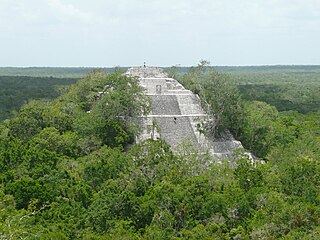
Quiriguá is an ancient Maya archaeological site in the department of Izabal in south-eastern Guatemala. It is a medium-sized site covering approximately 3 square kilometres (1.2 sq mi) along the lower Motagua River, with the ceremonial center about 1 km (0.6 mi) from the north bank. During the Maya Classic Period (AD 200–900), Quiriguá was situated at the juncture of several important trade routes. The site was occupied by 200, construction on the acropolis had begun by about 550, and an explosion of grander construction started in the 8th century. All construction had halted by about 850, except for a brief period of reoccupation in the Early Postclassic. Quiriguá shares its architectural and sculptural styles with the nearby Classic Period city of Copán, with whose history it is closely entwined.

Kʼinich Yax Kʼukʼ Moʼ

Kʼinich Yax Kʼukʼ Moʼ is named in Maya inscriptions as the founder and first ruler, kʼul ajaw, of the pre-Columbian Maya civilization polity centered at Copán, a major Maya site located in the southeastern Maya lowlands region in present-day Honduras. The motifs associated with his depiction on Copán monuments have a distinct resemblance to imagery associated with the height of the Classic-era center of Teotihuacan in the distant northern central Mexican region, and have been interpreted as intending to suggest his origins and association with that prestigious civilization. One of the most commonly cited motifs for this interpretation is the "goggle-eyed" headdress with which Yax Kʼukʼ Moʼ is commonly depicted; this is seemingly an allusion to the northern central Mexican rain deity known as Tlaloc by later peoples, such as the Aztecs. However, modern strontium isotope analysis of the human remains recovered from the tomb attributed to him indicate that Kʼinich Yax Kʼukʼ Moʼ spent his formative years much closer to Copán, at Tikal, and had not himself lived at Teotihuacan.

Kʼakʼ Tiliw Chan Yopaat King of Quirigua

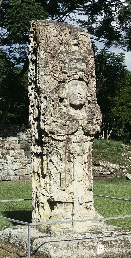
Kʼakʼ Tiliw Chan Yopaat, previously known variously as Cauac Sky, Kawak Sky, Butsʼ Tiliw and Butzʼ Tiʼliw, was the greatest leader of the ancient Maya city-state of Quiriguá.

Yikʼin Chan Kʼawiil Ruler of Tikal

Yikʼin Chan Kʼawiil also known as Ruler B, Yaxkin Caan Chac and Sun Sky Rain,, was an ajaw of the Maya city of Tikal. He took the throne on December 8, 734.

Chan Chak Kʼakʼnal Ajaw

Kʼahkʼ Pulaj Chan Chaahk, also known as Lord Chac before the decipherment of his corresponding name glyphs, is currently the only archaeologically identified ruler of the pre-Columbian Maya polity at Uxmal, who ruled in the early 10th century. Only a handful of details are known from this king, as hieroglyphic inscriptions, while very prominent in the Southern Maya Lowlands, are scarce in the north. What is known is that Lord Chac acceded to the throne somewhere at the end of the 9th century. During his rule, between 890-910 AD, some of the largest and most impressive buildings in Uxmal, such as the so-called Nunnery Quadrangle and the Governor's Palace, were built. An inscription at a large ballcourt in Uxmal, for playing the Mesoamerican ballgame, informs us it was dedicated in 901 during the reign of this king.

Women rulers in Maya society

During the 7th and 8th centuries in Mesoamerica, there was an evident shift in the roles women played in ancient Maya society as compared with the previous two centuries. It was during this time that there was a great deal of political complexity seen both in Maya royal houses as well as in the Maya area. Warfare was a significant factor in political competition and marriage was one of the ways that alliances were made between the different polities. This was accompanied by a shift in women's roles from wife and mother to playing integral parts in courtly life, such as participating in rituals involving the supernatural world and at times ruling individual polities.

Bʼalaj Chan Kʼawiil King of Dos Pilas

Bʼalaj Chan Kʼawiil was a Maya ruler of Dos Pilas. He is also known as Ruler 1, Flint Sky God K and Malah Chan Kʼawil.

Maya stelae Intricately carved stone slabs made by the Pre-Columbian Maya

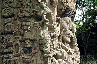
Maya stelae are monuments that were fashioned by the Maya civilization of ancient Mesoamerica. They consist of tall, sculpted stone shafts and are often associated with low circular stones referred to as altars, although their actual function is uncertain. Many stelae were sculpted in low relief, although plain monuments are found throughout the Maya region. The sculpting of these monuments spread throughout the Maya area during the Classic Period, and these pairings of sculpted stelae and circular altars are considered a hallmark of Classic Maya civilization. The earliest dated stela to have been found in situ in the Maya lowlands was recovered from the great city of Tikal in Guatemala. During the Classic Period almost every Maya kingdom in the southern lowlands raised stelae in its ceremonial centre.

Yuknoom Yichʼaak Kʼahkʼ King of Kaan

Yuknoom Yichʼaak Kʼahkʼ ) or Yuknoom Ixquiac was a Maya king of the Kaan kingdom, which had its capital at Calakmul during the Classic Period of Mesoamerican chronology.

Bolon Kʼawiil II

Bolon Kʼawiil II was a Maya king of Calakmul (>771-789?>). His monuments are Stelae 57 and 58 in his city.

Kʼakʼ Chan Yopaat

Kʼakʼ Chan Yopaat was the eleventh dynastic ruler at Copán. He was crowned as king in AD 578, 24 days after the death of Tzi-Bʼalam. At the time of his rule Copán was undergoing an unprecedented rise in population, with residential land use spreading to all available land in the entire Copán Valley. The two surviving stelae of Kʼakʼ Chan Yopaat contain long hard-to-decipher hieroglyphic texts and are the oldest monuments at the site to survive without being either broken or buried. He had a long reign, ruling at Copán for 49 years, and he died on 5 February 628. His name is recorded on four stelae erected by his successors, one of which describes a rite performed with relics from his tomb in AD 730, almost a hundred years after his death.

Chan Imix Kʼawiil was the twelfth ruler of the Maya city state Copán. His nickname was Smoke Jaguar.

Kʼakʼ Joplaj Chan Kʼawiil was installed as the 14th dynastic ruler of Copán on 7 June 738, 39 days after the execution of Uaxaclajuun Ubʼaah Kʼawiil. Little is known of his reign due to the lack of monuments raised after Quiriguá's surprise victory. Copán's defeat had wider implications due to the fracturing of the city's domain and the loss of the key Motagua River trade route to Quiriguá. The fall in Copán's income and corresponding increase at Quiriguá is evident from the massive commissioning of new monuments and architecture at the latter city and Copán may even have been subject to its former vassal. Kʼakʼ Joplaj Chan Kʼawiil died in January 749.

Kʼakʼ Yipyaj Chan Kʼawiil

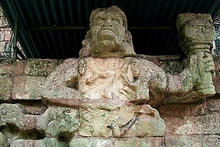
Kʼakʼ Yipyaj Chan Kʼawiil was a ruler of the Mayan city of Copán. He was the son of Kʼakʼ Joplaj Chan Kʼawiil. The early period of his rulership fell within Copán's hiatus but later on he began a programme of renewal in an effort to recover from the earlier disaster of the city. He built a new version of Temple 26, with the Hieroglyphic Stairway being reinstalled on the new stairway and doubled in length. Five life-size statues of seated rulers were installed seated upon the stairway. Kʼakʼ Yipyaj Chan Kʼawiil died in the early 760s and is likely to have been interred in Temple 11, although the tomb has not yet been excavated.

Third Tikal–Calakmul War

The Third Tikal–Calakmul War was the third in a series of wars between Tikal and Calakmul, two of the Major superpowers of the Maya Civilization during the classic period.

Tikal–Calakmul wars

The Tikal–Calakmul wars were a series of wars, mainly between Tikal and Calakmul on the Yucatán Peninsula, but also with vassal states in the Petén Basin such as Copan, Dos Pilas, Naranjo, Sacul, Quiriguá, and briefly Yaxchilan had a role in initiating the first war.

History of the Maya civilization

The history of Maya civilization is divided into three principal periods: the Preclassic, Classic and Postclassic periods; these were preceded by the Archaic Period, which saw the first settled villages and early developments in agriculture. Modern scholars regard these periods as arbitrary divisions of chronology of the Maya civilization, rather than indicative of cultural evolution or decadence. Definitions of the start and end dates of period spans can vary by as much as a century, depending on the author. The Preclassic lasted from approximately 2000 BC to approximately 250 AD; this was followed by the Classic, from 250 AD to roughly 950 AD, then by the Postclassic, from 950 AD to the middle of the 16th century. Each period is further subdivided:

References

Coe, Michael D. (1999). The Maya. Ancient peoples and places series (6th edition, fully revised and expanded ed.). London and New York: Thames & Hudson. ISBN   0-500-28066-5. OCLC   59432778.
Fash, William L. (2001). Scribes, Warriors, and Kings (Revised ed.). London.: Thames and Hudson. ISBN   0-500-28282-X.
Martin, Simon; Nikolai Grube (2000). Chronicle of the Maya Kings and Queens: Deciphering the Dynasties of the Ancient Maya. London and New York: Thames & Hudson. ISBN   0-500-05103-8. OCLC   47358325.
Martin, Simon; Nikolai Grube (2008). Chronicle of the Maya Kings and Queens (2nd ed.). New York, NY: Thames and Hudson. ISBN   9780500287262.
Sharer, Robert J.; Loa P. Traxler (2006). The Ancient Maya (6th (fully revised) ed.). Stanford, CA: Stanford University Press. ISBN   0-8047-4817-9. OCLC   57577446.
Schele, Linda; David Freidel (1990). A Forest of Kings (First ed.). New York, NY: William Morrow and Company, Inc. ISBN   0-688-07456-1.
Stuart, David (1996). "Hieroglyphs and History at Copán". Peabody Museum of Archaeology and Ethnology. Archived from the original on 2008-12-16. Retrieved 2011-01-19.