
The Matterhorn is a mountain of the Alps, straddling the main watershed and border between Italy and Switzerland. It is a large, near-symmetric pyramidal peak in the extended Monte Rosa area of the Pennine Alps, whose summit is 4,478 metres (14,692 ft) above sea level, making it one of the highest summits in the Alps and Europe. The four steep faces, rising above the surrounding glaciers, face the four compass points and are split by the Hörnli, Furggen, Leone/Lion, and Zmutt ridges. The mountain overlooks the Swiss town of Zermatt, in the canton of Valais, to the northeast; and the Italian town of Breuil-Cervinia in the Aosta Valley to the south. Just east of the Matterhorn is Theodul Pass, the main passage between the two valleys on its north and south sides, which has been a trade route since the Roman Era.

Alexander Huber is a German rock climber who is considered one of the greatest and most influential climbers in the history of rock climbing. Huber came to prominence in the early 1990s as the world's strongest sport climber after the passing of Wolfgang Güllich. He is the second-ever person to redpoint a 9a (5.14d) graded route by ascending Om in 1992, and has come to be known as the first-ever person to redpoint a 9a+ (5.15a) graded route from his 1996 ascent of Open Air.
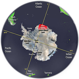
New Swabia was an area of Antarctica explored and briefly claimed by Nazi Germany within the Norwegian territorial claim of Queen Maud Land in early 1939. The region was named after the expedition's ship, Schwabenland, itself named after the German region of Swabia. Although the name "New Swabia" is occasionally mentioned in historical contexts, it is not an officially recognized cartographic name in modern use. The area is now part of Queen Maud Land, governed under the Antarctic Treaty System.

The Trango Towers are a family of rock towers situated in the Gilgit-Baltistan region, in the northern part of Pakistan. The Towers have some of the world's largest cliffs and offer some of the most challenging big wall climbing opportunities. Each year, climbers from around the world embark on expeditions to the Karakoram region to climb these granite faces. The Trango Towers are situated to the north of the Baltoro Glacier and are part of the Baltoro Muztagh, which is a sub-range within the Karakoram mountain range. The highest point within the group is the summit of Great Trango Tower at 6,286 m (20,623 ft), the east face of which features the world's greatest nearly vertical drop.

Lyaskovets Peak is the easternmost peak of Friesland Ridge in the Tangra Mountains, eastern Livingston Island and has an elevation of 1,473 m. The peak is bounded by Catalunyan Saddle on the west and Shipka Saddle on the east, and is heavily glaciated and crevassed, with precipitous western, southern and eastern slopes. It surmounts Huron Glacier to the northwest and northeast, and Macy Glacier and Brunow Bay area to the south. Its northern offshoot forms Zograf Peak, and is linked to Lozen Nunatak, Erma Knoll and Aheloy Nunatak in Huron Glacier.

Melnik Peak is the 696 m summit of Melnik Ridge in eastern Livingston Island, South Shetland Islands in Antarctica. Surmounting Kaliakra Glacier to the north and west, and Struma Glacier to the southeast. The peak takes its name from Melnik Ridge.

Tangra Mountains form the principal mountain range of Livingston Island in the South Shetland Islands, Antarctica. The range had been nameless until 2001, when it was named after Tengri, "the name of the ancient Bulgarian god."

Vidin Heights are predominantly ice-covered heights rising to 604 m (1,982 ft) on Varna Peninsula, eastern Livingston Island in the South Shetland Islands, Antarctica. The feature is approximately 8 m (26 ft) long from the north end of Leslie Gap east-northeastwards to Inott Point and 9.6 m (31 ft) north-northeastwards to Sayer Nunatak.

Camp Academia is a geographical locality in eastern Livingston Island, South Shetland Islands, Antarctica, named for the Bulgarian Academy of Sciences in appreciation of the Academy’s contribution to Antarctic exploration. The site was first occupied in the 2004/05 austral summer, and has been designated since 2004 as the summer post office Tangra 1091, the southernmost branch of the Bulgarian Posts Plc.

Thomas Huber is a German rock climber and mountaineer. He lives in Berchtesgaden with his family. His brother and regular climbing partner is Alexander Huber, and the two are called "Huberbuam" (Huberboys) in the Bavarian dialect; they were the subject of the 2007 film To the Limit. In 2001, Huber won the 10th Piolet d'Or award with Iwan Wolf for their ascent of the direct north pillar of Shivling.

Conrad Anker is an American rock climber, mountaineer, and author. He was the team leader of The North Face climbing team for 26 years until 2018. In 1999, he located George Mallory's body on Everest as a member of a search team looking for the remains of the British climber who was last seen in 1924. Anker had a heart attack in 2016 during an attempted ascent of Lunag Ri with David Lama. He was flown via helicopter to Kathmandu where he underwent emergency coronary angioplasty with a stent placed in his proximal left anterior descending artery. Afterwards he retired from high altitude mountaineering, but otherwise he continues his work. He lives in Bozeman, Montana.

The Tangra 2004/05 Expedition was commissioned by the Antarctic Place-names Commission at the Ministry of Foreign Affairs of Bulgaria, managed by the Manfred Wörner Foundation, and supported by the Bulgarian Antarctic Institute, the Institute of Mathematics and Informatics at the Bulgarian Academy of Sciences, Bulgarian Posts, Uruguayan Antarctic Institute, Peregrine Shipping (Australia), and Petrol Ltd, TNT, Mtel, Bulstrad, Polytours, B. Bekyarov and B. Chernev (Bulgaria).

The Scott Glacier is a major glacier, 120 nautical miles long, that drains the East Antarctic Ice Sheet through the Queen Maud Mountains to the Ross Ice Shelf. The Scott Glacier is one of a series of major glaciers flowing across the Transantarctic Mountains, with the Amundsen Glacier to the west and the Leverett and Reedy glaciers to the east.
The Hays Mountains are a large group of mountains and peaks of the Queen Maud Mountains of Antarctica, surmounting the divide between the lower portions of Amundsen Glacier and Scott Glacier and extending from the vicinity of Mount Thorne on the northwest to Mount Dietz on the southeast.
Istind Peak is a partly ice-covered peak 1.5 km (1 mi) south of Tindeklypa, on the east side of Ahlmann Ridge in Queen Maud Land, Antarctica. It was photographed from the air by the Third German Antarctic Expedition (1938–39). It was mapped by Norwegian cartographers from air photos by the Norwegian–British–Swedish Antarctic Expedition (1949–1952), led by John Schjelderup Giæver, and from air photos by the Norwegian expedition (1958–59) and named "Istind".

Jøkulkyrkja Mountain, also known as Massiv Yakova Gakkelya, is a broad, ice-topped mountain with several radial rock spurs, standing east of Lunde Glacier in the Mühlig-Hofmann Mountains of Queen Maud Land, East Antarctica. At 3,148 metres (10,328 ft) elevation, it is the highest mountain in Queen Maud Land, and also the highest rock elevation within the claims of Norway. However, Dome F is also located in Queen Maud Land, and rises to about 3,700 metres (12,100 ft). The mountain is located on the Princess Astrid Coast of the Norwegian Antarctic Territory. Håhellerskarvet, 2,910 metres (9,550 ft), is located to the southwest; the two peaks are separated by the 25-mile-long Lunde Glacier, which flows to the northwest.

Queen Maud Land is a roughly 2.7-million-square-kilometre (1.0-million-square-mile) region of Antarctica claimed by Norway as a dependent territory. It borders the claimed British Antarctic Territory 20° west and the Australian Antarctic Territory 45° east. In addition, a small unclaimed area from 1939 was annexed in June 2015. Positioned in East Antarctica, it makes out about one-fifth of the continent, and is named after the Norwegian Queen Maud (1869–1938).

The Gjelsvik Mountains are a group of mountains about 25 nautical miles (50 km) long, between the Sverdrup Mountains and the Mühlig-Hofmann Mountains in Queen Maud Land, East Antarctica. With its summit at 2,705 metres (8,875 ft), the massive Risemedet Mountain forms the highest point in these mountains, also marking their eastern end.

Alain Hubert is a Belgian explorer. He is a certified mountain and polar guide, a civil engineer, and the founder President of the International Polar Foundation. With the Foundation and its private partners, he built and financed the construction of the scientific research station ‘Princess Elisabeth’. This station is the first ‘Zero Emissions’ station in Antarctica, designed under the spirit of the Madrid protocol system establishing in 1992 the strictest environmental rules to date for a continent through the Antarctic Treaty System.

