Umivik Bay

Last updated
Umivik Bay
Umivik Bugt - SE coast-Greenland-pclmaps-oclc-8322829 c 13.jpg
Map of Greenland section showing Umivik Bay
Greenland edcp relief location map.jpg
Red pog.svg
Umivik Bay
Location in Greenland
Location Arctic
Coordinates 64°14′N40°36′W / 64.233°N 40.600°W / 64.233; -40.600 Coordinates: 64°14′N40°36′W / 64.233°N 40.600°W / 64.233; -40.600
Native nameUmivik Bugt  (Danish)
Ocean/sea sources North Atlantic Ocean
Basin  countries Greenland
Max. length50 km (31 mi)
Max. width25 km (16 mi)

Umivik Bay (Danish : Umivik Bugt), also known as Umiivik and Umerik, is a bay in King Frederick VI Coast, southeastern Greenland. It is part of the Sermersooq municipality.

Contents

Unlike the jagged and forbidding appearance of most fjord systems in East Greenland, the Umivik area has a relatively gentle shape. Here the massive Greenland ice sheet comes down to the shore in smooth, even undulations and the landscape looks unbroken, with only few glimpses of bare rock. [1] Owing to this smoothness, Umivik Bay was chosen as launching point for westward overland crossings, including the pioneering 1888 Greenland venture by Fridtjof Nansen.

Geography

Umivik Bay
Umivik Bay

Umivik Bay is located between the Fridtjof Nansen Peninsula to the north and the Odinland Peninsula to the south. It includes a sound and a fjord and has a few large islands, the largest of which is Upernattivik (Upernarsuak) lying squarely in the middle of the inner part of the bay. Other significant islands in the bay are Trefoldigheden, Terne Island and Tre Lover in the inner bay, as well as Pikiitsi further east off the shore. The innermost part of the bay, by the terminus of the glaciers is known as Qíngua. [2]

The northern side of the bay includes three sounds, the Dietrichson Sound between Trefoldigheden and the mainland, the Torsukattak Sound between Upernattivik and the mainland —both about 800 metres (2,625 feet) wide, and the Sverdrup Sound between both islands. At the bay's northeastern end there is the small Jensen Bay, as well as numerous islets and rocks with intricate channels.

Umiiviip Kangertiva (Gyldenløve Fjord), was named after Hans Ulrik Gyldenløve by Lieutenant W. A. Graah in 1829. It is located on the southern side of the bay, between Upernattivik and the mainland shore; Vikingevig is a small bay in the fjord, in the northern shore of Odinland. Umivik Bay's mouth is located between Cape Colberger Heide and Cape Lovelorn in the Denmark Strait area of the Atlantic Ocean. [2]

Glacier terminus at Umiiviip Kangertiva (Gyldenlove Fjord). Gyldenlove Glacier (5610836462).jpg
Glacier terminus at Umiiviip Kangertiva (Gyldenløve Fjord).
Nansen's 1888 route across Greenland showing Sermilik and Umivik in the east coast. Nansen Greenland Crossing Map af.png
Nansen's 1888 route across Greenland showing Sermilik and Umivik in the east coast.

History

There are two Paleo-Eskimo archaeological sites near the entrance to Umivik Bay on the northeastern side; one on the mainland shore and the other in the Garner Islands. [3]

Until recent times Inuit visited the area during hunting trips. Fridjof Nansen wrote:

...as soon as the Eskimos come to a place where there are plenty of seals, they go ashore, pitch their camp, take to hunting, and live at their ease. When the autumn and winter approach, they choose a good site and build a winter-house, continuing their journey in the spring or summer as soon as the ice permits. The woman-boat in question had in this manner spent three years on the passage from Umivik, and would no doubt take pretty nearly as long to return. [4]

Nansen's expedition left sealer Jason near Sermilik Fjord, where Nansen had initially decided to start the crossing. [5] However, there followed days of extreme frustration for the party as, prevented by weather and sea conditions from reaching the shore, they drifted southwards with the ice. Most of this time was spent camping on the ice itself—it was too dangerous to launch the boats. By 29 July they were 380 kilometres (240 mi) south of the point where they had left the ship. On that day they finally reached land, but were too far south to begin the crossing. After a brief rest, Nansen ordered the team back into the boats and to begin rowing north. [6]

During the next 12 days the party battled northward along the coast through the ice floes. On the first day they encountered a large Eskimo encampment near Cape Steen Bille, [7] and there were further occasional contacts with the nomadic native population as the journey continued. On 11 August, when they had covered about 200 kilometres (120 mi) and had reached Umivik Bay, Nansen decided that although they were still far south of his intended starting place, they needed to begin the crossing before the season became too advanced for travel. [8] After landing at Umivik, they spent the next four days preparing for their journey, and on the evening of 15 August they set out. They were heading north-west, towards Christianhaab (now Qasigiannguit) on the west Greenland shores of Disko Bay, 600 kilometres (370 mi) away. [9]

View of Umivik Bay and its promontory No-nb bldsa 3b161.jpg
View of Umivik Bay and its promontory
Umivik Bay. The last sailing before the members of Nansen's expedition began their skiing journey across the inland ice. No-nb bldsa 3b044.jpg
Umivik Bay. The last sailing before the members of Nansen's expedition began their skiing journey across the inland ice.
Picture of Umivik Bay by Nansen's expedition No-nb bldsa 3b032.jpg
Picture of Umivik Bay by Nansen's expedition

See also

Bibliography

Related Research Articles

Fridtjof Nansen Norwegian polar explorer (1861–1930)

Fridtjof Wedel-Jarlsberg Nansen was a Norwegian polymath and Nobel Peace Prize laureate. He gained prominence at various points in his life as an explorer, scientist, diplomat and humanitarian. He led the team that made the first crossing of the Greenland interior in 1888, traversing the island on cross-country skis. He won international fame after reaching a record northern latitude of 86°14′ during his Fram expedition of 1893—1896. Although he retired from exploration after his return to Norway, his techniques of polar travel and his innovations in equipment and clothing influenced a generation of subsequent Arctic and Antarctic expeditions.

Count Eigil Knuth was a Danish explorer, archaeologist, sculptor and writer. He is referred to as the Nestor of Danish polar explorers. His archaeological investigations were made in Peary Land and adjacent areas of High Arctic Greenland. Knuth was made a Knight of the Dannebrog.

Nansens <i>Fram</i> expedition 1893–1896 attempt by Fridtjof Nansen to reach the North Pole

Nansen's Fram expedition of 1893–1896 was an attempt by the Norwegian explorer Fridtjof Nansen to reach the geographical North Pole by harnessing the natural east–west current of the Arctic Ocean. In the face of much discouragement from other polar explorers, Nansen took his ship Fram to the New Siberian Islands in the eastern Arctic Ocean, froze her into the pack ice, and waited for the drift to carry her towards the pole. Impatient with the slow speed and erratic character of the drift, after 18 months Nansen and a chosen companion, Hjalmar Johansen, left the ship with a team of Samoyed dogs and sledges and made for the pole. They did not reach it, but they achieved a record Farthest North latitude of 86°13.6′N before a long retreat over ice and water to reach safety in Franz Josef Land. Meanwhile, Fram continued to drift westward, finally emerging in the North Atlantic Ocean.

Peder Olsen Walløe

Peder Olsen Walløe was a Dano-Norwegian Arctic explorer most noted for his historic exploration of the former Norse settlements on Greenland.

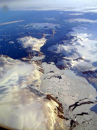
Søren Norby Islands, named after Søren Norby, is an uninhabited archipelago close to the shores of Eastern Greenland. Administratively it is part of the Sermersooq municipality.

Skjoldungen

Skjoldungen is a large uninhabited island in the King Frederick VI Coast, southeastern Greenland. Administratively it is part of the Sermersooq municipality. The weather of the island is characterized by tundra climate.

Upernattivik – also known as Upernarsuak – is an uninhabited island in King Frederick VI Coast, southeastern Greenland. Administratively it is part of the Sermersooq municipality.

Bernstorff Fjord Body of water

Bernstorff Fjord is a fjord in King Frederick VI Coast, eastern Greenland.

Sermilik Body of water

Sermilik is a fjord in eastern Greenland. It is part of the Sermersooq municipality.

Nanuuseq, also known as Nanûseq or Nanusek is an uninhabited island in the Kujalleq municipality in southern Greenland.

Lindenow Fjord or Kangerlussuatsiaq, is a fjord in the King Frederick VI Coast, Kujalleq municipality, southern Greenland.

King Frederick VI Coast Region in Greenland

King Frederick VI Coast is a major geographic division of Greenland. It comprises the coastal area of Southeastern Greenland in Sermersooq and Kujalleq municipalities fronting the Irminger Sea of the North Atlantic Ocean. It is bordered by King Christian IX Land on the north and the Greenland Ice Sheet to the west.

Pikiulleq is a bay in eastern Greenland. It is part of the Sermersooq municipality.

Odinland Peninsula in southeastern Greenland

Odinland, also Odinsland in the Defense Mapping Agency Greenland Navigation charts, is a peninsula in the King Frederick VI Coast, southeastern Greenland. It is a part of the Sermersooq municipality.

De Long Fjord is a fjord system in Peary Land, northern Greenland. To the northwest, the fjord opens into the Lincoln Sea of the Arctic Ocean. It is part of the Northeast Greenland National Park.

Griffenfeld Island, Griffenfeldt Island, or Umanaq, after the name of the highest peak. is an uninhabited island in the Sermersooq municipality in southern Greenland.

Dijmphna Sound Strait in Greenland

The Dijmphna Sound is a sound in King Frederick VIII Land, Northeast Greenland. Administratively it is part of the Northeast Greenland National Park zone.

Nansen Land is a peninsula in far northwestern Greenland. It is a part of the Northeast Greenland National Park.

Jens Munk Island, uninhabited coastal island in eastern Greenland in the Sermersooq municipality. It is named after the Dano-Norwegian navigator and explorer Jens Munk. The island is the largest in the Søren Norby Islands archipelago.

Fridtjof Nansen Peninsula

Fridtjof Nansen Peninsula is a peninsula in the King Frederick VI Coast, southeastern Greenland. It is a part of the Sermersooq municipality.

References

  1. Prostar Sailing Directions 2005 Greenland and Iceland Enroute, p. 102
  2. 1 2 "Umiivik". Mapcarta. Retrieved 11 April 2016.
  3. "Distribution Map of Archaeological, Historic, Cultural and Ancient Sites sites in Greenland" . Retrieved 15 April 2016.
  4. Fridtjof Nansen, Eskimo Life, p. 86
  5. Huntford, pp. 97–99
  6. Reynolds, pp. 48–52
  7. Huntford, pp. 105–110
  8. Scott, p. 84
  9. Huntford, pp. 115–116