Adams County is a county located in the U.S. state of Mississippi. As of the 2020 census, the population was 29,538. The county seat is Natchez. The county is the first to have been organized in the former Mississippi Territory. It is named for the second President of the United States, John Adams, who held that office when the county was organized in 1799. Adams County is part of the Natchez micropolitan area which consists of Adams County, Mississippi and Concordia Parish, Louisiana.

Lee County is a county in U.S. state of Mississippi. At the 2020 census, the population was 83,343. Its county seat is Tupelo. Lee County is included in the Tupelo Micropolitan Statistical Area.

Jefferson County is a county located in the U.S. state of Mississippi; its western border is formed by the Mississippi River. As of the 2020 census, the population was 7,260, making it the fourth-least populous county in Mississippi. Its first county seat was located at Old Greenville until 1825, which no longer exists, before moving to Fayette. The county is named for U.S. President Thomas Jefferson. One of the first of two counties organized in the Mississippi Territory in 1798 along with Adams County, it was first named Pickering County and included what would become Claiborne County. Originally developed as cotton plantations in the antebellum era, the rural county has struggled with a declining economy and reduced population since the mechanization of agriculture and urbanization of other areas. In 2020, its population of 7,260 was roughly one-third of the population peak in 1900. Within the United States, in 2009 rural Jefferson County had the highest percentage of African-Americans of any county. It was the fourth-poorest county in the nation.

Natchez is the only city in and the county seat of Adams County, Mississippi, United States. The population was 14,520 at the 2020 census. Located on the Mississippi River across from Vidalia, Louisiana, Natchez was a prominent city in the antebellum years, a center of cotton planters and Mississippi River trade.

The Natchez Trace, also known as the Old Natchez Trace, is a historic forest trail within the United States which extends roughly 440 miles (710 km) from Nashville, Tennessee, to Natchez, Mississippi, linking the Cumberland, Tennessee, and Mississippi rivers.

The Natchez Trace Parkway is a limited-access national parkway in the Southeastern United States that commemorates the historic Natchez Trace and preserves sections of that original trail. Its central feature is a two-lane road that extends 444 miles (715 km) from Natchez, Mississippi, to Nashville, Tennessee. Access to the parkway is limited, with more than 50 access points in Mississippi, Alabama, and Tennessee. The southern end of the route is in Natchez at its intersection with Liberty Road, and the northern end is northeast of Fairview, Tennessee, in the suburban community of Pasquo, at an intersection with Tennessee State Route 100. In addition to Natchez and Nashville, larger cities along the route include Jackson and Tupelo, Mississippi, and Florence, Alabama.

Rodney is a ghost town in Jefferson County, Mississippi, United States. Most of the buildings are gone and the remaining structures are in various states of disrepair. The town regularly floods and buildings have extensive flood damage. The Rodney History And Preservation Society is restoring Rodney Presbyterian Church, whose damaged facade from the American Civil War that includes a replica cannonball embedded above its balcony windows, has been maintained as part of the historical preservation. The Rodney Center Historic District is on the National Register of Historic Places.

The Elizabeth Female Academy, founded in 1818 in the town of Washington, was the first female educational institution in Mississippi. It was named after Mrs. Elizabeth Roach, who donated the land on which the school was located.

Seven segments of the historic Natchez Trace are listed on the National Register of Historic Places (NRHP). Also there are additional NRHP-listed structures and other sites along the Natchez Trace, which served the travelers of the trace and survive from the era of its active use.

Rocky Springs is a ghost town and historic site located in Claiborne County, Mississippi, United States, between Old Port Gibson Road and the Natchez Trace Parkway. The old town site can be viewed by the public during daylight hours. Rocky Springs and the surrounding area is maintained by the National Park Service.

Silas Dinsmoor was an appointed U.S. Agent to the Cherokee (1794–1798) and to the Choctaw (1801–1813). He later served as a surveyor in Alabama before eventually retiring to Boone County, Kentucky, where he is buried at the Dinsmore Homestead.

Coon Box, also Coonbox and Raccoon Box, is a placename in Jefferson County, Mississippi, United States. Coon Box is 5.9 miles (9.5 km) north of Fayette. The Coon Box Fork Bridge, which is listed on the National Register of Historic Places, is located one mile southwest of Coon Box.

Selsertown is a ghost town in Adams County, Mississippi, United States.
Bruinsburg is an extinct settlement in Claiborne County, Mississippi, United States. Founded when the Natchez District was part of West Florida, the settlement was one of the end points of the Natchez Trace land route from Nashville to the lower Mississippi River valley.

Pigeon Roost is a ghost town in Choctaw County, Mississippi.

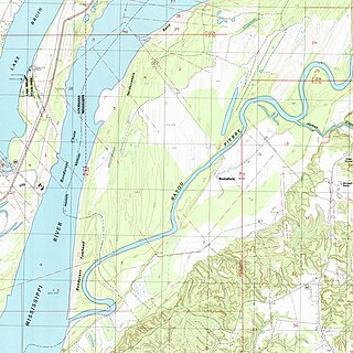
Old Greenville is a ghost town in Jefferson County, Mississippi, United States. The town was located along the old Natchez Trace and was once the largest town along the Trace. Nothing exists at the site today except the town's cemetery.

The circumstances of the end of Rachel Donelson's relationship with Lewis Robards and transition to Andrew Jackson resurfaced as a campaign issue in the 1828 U.S. presidential election. As Frances Clifton put it in her study of Jackson's long friendship with John Overton, "Jackson's irregular marriage proved good propaganda for the friends of Adams and Clay. The political enemies of Jackson 'saw in his wife a weak spot in his armor through which his vitals might be reached; and they did not hesitate to make the most of it.'"

Shankstown, Mississippi is an extinct settlement that was located two miles northeast of Coonbox and six miles north of Old Greenville in Jefferson County, Mississippi. Shankstown stood along the Natchez Trace. Shankstown was established by tavern keeper John H. Shanks around 1810, and that town was originally incorporated as Louisville, Mississippi in 1825, but was still commonly called Shankstown. The settlement had a U.S. post office and a number of businesses in the first half of the 19th century. There was a stagecoach route between Port Gibson and Natchez that stopped at Shankstown three times a week.

Saint Catherine Creek is a stream in Adams County, Mississippi, United States. Its principal drainage basin is in the vicinity of Natchez, Mississippi. The main village of the Natchez people was located on St. Catherine's Creek. The first plantation in the Natchez district was established in 1718, during the French colonial era, along St. Catherine's Creek. The second capital of Mississippi Territory, Washington, could be reached by St. Catherine's Creek, in seasons of high water. Circa 1808, water for the village at Washington was said to be "well supplied by wells about forty feet deep, and about a quarter of a mile from the east end is a delightful spring, near the bank of St. Catherine's creek, where is a hot and cold bath — the price of bathing is three eighths of a dollar."

Fort Dearborn, also known as Washington Cantonment, was a U.S. Army base in Mississippi Territory on the Natchez Trace in Adams County near the territorial capital of Washington. Established in 1802 or 1803, the fort was used as a base during the War of 1812.