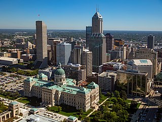
Indianapolis, colloquially known as Indy, is the capital and most populous city of the U.S. state of Indiana and the seat of Marion County. Indianapolis is situated in the state's central till plain region along the west fork of the White River. The city's official slogan, "Crossroads of America", reflects its historic importance as a transportation hub and its relative proximity to other major North American markets.

Greenwood is a city in Johnson County, Indiana, United States. The population was 63,830 at the 2020 Census. Greenwood is located southeast of central Indianapolis between Indiana State Road 37 and Interstate 65. The city shares a border with Indianapolis and is the most populous suburban municipality in the southern portion of the Indianapolis Metropolitan Area.

Indiana University–Purdue University Indianapolis (IUPUI) was a public research university in Indianapolis, Indiana, United States. It was a collaboration between Indiana University and Purdue University that offered undergraduate, graduate, and professional degrees from both universities. Administered primarily through Indiana University as a core campus and secondarily through Purdue University as a regional campus, it was Indiana's primary urban research and academic health sciences institution. IUPUI was located in downtown Indianapolis along the White River and Fall Creek.

The Purdue University system is a public university system in the U.S. state of Indiana. A land-grant university with nearly 75,000 students across three institutions comprising five physical campuses, a statewide technology program, extension centers in each of Indiana's 92 counties, and continuing education programs. Additionally, there are another ~44,000 students enrolled in an online university. Each university in the system maintains its own faculty and admissions policies which are overseen by the Purdue University Board of Trustees. Purdue's main campus in West Lafayette is the best-known, noted for its highly regarded programs in engineering and adjacent subjects.
Seminole Heights is a historic neighborhood and district located in central Tampa. It is bounded on the west by Florida Avenue, on the north by Hanna Avenue, on the east by Interstate 275 and on the south by Osborne Avenue. It includes many early 20th century bungalow homes and historic buildings. It was an early residential area of Tampa connected by streetcar. The area had an economic downturn in the late 20th century marked by increased crime, but has since seen a resurgence with new restaurants, brew pubs and independent businesses opening up. The neighborhood's historic homes, eclectic shops and gourmet restaurants are an increasing draw.

U.S. Route 12 (US 12) in the U.S. state of Illinois is an arterial highway that runs northwest to southeast through the Chicago metropolitan area. It enters Illinois at the Wisconsin border north of Richmond, and exits into Hammond, Indiana, from Chicago near the foot of the onramp to the Indiana Toll Road ; as it exits Illinois, the route is also concurrent with US 20 and US 41. Within Illinois, US 12 runs for a distance of 85.14 miles (137.02 km).
Seven neighborhoods in Indianapolis, Indiana, are designated as official Cultural Districts. These are Broad Ripple Village, Canal and White River State Park, Fountain Square, Indiana Avenue, Market East, Mass Ave, and the Wholesale District.
Downtown Indianapolis is a neighborhood area and the central business district of Indianapolis, Indiana, United States. Downtown is bordered by Interstate 65, Interstate 70, and the White River, and is situated near the geographic center of Marion County. Downtown has grown from the original 1821 town plat—often referred to as the Mile Square—to encompass a broader geographic area of central Indianapolis, containing several smaller historic neighborhoods.

Castleton is a neighborhood area in Lawrence and Washington townships on the northeast side of Indianapolis, Indiana, United States. After shortly over a century of being an independent town, the locality was included in Indianapolis as part of Unigov consolidation in 1970 and was further dissolved in 1992. It is a primarily commercial district today.
Columbus, the state capital and Ohio's largest city, has numerous neighborhoods within its city limits. Neighborhood names and boundaries are not officially defined. They may vary or change from time to time due to demographic and economic variables.

Fountain Square is one of seven designated cultural districts in Indianapolis, Indiana. Located just outside the city's downtown district, Fountain Square is home to three designated national historic districts, the Laurel and Prospect, the State and Prospect, and the Virginia Avenue districts, all of which were listed on the National Register of Historic Places in 1983. The neighborhood derives its name from the successive fountains that have been prominently featured at the intersection of Virginia Avenue, East Prospect Street, and Shelby Street.
The Indianapolis Public Transportation Corporation, branded as IndyGo, is a public transit agency and municipal corporation of the City of Indianapolis in the U.S. state of Indiana. It operates fixed-route buses, bus rapid transit, microtransit, and paratransit services.

Broad Ripple Village is one of seven areas designated as cultural districts in Indianapolis, Indiana. Located in Washington Township, Marion County, Indiana, about six miles north of downtown Indianapolis, Broad Ripple was first platted in 1837, became incorporated as the Town of Broad Ripple in 1894, and was annexed to the City of Indianapolis in 1922.
Transportation in Indianapolis consists of a complex network that includes a local public bus system, several private intercity bus providers, Amtrak passenger rail service, four freight rail lines, an Interstate Highway System, an airport, a heliport, bikeshare system, 115 miles (185 km) of bike lanes, and 116 miles (187 km) of trails and greenways. The city has also become known for its prevalence of electric scooters.
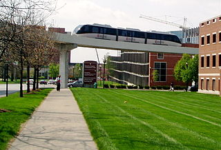
The Indiana University Health People Mover, formerly the Clarian Health People Mover, was a 1.4-mile (2.3 km) long, 4 ft narrow gauge people mover in the city of Indianapolis in the United States. The system opened on June 28, 2003, to connect Methodist Hospital of Indianapolis, Indiana University Hospital, and James Whitcomb Riley Hospital for Children, jointly operated as a single hospital by Indiana University Health.
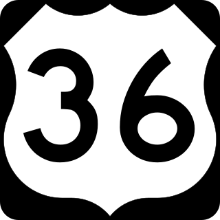
U.S. Route 36 is a part of the United States Numbered Highway System that runs from Rocky Mountain National Park, Colorado to Uhrichsville, Ohio. In the state of Indiana, it is part of the Indiana State Road system that runs across the central portion of the state from the Illinois state line near Dana to the Ohio state line near Spartanburg. In the Indianapolis area, US 36 overlaps the southern section of Interstate 465 (I-465), bypassing the downtown area where the route formerly went.

The Bethel A.M.E. Church, known in its early years as Indianapolis Station or the Vermont Street Church, is a historic African Methodist Episcopal Church in Indianapolis, Indiana. Organized in 1836, it is the city's oldest African-American congregation. The three-story church on West Vermont Street dates to 1869 and was added to the National Register in 1991. The surrounding neighborhood, once the heart of downtown Indianapolis's African American community, significantly changed with post-World War II urban development that included new hotels, apartments, office space, museums, and the Indiana University–Purdue University at Indianapolis campus. In 2016 the congregation sold their deteriorating church, which was repurposed into part of a new hotel. The congregation built a new worship center at 6417 Zionsville Road in Pike Township in northwest Indianapolis.

The Indianapolis Cultural Trail, officially the Indianapolis Cultural Trail: A Legacy of Gene & Marilyn Glick, is an 8.1-mile-long (13.0 km) urban shared-use path and linear park located in the vicinity of downtown Indianapolis, Indiana. The trail is often compared to other popular bicycle and pedestrian paths across the U.S. and has inspired similar projects throughout the U.S. and Canada.

The transportation system of Cleveland is a network that includes several modes of transportation including sidewalks, roads, public transit, bicycle paths and regional and international airports.

