
The Viceroyalty of the New Kingdom of Granada, also called Viceroyalty of New Granada or Viceroyalty of Santa Fe, was the name given on 27 May 1717 to the jurisdiction of the Spanish Empire in northern South America, corresponding to modern Colombia, Ecuador, Panama and Venezuela. Created in 1717 by King Felipe V, as part of a new territorial control policy, it was suspended in 1723 for financial problems and was restored in 1739 until the independence movement suspended it again in 1810. The territory corresponding to Panama was incorporated later in 1739, and the provinces of Venezuela were separated from the Viceroyalty and assigned to the Captaincy General of Venezuela in 1777. In addition to those core areas, the territory of the Viceroyalty of New Granada included Guyana, Trinidad and Tobago, southwestern Suriname, parts of northwestern Brazil, and northern Peru. A strip along the Atlantic Ocean in Mosquito Coast was added by the Royal Decree of 20 November 1803, but the British battled for administrative control.

Boyacá is one of the thirty-two departments of Colombia, and the remnant of Boyacá State, one of the original nine states of the "United States of Colombia".

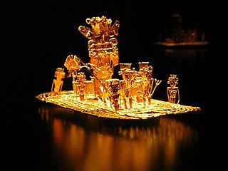
Gonzalo Jiménez de Quesada y Rivera, also spelled as Ximénez and De Quezada, was a Spanish explorer and conquistador in northern South America, territories currently known as Colombia. He explored the territory named by him New Kingdom of Granada, and founded its capital, Santafé de Bogotá. As a well-educated lawyer he was one of the intellectuals of the Spanish conquest. He was an effective organizer and leader, designed the first legislation for the government of the area, and was its historian. He was governor of Cartagena between 1556 and 1557, and after 1569 he undertook explorations toward the east, searching for the elusive El Dorado. The campaign didn't succeed and Jiménez then returned to New Granada in 1573. He has been suggested as a possible model for Cervantes' Don Quixote.
Guainía is a department of Eastern Colombia. It is in the east of the country, bordering Venezuela and Brazil. Its capital is Inírida. In 1963 Guainía was split off from Vaupés department. The northern part and the Inírida River are included in the Orinoco basin; the rest is part of the Amazon basin. The Guaviare River is the main area of colonization; many colonos come from the Colombian Andean zone, most of them from Boyacá. They are followed by the llaneros, people from the Eastern plains (Llanos). The population is mainly composed of Amerindians, and the largest ethnic groups are the Puinaves and the curripacos. There are a total of 24 ethnic groups in the department; many of them speak four Indigenous languages besides Spanish and Portuguese.

Meta is a department of Colombia. It is close to the geographic center of the country, to the east of the Andean mountains. A large portion of the department, which is also crossed by the Meta River, is covered by a grassland plain known as the Llanos. Its capital is Villavicencio. The department has a monument placed in the very geographic centre of Colombia, at a place known as Alto de Menegua, a few kilometers from Puerto López.

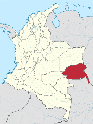
Vichada Department is a department of the Republic of Colombia in South America. Vichada is located in the eastern plains of Colombia, in the Orinoquía Region within the Orinoco river basin bordering the Bolivarian Republic of Venezuela to the north and east. To the north the department also borders with Arauca Department, to the northwest with Casanare Department, to the west with Meta Department, to the southwest narrowly bordering with Guaviare Department and to the south with Guainía Department. The department is the second largest in Colombia and scarcely populated in comparison to other departments.
The Venezuelan War of Independence was one of the Spanish American wars of independence of the early nineteenth century, when independence movements in South America fought a civil war for secession and against unity of the Spanish Empire, emboldened by Spain's troubles in the Napoleonic Wars.

Villavicencio is a city and municipality in Colombia. The capital of Meta Department, it was founded on April 6, 1840. The municipality had a population of 531,275 in 2018. The city is located at 4°08'N, 73°40'W, 75 km southeast of the Colombian capital city of Bogotá (DC) by the Guatiquía River. It is the most important commercial center in the Llanos Orientales of Colombia.
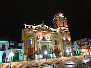
Tunja is a municipality and city on the Eastern Ranges of the Colombian Andes, in the region known as the Altiplano Cundiboyacense, 130 km northeast of Bogotá. In 2018 the municipality had a population of 172,548. It is the capital of Boyacá department and the Central Boyacá Province. Tunja is an important educational centre of well-known universities. In the time before the Spanish conquest of the Muisca, there was an indigenous settlement, called Hunza, seat of the hoa Eucaneme, conquered by the Spanish conquistadors on August 20, 1537. The Spanish city was founded by captain Gonzalo Suárez Rendón on August 6, 1539, exactly one year after the capital Santafé de Bogotá. The city hosts the most remaining Muisca architecture: Hunzahúa Well, Goranchacha Temple and Cojines del Zaque.

The Llanos is a vast tropical grassland plain situated to the east of the Andes in Colombia and Venezuela, in northwestern South America. It is an ecoregion of the tropical and subtropical grasslands, savannas, and shrublands biome.

The Meta River is a major left tributary of the Orinoco River in eastern Colombia and southern Venezuela, South America. The Meta originates in the Eastern Ranges of the Andes and flows through the Meta Department, Colombia as the confluence of the Humea, Guatiquía and Guayuriba rivers. It flows east-northeastward across the Llanos Orientales of Colombia following the direction of the Meta Fault. The Meta forms the northern boundary of Vichada Department, first with Casanare Department, then with Arauca Department, and finally with Venezuela, down to Puerto Carreño where it flows into the Orinoco.
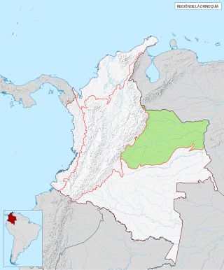
The Orinoquía region is one of the six natural regions of Colombia that belongs to the Orinoco River watershed. It's also known colloquially as the Eastern Plains from the Spanish Llanos Orientales. The region covers most of the area of the departments of Arauca, Casanare, Meta, and Vichada.

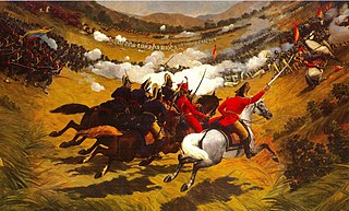
Vargas Swamp Lancers, or Monument to the Lancers, is a large sculptural complex realized by Colombian artist Rodrigo Arenas Betancourt and by engineer Guillermo Gonzalez Zuleta in the department of Boyacá (Colombia) as a memorial for the Battle of Vargas Swamp. It is the largest monument in Colombia.

Because of its natural structure, Colombia can be divided into six distinct natural regions. These consist of the Andean Region, covering the three branches of the Andes mountains found in Colombia; the Caribbean Region, covering the area adjacent to the Caribbean Sea; the Pacific Region adjacent to the Pacific Ocean; the Orinoquía Region, part of the Llanos plains mainly in the Orinoco river basin along the border with Venezuela; the Amazon Region, part of the Amazon rainforest; and finally the Insular Region, comprising the islands in both the Atlantic and Pacific Oceans. Colombia is located in South America.

Geology of Colombia refers to the geological composition of the Republic of Colombia that determines its geography. Most of the emerged territory of Colombia covers vast areas within the South American Plate, whereas much submerged territory lies within the Caribbean Plate and the Nazca Plate.
Libertadores del Vichada, was a Colombian drug trafficking neo-paramilitary group involved in the Colombian armed conflict. It is considered to be one of the most important drug trafficking organizations in eastern Colombia. The group is led by Martín Farfán Díaz González, alias 'Pijarbey,' a former leader of the neo-paramilitary group ERPAC. According to Colombia's prosecutor general, Díaz González is responsible for several homicides and acts of terrorism against the civilian population. The last leader of the criminal group was captured September 22, 2017, in Villavicencio (Meta). With this capture, according to statements by the Ministry of Defence, the organization is completely dismantled.

The Llanero Spanish is a variety of Spanish spoken in the Llanos region of Colombia and Venezuela. It is characterized by the mixing of elements from Old Spanish with indigenous elements.
Muisca cuisine describes the food and preparation the Muisca elaborated. The Muisca were an advanced civilization inhabiting the central highlands of the Colombian Andes before the Spanish conquest of the Muisca in the 1530s. Their diet and cuisine consisted of many endemic flora and fauna of Colombia.

The Tegua or Tecua were an Arawak-speaking indigenous people of Colombia who died out in the 19th century.

The Llanos Basin or Eastern Llanos Basin is a major sedimentary basin of 96,000 square kilometres (37,000 sq mi) in northeastern Colombia. The onshore foreland on Mesozoic rift basin covers the departments of Arauca, Casanare and Meta and parts of eastern Boyacá and Cundinamarca, western Guainía, northern Guaviare and southeasternmost Norte de Santander. The northern boundary is formed by the border with Venezuela, where the basin grades into the Barinas-Apure Basin.
