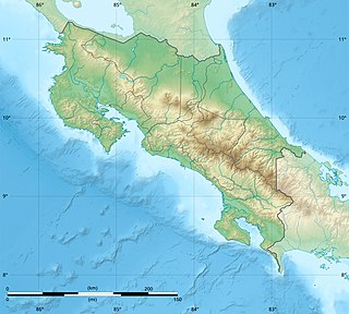
Upala Airport

Last updated
Upala Airport
Summary
Airport typePublic
Serves Upala, Costa Rica
Elevation  AMSL 184 ft / 56 m
Coordinates 10°53′30″N85°01′00″W / 10.89167°N 85.01667°W / 10.89167; -85.01667 Coordinates: 10°53′30″N85°01′00″W / 10.89167°N 85.01667°W / 10.89167; -85.01667
Map
Costa Rica location map.svg
Airplane silhouette.svg
UPL
Location in Costa Rica
Runways
Direction LengthSurface
mft
04/221,0783,537Asphalt
Sources: Google Maps [1] GCM [2] SkyVector [3]

Upala Airport( IATA : UPL, ICAO : MRUP) is an airport serving the town of Upala in Alajuela Province, Costa Rica. Upala is 10 kilometres (6 mi) south of the Nicaragua border.

An IATA airport code, also known as an IATA location identifier, IATA station code or simply a location identifier, is a three-letter code designating many airports around the world, defined by the International Air Transport Association (IATA). The characters prominently displayed on baggage tags attached at airport check-in desks are an example of a way these codes are used.

ICAO airport code four-letter code designating many airports around the world

The ICAOairport code or location indicator is a four-letter code designating aerodromes around the world. These codes, as defined by the International Civil Aviation Organization and published in ICAO Document 7910: Location Indicators, are used by air traffic control and airline operations such as flight planning.

Upala is the capital city of the canton of Upala in the province of Alajuela in Costa Rica. It is also the name of the distrito (district) that includes the city. The district of Upala covers an area of 245.62 km2 (94.83 sq mi), and has a population of 13,518.

Contents

The runway is just south of the town, across the small Zapote River. There are 300 metres (980 ft) of unpaved overrun on the southwest end of the runway.

Zapote River is a river of Costa Rica.

The Los Chiles non-directional beacon (Ident: CHI) is located 20.1 nautical miles (37 km) east-northeast of the airport. The Liberia VOR-DME (Ident: LIB) is located 36.1 nautical miles (67 km) west-southwest of the airport. [4] [5]

Non-directional beacon radio transmitter which emits radio waves in all directions

A non-directional (radio) beacon (NDB) is a radio transmitter at a known location, used as an aviation or marine navigational aid. As the name implies, the signal transmitted does not include inherent directional information, in contrast to other navigational aids such as low frequency radio range, VHF omnidirectional range (VOR) and TACAN. NDB signals follow the curvature of the Earth, so they can be received at much greater distances at lower altitudes, a major advantage over VOR. However, NDB signals are also affected more by atmospheric conditions, mountainous terrain, coastal refraction and electrical storms, particularly at long range.

See also

Transport in Costa Rica

There are many modes of transport in Costa Rica but the country's infrastructure has suffered from a lack of maintenance and new investment. There is an extensive road system of more than 30,000 kilometers, although much of it is in disrepair; this also applies to ports, railways and water delivery systems. According to a 2016 U.S. government report, investment from China which attempted to improve the infrastructure found the "projects stalled by bureaucratic and legal concerns".

Related Research Articles

Tortuguero Airport airport in Costa Rica

Barra de Tortuguero Airport, is an airport serving Tortuguero village and Tortuguero National Park in Pococí Canton, Limón Province, Costa Rica.

Golfito Airport airport in Costa Rica

Golfito Airport is an airport serving Golfito, a port town on the northwest end of Golfito Bay, an inlet off the Gulf of Dulce in the Puntarenas Province of Costa Rica. The airport is owned and managed by the country's Directorate General of Civil Aviation (DGAC).

Puerto Jiménez Airport airport in Costa Rica

Puerto Jiménez Airport is an airport serving Puerto Jiménez, a Gulf of Dulce coastal town in Puntarenas Province, Costa Rica. The airport is just east of the town. It is owned and managed by the country's Directorate General of Civil Aviation (DGAC).

Punta Islita Airport Airport in Costa Rica

Islita Airport is an airport that serves the communities of Punta Islita in the Nandayure Canton of Costa Rica. The airport is at the village of Corozalito, 3 kilometres (1.9 mi) east of Punta Islita. It is the main access to a series of secluded beaches in southern Nicoya Peninsula.

Carrillo Airport airport in Costa Rica

Carrillo Airport is an airport serving Puerto Carrillo, a Pacific coastal village in Guanacaste Province, Costa Rica. The airport and village are 5 kilometres (3 mi) east of Sámara village.

Nosara Airport airport in Costa Rica

Nosara Airport is an airport serving Nosara, a village in the Guanacaste Province of Costa Rica. The airport is approximately 15 minutes from the beaches of Nosara, the main tourist attraction in the area. The airport is owned and administrated by the country's Directorate General of Civil Aviation (DGAC).

Guaymaral Airport

Guaymaral Airport is a high-elevation airport in the north of Bogotá, Colombia, also serving the towns of Cota and Chía. The runway is 15 kilometres (9.3 mi) northeast of Bogota's El Dorado International Airport.

San Isidro de El General Airport airport

San Isidro de El General Airport is an airport serving the city of San Isidro de El General and Pérez Zeledón county, Costa Rica. The airport is 3 kilometres (2 mi) south of downtown San Isidro.

Laurel Airport (Costa Rica) airport in Costa Rica

Laurel Airport is an airport serving the village of Laurel in Puntarenas Province, Costa Rica. The airport is among palm oil plantations, near the border with Panama.

Guápiles Airport airport in Costa Rica

Guápiles Airport is an airport serving Guápiles, a town in Pococí canton, Limón Province, Costa Rica. The runway is within the western section of the town.

Viña Tarapacá Airport Spanish: Aeropuerto Viña Tarapacá, is an airport located 3 kilometres (2 mi) southwest of Isla de Maipo, a town in the Santiago Metropolitan Region of Chile.

La Fortuna Arenal Airport airport in Costa Rica

Arenal Airport is an airport serving La Fortuna, a district in San Carlos Canton, Alajuela Province, Costa Rica. The airport is named after the Arenal Volcano, one of the major tourist attractions in the country.

Nicoya Airport airport in Costa Rica

Nicoya Airport is an airport serving the city of Nicoya in the Guanacaste Province of Costa Rica. The airport is owned and managed by the country's Directorate General of Civil Aviation.

San Vito de Java Airport airport in San Vito, Puntarenas Province, Costa Rica

San Vito de Java Airport is an airport serving the town of San Vito in Puntarenas Province, Costa Rica. San Vito is 8 kilometres (5.0 mi) west of the border with Panama.

Los Chiles Airport airport in Costa Rica

Los Chiles Airport is an airport serving the town of Los Chiles in Alajuela Province, Costa Rica. The runway is on the east side of the town, and is 3 kilometres (2 mi) southeast of the Nicaraguan border.

Las Piedras Airport airport in Costa Rica

Las Piedras Airport is an airport serving the agricultural region southwest of Cañas in Guanacaste Province, Costa Rica. The nearest town is Bebedero, 1.6 kilometres (1 mi) north-northeast.

Cabo Velas Airport airport in Costa Rica

Cabo Velas Airport is an airport serving the Pacific coastal villages along the Playa Grande, north of Tamarindo in Guanacaste Province, Costa Rica.

Chacarita Airport airport in Costa Rica

Chacarita Airport is an airport serving the town of Chacarita in Puntarenas Province, Costa Rica. Chacarita is on the Pacific coast at the base of the Puntarenas peninsula, just east of Puntarenas city.

La Flor Airport airport in Costa Rica

La Flor Airport is an airport serving the La Flor hacienda in Guanacaste Province, Costa Rica. The runway is 6 kilometres (4 mi) north of Daniel Oduber Quirós International Airport.

Campo Municipal de Aterrizaje Airport

Campo Municipal de Aterrizaje Airport is an airport serving the town of Minas in Lavalleja Department, Uruguay.

References

  1. Google Maps - Upala
  2. Airport information for Upala Airport at Great Circle Mapper.
  3. "Upala Airport". SkyVector. Retrieved 7 March 2019.
  4. "Liberia VOR". Our Airports. Retrieved 7 March 2019.
  5. "Los Chiles NDB". Our Airports. Retrieved 7 March 2019.

The Aviation Safety Network (ASN) is a website that keeps track of aviation accidents, incidents, and hijackings. Their database contains details of over 10,700 reports. The ASN includes an aviation database with aviation investigations, news, photos, and statistics.