
The Rock of Gibraltar is a monolithic limestone mountain 426 m (1,398 ft) high dominating the western entrance to the Mediterranean Sea. It is situated near the end of a narrow 9 kilometres (5.6 mi) long promontory stretching due south into the Mediterranean Sea and is located within the British territory of Gibraltar, and is 27 km north-east of Tarifa, Spain, the southwestern tip of Europe on the Iberian Peninsula. The rock serves as an impregnable fortress and contains a labyrinthine network of man-made tunnels known as the Tunnels of Gibraltar. Most of the Rock's upper area comprises a nature reserve which is home to about 300 Barbary macaques. It is a major tourist attraction.

Gorham's Cave is a sea-level cave in the British overseas territory of Gibraltar. Though not a sea cave, it is often mistaken for one. Considered to be one of the last known habitations of the Neanderthals in Europe, the cave gives its name to the Gorham's Cave complex, which is a combination of four distinct caves of such importance that they are combined into a UNESCO World Heritage Site, the only one in Gibraltar. The three other caves are Vanguard Cave, Hyaena Cave, and Bennett's Cave.

The military history of Gibraltar during World War II exemplifies Gibraltar's position as a British fortress from the early-18th century onwards and as a vital factor in British military strategy, both as a foothold on the continent of Europe, and as a bastion of British sea power. During World War II, Gibraltar served a vital role in both the Atlantic Theatre and the Mediterranean Theatre, controlling virtually all naval traffic moving between the Mediterranean Sea and the Atlantic Ocean.

St. Michael's Cave or Old St. Michael's Cave is the name given to a network of limestone caves located within the Upper Rock Nature Reserve in the British Overseas Territory of Gibraltar, at a height of over 300 metres (980 ft) above sea level. According to Alonso Hernández del Portillo, the first historian of Gibraltar, its name is derived from a similar grotto in Monte Gargano near the Sanctuary of Monte Sant'Angelo in Apulia, Italy, where the archangel Michael is said to have appeared.
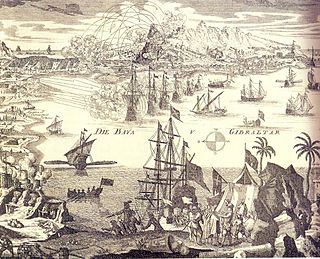
The siege of Gibraltar of 1727 saw Spanish forces besiege the British garrison of Gibraltar as part of the Anglo-Spanish War. Depending on the sources, Spanish troops numbered between 12,000 and 25,000. British defenders were 1,500 at the beginning of the siege, increasing up to about 5,000. After a five-month siege with several unsuccessful and costly assaults, Spanish troops gave up and withdrew. Following the failure the war drew to a close, opening the way for the 1728 Treaty of El Pardo and the Treaty of Seville signed in 1729.

The history of Gibraltar, a small peninsula on the southern Iberian coast near the entrance of the Mediterranean Sea, spans over 2,900 years. The peninsula has evolved from a place of reverence in ancient times into "one of the most densely fortified and fought-over places in Europe", as one historian has put it. Gibraltar's location has given it an outsized significance in the history of Europe and its fortified town, established in the Middle Ages, has hosted garrisons that sustained numerous sieges and battles over the centuries.

Lord Airey's Battery is an artillery battery in the British Overseas Territory of Gibraltar. It is located near the southern end of the Upper Rock Nature Reserve, just north of O'Hara's Battery. It was named after the Governor of Gibraltar, General Sir Richard Airey. Construction of the battery was completed in 1891. The first gun mounted on the battery was a 6-inch breech loading gun, which was replaced with a 9.2-inch Mark X BL gun by 1900. The gun at the battery was last fired in the 1970s. In 1997, it was discovered that Lord Airey's Shelter, adjacent to Lord Airey's Battery, was the site chosen for a covert World War II operation that entailed construction of a cave complex in the Rock of Gibraltar, to serve as an observation post. The battery is listed with the Gibraltar Heritage Trust.
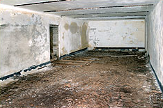
Operation Tracer was a secret Second World War Royal Navy military operation in Gibraltar, a British Overseas Territory and military base. The impetus for the stay-behind plan was the 1940 scheme by Germany to capture Gibraltar, code-named Operation Felix. Operation Tracer was the brainchild of Rear Admiral John Henry Godfrey, the Director of the Naval Intelligence Division of the Admiralty.
The Gibraltar Caving Group is an organisation based in the British Overseas Territory of Gibraltar. It forms the Caves and Cliffs Section of the Gibraltar Ornithological and Natural History Society. The group of skilled cavers and climbers has multiple roles, engaging in cave exploration and research, avian rescue, and rare plant discovery. It performs surveys and clears areas with limited access. However, it is perhaps most well known for the discovery that four of its members made in December 1996. While exploring tunnels in the southern portion of the Rock of Gibraltar, they found the entrance to Operation Tracer, also known colloquially as Stay Behind Cave. Rumours of a covert World War II observation post had circulated in Gibraltar for decades. The Gibraltar Caving Group continued its exploration and evaluation of the facility under the auspices of the Gibraltar Museum.

Martin's Cave is a cave in the British Overseas Territory of Gibraltar. It opens on the eastern cliffs of the Rock of Gibraltar, below its summit at O'Hara's Battery. It is an ancient sea cave, though it is now located over 700 feet (210 m) above the shore of the Mediterranean Sea. It is only accessible because Martin's Path was constructed.
Fig Tree Cave is a cave in the British Overseas Territory of Gibraltar. It is located on the eastern cliffs of the Rock of Gibraltar, not far from Martin's Cave within the Upper Rock Nature Reserve.

Monkey's Cave is a cave in the British Overseas Territory of Gibraltar. It has been used as part of the Fortifications of Gibraltar and in 1942 there was a convalescent hospital here. This building was later used as the HQ of the Royal Electrical & Mechanical Engineers.

Pete's Paradise Cave is a cave in the British Overseas Territory of Gibraltar. Explored in the 1960s and 1970s by a team led by George Palao, four skeletons have been unearthed in the cave, two of which were female skeletons with crushed skulls.

Buffadero Battery was an artillery battery in the British Overseas Territory of Gibraltar. It is located on Windmill Hill.

The Neanderthals in Gibraltar were among the first to be discovered by modern scientists and have been among the most well studied of their species according to a number of extinction studies which emphasize regional differences, usually claiming the Iberian Peninsula partially acted as a “refuge” for the shrinking Neanderthal populations and the Gibraltar population of Neanderthals as having been one of many dwindling populations of archaic human populations, existing just until around 42,000 years ago. Many other Neanderthal populations went extinct around the same time.
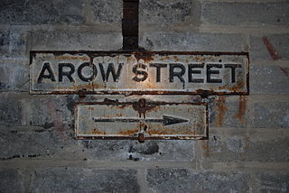
AROW Street is a tunnel in Gibraltar that was excavated in 1942. The tunnel, like Gibraltar's Great North Road, was large enough to take Army ammunition trucks.

The Great North Road is a large road tunnel in the British Overseas Territory of Gibraltar. It was constructed by the British military during World War II inside the Rock of Gibraltar and remains property of the Ministry of Defence to this day. The road allowed lorries to travel from the north to the south of Gibraltar entirely within the Rock. The tunnel still contains the remains of World War II buildings such as Nissen huts, kitchens, offices as well as a generating station and period anti-submarine nets.

Water supply and sanitation in Gibraltar have been major concerns for its inhabitants throughout its history, from medieval times to the present day. The climate of Gibraltar is a mild Mediterranean one with warm dry summers and cool wet winters. Since daily records of rainfall began in 1790, annual rainfall has averaged a mean of 838 millimetres (33.0 in) with the highest volumes in December and the lowest in July. However, most of Gibraltar's small land area is occupied by the Rock of Gibraltar, a limestone outcrop that is riddled with caves and crevices. There are no rivers, streams, or large bodies of water on the peninsula, which is connected to Spain via a narrow sandy isthmus.
Windmill Hill or Windmill Hill Flats is one of a pair of plateaux, known collectively as the Southern Plateaux, at the southern end of the British Overseas Territory of Gibraltar. It is located just to the south of the Rock of Gibraltar, which descends steeply to the plateau. Windmill Hill slopes down gently to the south with a height varying from 120 metres (390 ft) at the north end to 90 metres (300 ft) at the south end. It covers an area of about 19 hectares, though about 6 hectares at the north end is built over. The plateau is ringed to the south and east with a line of cliffs which descend to the second of the Southern Plateaux, Europa Flats, which is itself ringed by sea cliffs. Both plateaux are the product of marine erosion during the Quaternary period and subsequent tectonic uplift. Windmill Hill was originally on the shoreline and its cliffs were cut by the action of waves, before the ground was uplifted and the shoreline moved further out to the edge of what is now Europa Flats.

